- 1 Introduction
- 2 The Black Country 2039: Spatial Vision, Strategic Objectives and Strategic Priorities
- 3 Spatial Strategy
- 4 Infrastructure & Delivery
- 5 Health and Wellbeing
- 6 Housing
- 7 The Black Country Economy
- 8 The Black Country Centres
- 9 Transport
- 10 Environmental Transformation and Climate Change
- 11 Waste
- 12 Minerals
- 1 Sub-Areas and Site Allocations
- 2 Delivery, Monitoring, and Implementation
- 3 Appendix – changes to Local Plans
- 4 Appendix – Centres
- 5 Appendix – Black Country Plan Housing Trajectory
- 6 Appendix – Nature Recovery Network
- 7 Appendix – Glossary (to follow)

Draft Black Country Plan
(51) 1 Sub-Areas and Site Allocations
(748) A. Dudley
(2) Introduction
A1 Dudley has a rich cultural and industrial heritage and is often referred to as the historic capital of the Black Country, a name derived from its industrial past of coal mines and blast furnaces used for iron and steelmaking.
A2 Whilst once a key industrial town, a range of high quality and varied attractions now contribute to its historic landscape and heritage value, including: Dudley Castle, which dates back to the 11th Century; the internationally renowned Zoological Gardens; the open-air Black Country Living Museum; and Dudley Canal Trust, which has a sixteen-mile canal network. The tourism sector in Dudley makes a significant economic impact to the borough and the wider sub-region, supporting 10,575 jobs and generating some £405 million in the local economy[1].
A3 The borough is predominantly urban in character, but also contains extensive green space, natural assets and nature reserves. The southern and western fringes of the borough form part of the West Midlands Green Belt, which also extends into the urban area as a series of green 'corridors'. Some 18% of the land in the borough is designated as green belt; with a further 14% being public green space. The borough is home to one Special Area of Conservation (SAC), ten Sites of Special Scientific Interest (SSSIs), two National Nature Reserves and seven Local Nature Reserves. Dudley, along with the other districts of the Black Country, achieved UNESCO Global Geopark status in July 2020.
A4 Dudley has a growing and diverse population of over 320,000 residents, the second largest population across the BCA, of which 19.4% are young people; 60.2% are working age and 20.4% are aged 65 and above. There is an equal mix of male and females and in 2016 it was estimated that 12.6% of residents were from Black and Minority Ethnic groups[2]. At 72%, the borough's employment rate is higher than the average of 68.3% across the Black Country.
A5 Dudley was once a key industrial town generating wealth from coal and limestone mining, glass, iron and steel production. Despite a decline in activity since the 1970s, the area has retained manufacturing as a core industry, and today the sector employs 18,000 people in Dudley and contributes 15% of the local economy's GVA. The service sector in Dudley accounts for almost 80% of total employment with Public Administration, Education and the Health sector accounting for the highest proportion of employment.
A6 The Covid-19 pandemic had an immediate and significant impact on the UK economy in 2020, with a particular effect on the retail, tourism and hospitality sectors, as well as the manufacturing and construction sectors. Given the predominance of these sectors in Dudley, the pandemic has had a disproportionate adverse impact on the borough. Dudley Council has pro-actively responded to the challenges presented by Covid-19 and is shaping interventions across the borough to address the impact of the pandemic.
(14) The Strategy
A7 Notwithstanding the key issues outlined above, Dudley Council is continuing to provide a framework which includes placemaking as a tool in order to support, promote and delivereconomic and social regeneration, with significant public and private sector investment planned across the borough. In addition to recent investment, the area has the following key strengths to build on:
- People and communities – diverse, healthy and safe communities; thriving community and voluntary sector; and strong civic pride and community resilience;
- Place – world renowned cultural and heritage assets; strategic transport investments; a growing learning quarter; excellent digital connectivity and commitment to a sustainable environment;
- Business – sectoral strengths (health, retail, manufacturing, education); Dudley Enterprise Zone; Dudley Business First.
(10) Dudley Borough's Vision
A8 'Forging a future for all' is a shared vision for Dudley borough, developed in 2018, following extensive consultation with key partners and stakeholders. It is built around seven aspirations and goals to be reached by 2030:
- Towns – Dudley will have thriving, regenerated town centres where people are proud, work, shop and spend leisure time;
- Education – outstanding local schools, colleges and universities which secure excellent results for their learners;
- Business – a portfolio of quality industrial, retail and commercial premises;
- Tourism – an attractive tourism offer with a rich industrial, historical and geological focus
- Transport- improved public transport system linking Dudley borough to other Black Country strategic centres, the wider region and the national rail network;
- Environment – Dudley will be an affordable and attractive place to live, with a green network of high-quality parks, waterways and nature reserves that are valued by local people and visitors. There will be a strong affinity to local centres, supporting health, wellbeing and prosperity; and
- Community – Dudley will be a place with healthy, resilient, safe communities with high aspirations and the ability to shape their own future. Dudley will have improved health outcomes and higher wellbeing.
A9 The BCP forms an essential part of this strategy, supporting the recovery and growth of the economy, and providing for a continuous supply of new homes to meet the needs of local communities. The BCP will ensure that the borough's network of open spaces will be protected and enhanced to support its natural assets and can continue to provide opportunities to improve health and well-being whilst ensuring that development is located where it can provide convenient access for all sections of the community to work, shopping, health, education, leisure, green space and other facilities.
A10 The BCP supports the delivery of 13,235 new homes and 22ha employment land to 2039, supporting the growth of the borough's population to around 350,000 people by 2040. To plan for this growth, Dudley is prioritising locations that are both sustainable and deliverable in line with the Spatial Strategy set out in Policy CSP1. This growth will be supported by transport investment, focused on the rapid transit network and key road corridors as well as investment in walking and cycling.
Figure 15 - Dudley Spatial Plan
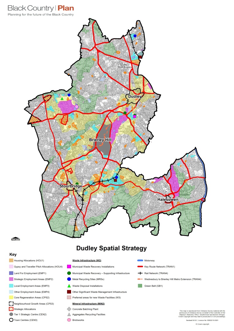
A11 Development and investment will be focussed on Brierley Hill Strategic Centre and three Core Regeneration Areas as summarised in Table 13 below.
(456) Table 13 - Dudley Growth Targets (2020 - 2039)
| Location | Housing (dwellings) | Employment land hectares (ha) |
| Strategic Centre | ||
| Brierley Hill (Strategic Centre) | 3,154 (inc 350 uplift) | 0 |
| Core Regeneration Areas | ||
| Central Core Regeneration Area | 1,712 | 7.51 |
| North West Core Regeneration Area | 1,145 | 1.4 |
| Jewellery Line Core Regeneration Area | 886 | 0 |
| Total Growth Network | 6,897 | 8.91 |
| Towns and Neighbourhoods Area | ||
| Dudley Towns and Neighbourhood Areas | 2,662 | 13.09 |
| Kingswinford Neighbourhood Growth Area | 860 | 0 |
| Total Towns and Neighbourhoods Area | 3,522 | 13.09 |
| Allowance for windfall housing sites (outside of the strategic centre) | 2,816 | 0 |
| Total | 13,235 | 22 |
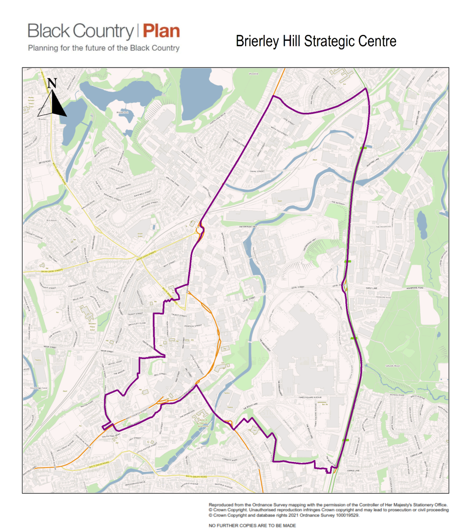
(43) Brierley Hill Strategic Centre
A12 Brierley Hill Strategic Centre, as designated on the Policies Map and shown in Figure 16, incorporates both the traditional High Street and the Merry Hill Centre. The traditional Brierley Hill High Street is a separate entity (i.e. excluding Merry Hill) and represents a retail area that serves its immediate hinterland and local community. The Merry Hill Centre is a key element of the Brierley Hill economic and physical landscape. It represents the single largest quantity of managed floorspace within the Black Country Local Authorities' (BCLA) area and is a regional centre of significance and ranks within the top 100 retail centres nationally (Experian). It has a wide catchment area that encompasses the Black Country and beyond.
A13 The BCP supports the diversification, repurposing and rejuvenation of the Strategic Centre. Changing shopping patterns and challenges to the high street will be addressed through increased flexibility and facilitating the consolidation of the shopping core (particularly to reduce vacancy rates), complemented by office and leisure-led mixed uses, and supported by maximising residential provision in all locations (including the use of upper floors). The future of the centre, as with most strategic centres across the Black Country, is dependent on ensuring less reliance on retail to generate footfall and to support alternative uses (potentially including mixed uses) that function both during the day and into the evening.
A14 The Brierley Hill Town Centre Investment Programme, supported by £10 million funding from the Government's Future High Street Fund, will deliver environmental improvements and improved pedestrian access to the High Street/Metro and Merry Hill. There is significant potential to redevelop vacant properties for office and new residential uses, alongside estate renewal opportunities. In addition, Dudley Council secured a further £1.8m of funding for the Brierley Hill High Street Heritage Action Zone (HAZ). It is a Government funded and run by Historic England with the aim of making the high street a more attractive, engaging and vibrant place for people to live, work and spend time. Brierley Hill High Street was one of 68 High Street across England selected to receive a share of the fund. The character and quality of both the cultural and civic function of the strategic centre and the built and natural environment will be improved, helping to make it a sustainable, healthy and attractive place to shop, live, work and visit. This will be achieved through BCP Policies (particularly CSP2, CEN2 and Environmental Transformation Policies).
Figure 16 - Brierley Hill Strategic Centre
A15 The Black Country Centres Study advises that the future prosperity of the Brierley Hill Strategic Centre is predicated on the need to reduce its reliance on the retail sector and instead seek alternative mixed uses that generate a daytime and evening economy.
A16 The key opportunities for Brierley Hill Strategic Centre are:
a) The diversification of uses within the centre, including the potential for a growth in leisure, restaurants and pubs, education and community facilities provision.
b) The identification of sites for a significant increase in new housing.
c) The programmed Midland Metro route, which runs through the centre with several stops proposed, including a potential interchange at Canal Street, including integrating stations within a network of pathways and cycleways.
d) The challenge of climate change and adapting to a low carbon future, including the further greening of the centre and the provision of renewable energy initiatives, including the provision of EV charging points.
e) Raising the profile of the High Street and capitalising on the successful Future High Streets (FHS) and Heritage Action Zone (HAZ) funding bids.
f) The Enterprise Zone (DY5 EZ), including the new university music faculty at The Waterfront.
g) The retention of The Waterfront primarily as an office centre.
h) The creation of high-quality public realm and more communal spaces and community focal points.
i) Improving the linkages between the Merry Hill Centre and Brierley Hill High Street, and the centre and the adjoining nature reserves.
j) Comprehensive 5G broadband coverage.
A17 Policy CSP2 sets the critical role of the four strategic centres as the key drivers to deliver the overall growth strategy. This is supplemented by Policy CEN2, which defines this role in more detail, providing specific guidance on the range of activities and scale of development that will be appropriate.
A18 The strategic centre benefits from an existing Area Action Plan (AAP) which was adopted in 2011. The AAP is currently the subject of a review and will be referred to as the Brierley Hill Plan (BHP). It is proposed that the BHP Issues and Options Report, which is due to be consulted upon after the consultation on the draft BCP, will present different options on the extent of the plan area and strategic centre boundaries. These will include an option that this boundary remains the same as those within the AAP. However, this may also mean that, subject to consultation on the BHP, the responses received and further assessment, the boundary of Brierley Hill Strategic Centre will change from that shown in Figure 16, and therefore be revised within later stages of the BCP.
A19 As stated above the AAP is currently subject to a review, with the review document (BHP) programmed for adoption shortly after the approval of the BCP. At this stage, the existing Brierley Hill AAP will be superseded (in total) by the new BHP, including the existing AAP land use allocations and policies.
A20 Therefore, for the purposes of applying Policies CEN1-6, within Brierley Hill Strategic Centre the following AAP policies are relevant in defining in-centre boundaries, but will be superseded post-BCP adoption within the BHP:
- Retail – Primary Shopping Area (AAP Policies 45 and 46)
- Office – AAP boundary (and AAP Policies 46 and 48)
- Leisure - AAP boundary (and AAP Policy 46)
A21 The housing capacity for the strategic centre outlined in Table 13 is based on the existing AAP allocations and recent evidence including the Black Country Centre's study and the DY5 Enterprise Zone Review by Cushman Wakefield. It includes an estimated uplift as detailed in the Black Country Urban Capacity Review 2021. This capacity will be further tested through the AAP review but provides a sound basis to understand the housing capacity for the Strategic Centre for the purposes of this Plan.
A22 The Brierley Hill AAP also has the following targets for other land uses, carried through from the Black Country Core Strategy: -
- Offices – an additional 220,000 sq. m (gross) of floorspace
- Comparison Retail – an additional 95,000 sq. m (gross) of floorspace
A23 However, current evidence highlights future uncertainty and little capacity to support additional floorspace for these land uses. Subject to further assessment, monitoring and review, this evidence will inform the scope for future land use allocations within the BHP.
(1) Central Core Regeneration Area
A24 The Central Core Regeneration Areais focussedon A461 Birmingham Road / Stourbridge Road and the Midland Metro Wednesbury to Brierley Hill extension. It is centred on the Wednesbury to Brierley Hill Growth Corridor, recognised as a priority for investment in the WMCA SIDP and the West Midlands Housing Deal.
A25 The areacontains the town centres of Dudley (which has a tourism focus of regional and national significance) and Stourbridge and runs adjacent to the Brierley Hill Strategic Centre.
A26 The area has major regeneration and renewal opportunities (inc. Netherton) for new employment and residential development, which will be well-connected by public transport via the new Dudley Interchange and the metro extension, to retail, office and leisure opportunities at Brierley Hill Strategic Centre and DY5 Enterprise Zone.
A27 The area is well connected to important road, canal and tram infrastructure, that link Dudley with the Black Country, the national rail network and the wider hinterland. Utilising the opportunities presented by the extended Metro line serving Wednesbury to Brierley Hill, proposals are being put forward to enhance rapid public transport connectivity along the Brierley Hill to Stourbridge corridor.
A28 In and around Dudley town centre a series of public sector-led interventions have been implemented since 2012 and as of 2021, a programme of further investment is on site or planned that will deliver the comprehensive regeneration of the area. This includes the Metro Extension; Dudley Transport Interchange; construction of the Very Light Rail National Innovation Centre (VLRNIC), the Black Country and Marches Institute of Technology and the extension of the Black Country Living Museum. There are further aspirations to deliver a new higher education facility, creating a University Centre and Learning Quarter at Castle Hill, that will stimulate the transformational change of the town centre.
A29 The Plan supports the role of the Central Core Regeneration Area as a major Growth Corridor and offers the opportunity to enhance the town centres of Dudley and Stourbridge and the corridor between them. The extension of the Metro through Dudley and Brierley Hill and the proposed further extension of a rapid transit system from Brierley Hill to Stourbridge, provide a game changing opportunity for the economic, social and environmental regeneration of the Borough. The location of housing and employment land opportunities along the route of the metro has the potential to facilitate significant housing and employment growth within the catchment of new stations.
A30 New development will respect and enhance the historic character and local distinctiveness of the area, with investment in environmental infrastructure including the canals, open spaces and wildlife habitats.
(3) Jewellery Line Core Regeneration Area
A31 The Jewellery Line Core Regeneration Area is focused on Lye whichhas been identified as a key housing-led regeneration area within the Dudley Borough Development Strategy[3]. In the region of 880 homes have been identified for development primarily on obsolete employment sites adjacent to the district centre, Lye Station and along the river Stour corridor.
A32 Opportunities exist to consolidate the area as a location for housing growth through the development of outdated or obsolete areas of industrial land and the exploitation of the excellent main-line rail links. Lye is well-connected to key road and rail networks. Lye Station lies on the Birmingham-Worcester railway line (Jewellery Line), with central Birmingham and future links to HS2 just 25 minutes away. The Wednesbury to Brierley Hill Metro extension, to be completed in 2022, will improve connectivity between Lye and employment opportunities at Brierley Hill, Dudley and the wider sub-region.
A33 Lye has been promoted as one of the Black Country Garden City locations[4] by the Black Country LEP. The original Garden City movement focused on improving quality of life and society living and functioning within the natural environment.
A34 The Plan will support the comprehensive development of Lye and its surrounding area as an Urban Garden City, creating an enhanced sense of place by seeking to improve its housing offer, realise the economic potential of the area, enhance the District Centre and local community facilities, whilst at the same time enhancing the Stour Valley and protecting the area's environment and nature conservation value.
North West Core Regeneration Area
A35 The North West Core Regeneration Area is focussed on the area of Pensnett. The area is served by Pensnett Trading Estate, one of the largest secure business estates in Europe, and home to 160 businesses, as well as adjacent industrial areas, providing a major employment location for the borough.
The Plan identifies opportunities for new residential communities, including the former Ketley Quarry site (strategic allocation DSA3), providing additional high-quality housing. New housing development will provide additional catchment for Kingswinford District Centre and for Pensnett and Wall Health local centres, helping to sustain their resilience and vitality as local centres. The BCP promotes enhanced connectivity to local facilities via more sustainable transport links (public transport, walking and cycling) and enhanced environmental improvements. Development will protect and enhance the area's wildlife corridor, which runs between the green belt from South Staffordshire into the urban areas of Brierley Hill, Pensnett and Dudley. There are also important ecological links to Fens Pools Local Nature Reserve and its Special Area of Conservation. Opportunities to contribute to the Wildlife Corridor between Fens Pools SAC and Baggeridge Country Park should be explored as part of future developments in the area.
(14) Dudley Towns and Neighbourhoods Area
A36 The Plan includes existing Towns and Neighbourhood Areas such as Halesowen, Sedgley, Coseley and Stourbridge. These areas are established residential and employment areas served by a network of district and local centres as defined in Policy CEN1 and CEN5, as well as providing local employment opportunities and community facilities to serve communities outside the strategic centre and Core Regeneration Areas. The BCP seeks to sustain and enhance these areas by ensuring a mix of good quality residential areas through a constant supply of small-scale development opportunities and potential renewal.
A37 The Towns and Neighbourhoods Area also includes a new Neighbourhood Growth Area in Kingswinford where two sites, Land south of Holbeache Lane / Wolverhampton Road in Kingswinford and Land at Swindon Road in Wall Heath, will be released from the green belt. This will be covered by a Strategic Allocation and will be the focus of new residential growth. There will be a requirement for development proposed on allocated sites to be of the highest quality and accommodate the correct infrastructure provision in the right places. Housing growth in this part of the borough will be supported by a strengthened local infrastructure, including local highway improvements, and creation of new green spaces of value for residents and wildlife. New housing development will provide additional catchment for Kingswinford District Centre and Wall Health local centres, helping to sustain their resilience and vitality as local centres. These requirements will be addressed through the production of master plans for the sites in accordance with Policy CPS3 and policies DSA1 and DSA2 below.
(20) Green Belt Areas
A38 The green belt areas of Dudley form a series of wedges and urban fringe areas and perform many different functions. The green belt areas do contain some rural landscapes, including agricultural land such as around Halesowen and Stourbridge. However, much of the green belt is captured within the urban area and provides a network of natural and formal open spaces, historic parks, such as Leasowes, education buildings, recreational facilities (such as Stourbridge and Halesowen golf courses), and other infrastructure (such as sewage works, sub-stations and cemeteries). Fens Pools SAC forms an important wedge of the green belt in the heart of borough's urban area. Opportunities to contribute to the wildlife corridor between Fens Pools SAC and Baggeridge Country Park is a priority for improvement and extension.
A39 This strategy will be delivered by:
a) A review of the adopted Brierley Hill Area Action Plan (AAP), to be known as the Brierley Hill Plan to refresh detailed site allocations within the strategic centre boundary in a comprehensive manner, in accordance with the Vision and strategic priorities set out in Policy CSP2.
b) The allocation of sites and implementation of policies in this Plan across the administrative area to accommodate housing and employment development.
c) The saving of policies contained in the Dudley Borough Development Strategy and the Dudley, Halesowen and Stourbridge Area Action Plans (AAP) unless specifically replaced by Policies in the Black Country Plan as listed in Appendix A1.
A40 A number of the Development Allocations replace existing allocations made in adopted Local Plan documents, which formed part of the Dudley Policies Map. Where this is the case, the previous allocation reference and the Local Plan document concerned are listed in Appendix A1. Appendix A2 provides details of all other Local Plan designations in Dudley that have also been replaced or amended through this Plan. Such changes have only been made where this is necessary to deliver development allocations.
A41 Where town centre policies contain a housing element which have counted towards Dudley's housing provision, but do not form part of the Black Country Plan allocations, these have been listed in Appendix A3.
A42 Detailed site and designation boundaries can be viewed on the online Policies Map for Dudley.
(3217) Development Allocations
A43 Outside the strategic centre, Table 14 provides details of all development allocations made through this Plan within Dudley. A number of these allocations are of strategic significance to the delivery of the Plan because of their size, either individually or in combination with adjoining allocations. Each strategic allocation has a separate policy, providing details of the specific constraints and requirements affecting development, which should be read alongside the information for the allocation provided in Table 14.
|
Table 14 - Dudley Housing Allocations in the Black Country Plan (BCP Policy HOU1) |
|||||||||
|
BCP Site Ref |
Previous local plan allocation (replaced unless stated) |
Site name and address |
Appropriate uses |
Indicative development capacity (net new homes) |
Gross Site Area (ha) |
Site area (ha) net |
Brownfield/ greenfield |
Anticipated delivery timescale |
Further information |
|
DUH208 |
Not previously allocated |
Land south of Holbeache Lane / Wolverhampton Road, Kingswinford |
housing |
330 (40 DPH) |
14.8 |
8.24 |
greenfield |
2030 - 2035 155 homes 2035 – 2039 175 homes |
Site removed from green belt. See Strategic Allocation Policy DSA1 for further details |
|
DUH211 |
Not previously allocated |
Land at Swindon Road, Wall Heath, Kingswinford (The Triangle Site) |
housing |
533 (40 DPH) |
26 |
13.30 |
greenfield |
2030 - 2035 280 homes 2035 - 2039 253 homes |
Site removed from green belt. See Strategic Allocation Policy DSA2 for further details. |
|
DUH218 |
Not previously allocated |
Lower Guys Lane, Lower Gornal |
housing |
25 (35 DPH) |
1.0 |
0.75 |
greenfield |
2030 - 2035 25 homes |
Site removed from green belt. See Policy CSP3 for further details. |
|
DUH203 |
Not previously allocated |
Ketley Quarry / Ketley Farm, Dudley Road, Kingswinford |
housing |
612 (40/45dph) |
20.81 |
13.52 |
brownfield |
2024 – 2029 50 homes 2030 - 2035 250 homes 2035- 2039 312 homes |
See Strategic Allocation Policy DSA3 |
|
DUH206 |
Not previously allocated |
Worcester Lane North, Stourbridge |
housing |
10 (35 DPH) |
0.61 |
0.61 |
greenfield |
2024 - 2029 10 homes |
Site removed from green belt. See Policy CSP3 for further details. SLINC mitigation required. Hedgerow to be protected. Railway to be considered. |
|
DUH207 |
Not previously allocated |
Worcester Lane Central, Stourbridge |
housing |
45 (35 DPH) |
2.29 |
1.37 |
greenfield |
2024 - 2029 45 homes |
Site removed from green belt. See Policy CSP3 for further details. SLINC mitigation required. Hedgerow to be protected. Railway to be considered. |
|
DUH209 |
Not previously allocated |
Worcester Lane South, Stourbridge |
housing |
60 (35 DPH) |
3.30 |
3.00 |
greenfield |
2030-35 60 homes |
Site removed from green belt. See Policy CSP3 for further details. SLINC mitigation required. |
|
DUH217 |
Not previously allocated |
Grazing Land Wollaston Farm, Wollaston, Stourbridge |
housing |
90 (35 DPH) |
3.77 |
2.56 |
greenfield |
2024-2029 20 homes 2030-35 70 homes |
Site removed from green belt. See Policy CSP3 for further details. Access constraints to be considered. |
|
DUH210 |
Not previously allocated |
Viewfield Crescent, Dudley |
housing |
24 (30DPH) |
1.56 |
0.83 |
greenfield |
2024-2029 24 homes |
Site removed from green belt. See Policy CSP3 for further details. Rights of Way-Along southern Boundary SLINC mitigation required. Steep incline on site. |
|
DUH222 |
Not previously allocated |
Corbyns Hall Open Space, Severn Drive, Pensnett |
Housing |
15 (15DPH) |
1.01 |
1.01 |
Greenfield |
2030-2035 15 homes |
Access constraints on site |
|
DUH223 |
DBDS E11B.6 |
Brockmoor Foundry North, Leys Road, Brockmoor, Brierley Hill |
housing |
60 (40DPH) |
1.9 |
1.7 |
brownfield |
2035-2039 60 homes |
Noise constraints from adjacent industrial works. |
|
DUH220 |
Not previously allocated |
VB Old Wharf, Old Wharf Road, Stourbridge |
Housing |
36 (35DPH) |
1.40 |
1.05 |
Brownfield |
2035-2039 36 homes |
Industrial area |
|
DUH001 |
DBDS H11B.1 |
Cookley Works, Leys Road, Brockmoor, Brierley Hill |
housing |
70 (45DPH) |
2.16 |
1.62 |
brownfield |
2030 – 2035 70 homes |
Access constraints on site. |
|
DUH002 |
DBDS H11B.16 |
Land at Old Wharf Road, Stourbridge |
housing |
230 (55 DPH) |
7.02 |
4.20 |
brownfield |
2024-2029 80 homes 2030 – 2035 100 homes 2035-2039 50 homes |
Majority of the site is cleared with main businesses relocated. Net area to allow for supporting infrastructure and open space requirements. |
|
DUH219 |
DBDS NETH.E1 |
Marriott Road, Netherton |
housing |
105 (40 DPH) |
3.50 |
2.6 |
brownfield |
2030-35 88 homes 2035-2039 17 homes |
SLINC mitigation required. Area of high historic townscape value and archaeological priority area. |
|
DUH003 |
DBDS H13.26 |
West of Engine Lane, north of the railway, Lye |
housing |
168 (40 DPH) |
6.00 |
4.25 |
brownfield |
2030- 2035 90 homes 2035-2039 78 homes |
Sustainable location close to Lye train station – likely to come forward as part of the Lye regeneration project. Net area allows for open space. |
|
DUH004 |
DBDS H13.29 |
Long Lane / Malt Mill Lane, Shell Corner |
housing |
13 (35 DPH) |
0.36 |
0.36 |
brownfield |
2024 – 2029 13 homes |
Site adjoins an existing housing commitment. |
|
DUH005 |
DBDS H13.4 |
Belmont Road, Lye |
housing |
12 (35 DPH) |
0.33 |
0.33 |
brownfield |
2024- 2029 12 homes |
Back – land site to the rear of properties |
|
DUH006 |
DBDS H13.5 |
Caledonia Sewage Works, Lye |
housing |
158 dwellings (35 DPH) |
6.24 |
3.97 |
brownfield |
2024- 2029 100 homes 2030-2035 58 homes |
Net area reduced to allow for flood risk areas and SLINC mitigation required. |
|
DUH007 |
DBDS H13.28 |
Clinic Drive, Lye |
mixed use |
10 (15 DPH) |
0.91 |
0.68 |
brownfield |
2024-2029 10 homes |
Mixed use site for community uses or supermarket provision with peripheral housing. |
|
DUH008 |
DBDS H13.10 |
116-120 Colley Gate, Cradley |
housing |
14 (60 DPH) |
0.25 |
0.25 |
brownfield |
2024 – 2029 14 homes |
Within Cradley / Windmill Hill Local Centre |
|
DUH009 |
DBDS H11B.7 |
Land off Delph Lane, Brierley Hill |
housing |
45 (35 DPH) |
1.28 |
1.28 |
brownfield |
2030 - 2035 45 homes |
Vacant site in a residential area |
|
DUH010 |
DBDS HO.10 |
Land off Ruiton Street / Colwall Road, Lower Gornal |
housing |
19 (40 DPH) |
0.46 |
0.46 |
brownfield |
2024-2029 19 homes |
Vacant land allocated in a residential area |
|
DUH058 |
DBDS NETH.H8 |
St Peter's Road, Netherton |
housing |
55 (50 DPH) |
1.2 |
0.89 |
brownfield |
2024-2029 55 homes |
Industrial area adjacent to the canal. |
|
DUH012 |
DBDS HO.12 |
Summit Place, Gornal Wood |
housing |
15 (35 DPH) |
0.43 |
0.43 |
greenfield |
2024-2029 15 homes |
Land adjacent to PH in a residential area |
|
DUH013 |
DBDS H16.11 |
Land adj. to 49 Highfields Road, Coseley |
housing |
13 (35 DPH) |
0.40 |
0.40 |
brownfield |
2024-2029 13 homes |
Vacant land adjacent to residential premises. |
|
DUH014 |
DBDS H13.21 |
Springfield Works, Pearson Street, Lye |
housing |
10 (40 DPH) |
0.35 |
0.25 |
brownfield |
2024-2029 10 homes |
Locally listed building means conversion is preferable. Indicative yield provided - based on 40 DPH (edge of centre). |
|
DUH015 |
DBDS H11B.24 |
Land at Plant Street, Mill Street and Bridge Street, Wordsley |
housing |
43 (45 DPH) |
1.29 |
0.97 |
brownfield |
2024-2029 43 homes |
Industrial area with fragmented ownership. Site area and capacity has been reduced in line with owners' intentions. The site adjoins the canal conservation area and has historic buildings. |
|
DUH016 |
DBDS H11B.18 |
Leys Road / Moor Street, Brierley Hill |
housing |
78 (40 DPH) |
2.77 |
1.95 |
brownfield |
2035 – 2039 78 homes |
Industrial premises including a former garage site. |
|
DUH017 |
DBDS H11B.22 |
Quantum Works, Enville Street, Stourbridge |
housing |
14 (40 DPH) |
0.36 |
0.36 |
brownfield |
2024-2029 14 homes |
Narrow and restrictive site resulting in access constraints. |
|
DUH018 |
DBDS H13.14 |
East of Balds Lane, Lye |
housing |
68 (35 DPH) |
2.6 |
1.95 |
brownfield |
2030 – 2035 68 homes |
Underused industrial site. Current planning application on the site shows a willing landowner for redevelopment. |
|
DUH019 |
DBDS H13.23 |
Rufford Road, Stourbridge |
housing |
16 (40 DPH) |
0.41 |
0.41 |
brownfield |
2024-2029 16 homes |
Capacity and site area reduced in line with owner's intentions. |
|
DUH020 |
DBDS H13.12 |
Lyde Green / Cradley Road, Cradley |
housing |
27 (40 DPH) |
0.69 |
0.69 |
brownfield |
2024-2029 27 homes |
Capacity and site area reduced in line with owners' intentions and to allow for a buffer adjacent to the canal, in line with planning policy. |
|
DUH021 |
DBDS NETH.H13 |
Land at corner of Saltwells Road and Halesowen Road, Netherton |
housing |
49 (35 DPH) |
1.40 |
1.40 |
brownfield |
2024-2029 49 homes |
Industrial area adjacent to the canal. Land levels likely to reduce capacity. |
|
DUH022 |
DBDS H13.17 |
Land off Thorns Road, Lye (North) |
housing |
105 (40 DPH) |
3.42 |
2.61 |
brownfield |
2024-2029 60 homes 2030-35 45 homes |
Site area and capacity reduced in line with landowner consultation exercise. |
|
DUH023 |
DBDS H13.16 |
Land off Engine Lane, (south of railway), Lye |
housing |
68 (40 DPH) |
1.70 |
1.70 |
brownfield |
2035 – 2039 68 homes |
Sustainable location close to Lye Station. Other uses may be considered acceptable if there is a proven need for flexibility, subject to the proposed use being appropriate and non-conflicting with residential uses. |
|
DUH024 |
DBDS H13.27 |
East of Engine Lane (south of the railway), Lye |
housing |
35 (35 DPH) |
1.25 |
0.93 |
brownfield |
2030 – 2035 35 homes |
Sustainable location close to Lye Station. Other uses may be considered acceptable if there is a proven need for flexibility, subject to the proposed use being appropriate and non-conflicting with residential uses. |
|
DUH025 |
DBDS H13.15 |
Bott Lane / Dudley Road, Lye |
housing |
43 (35 DPH) |
1.25 |
1.25 |
brownfield |
2035- 2039 43 homes |
Sustainable location close to Lye Station. Other uses may be considered acceptable if there is a proven need for flexibility, subject to the proposed use being appropriate and non-conflicting with residential uses. |
|
DUH027 |
DBDS H11A.21 |
280 Stourbridge Road (former Henry Boot training centre), Holly Hall, Dudley |
housing |
22 (80 DPH) |
0.28 |
0.28 |
brownfield |
2024 – 2029 22 homes |
Adjacent site has outline planning permission for residential development. |
|
DUH028 |
DBDS H11B.27 |
Land opposite Spicer Lodge, Enville Street, Stourbridge |
housing |
10 (40 DPH) |
0.25 |
0.25 |
brownfield |
2024 – 2029 10 homes |
Yield based on an apartment scheme. |
|
DUH029 |
DBDS H13.31 |
St Marks House, Brook Street, Lye |
housing |
12 (40 DPH) |
0.29 |
0.29 |
brownfield |
2024 – 2029 12 homes |
Yield based on an apartment scheme. |
|
DUH030 |
DBDS H11A.23 |
Shaw Road / New Road, Dudley |
housing |
16 (55 DPH) |
0.39 |
0.29 |
brownfield |
2024 - 2029 16 homes |
Sustainable location. Original site boundary reduced following landowner engagement. Site is a difficult shape which will reduce capacity. |
|
DUH031 |
DBDS NETH.H15 |
The Straits, Lower Gornal |
housing |
23 (35 DPH) |
0.64 |
0.64 |
greenfield |
2030 - 2035 23 homes |
Green space on borough boundary. |
|
DUH032 |
DBDS H11A.22 |
The Woodlands, Dixons Green Road |
housing |
22 (55 DPH) |
0.40 |
0.40 |
brownfield |
2024-2029 22 homes |
Site of demolished care home. |
|
DUH034 |
DBDS NETH.E1 |
Industrial land at Marriott Road and Cradley Road |
housing |
88 (35 DPH) |
3.34 |
2.5 |
brownfield |
2030-2035 88 homes |
Industrial area within local employment area. |
|
DUH035 |
DBDS E13.6 |
Hays Lane, Stour Vale Road, Lye |
housing |
58 (50DPH) |
1.45 |
1.09 |
brownfield |
2035 – 2039 58 homes |
AHHTV area and heritage asset on site for conversion potential. Any proposed development will needs to meet requirement of Policies DEL2 / EMP4 and has potential contamination on site. |
|
DUH036 |
DBDS E13.2 |
Leona Industrial Estate, Nimmings Road, Blackheath |
housing |
21 (40 DPH) |
0.53 |
0.53 |
brownfield |
2030-2035 21 homes |
Subject to DEL 2 / EMP 4. |
|
DUH044 |
DBDS H13.12 |
Land adj. rear 84-86 Lyde Green, Halesowen |
housing |
17 (35 DPH) |
0.50 |
0.50 |
brownfield |
2030 – 2035 17 homes |
Mixed use scheme to allow for ground floor retail units. |
|
DUH045 |
DBDS H13.13 |
Former factory site, Park Lane, Cradley |
housing |
80 (40 DPH) |
3.6 |
2.00 |
brownfield |
2024 - 2029 80 homes |
Subject to a planning application currently being assessed – residential development. |
|
DUH046 |
DBDS H14.4 |
Former MEB Headquarters, Mucklow Hill Halesowen |
housing |
60 (40 DPH) |
1.50 |
1.50 |
brownfield |
2030-2035 60 homes |
Mixed use development opportunity. |
|
DUH049 |
DBDS H16.2 |
Former Mons Hill Campus (Dudley College), Wrens Hill Road, Dudley |
housing |
30 (50 DPH) |
0.81 |
0.60 |
brownfield |
2024-2029 30 homes |
Site is being progressed through pre-application discussions - adjacent residential development. |
|
DUH053 |
DBDS ES13.3 |
Timmis Road, Lye |
housing |
17 (40 DPH) |
0.6 |
0.45 |
brownfield |
2024-2029 17 homes |
Planning application on site. |
|
DUH051 |
DBDS E11B.5 |
Northmoor Estate, Brierley Hill |
housing |
22 (50 DPH) |
0.53 |
0.4 |
brownfield |
2024-2029 22 homes |
|
|
DUH057 |
DBDS H16.9 |
Land adjacent to Pear Tree Lane, Coseley |
housing |
38 (50 DPH) |
0.99 |
0.74 |
greenfield |
2024-2029 38 homes |
|
|
DUH060 |
DBDS H13.22 |
Foredraft Street, Cradley (two sites, A and B) |
housing |
18 (35 DPH) |
0.53 |
0.53 |
brownfield |
2024-2029 18 homes |
Site is subject to a live planning application. |
|
DUH059 |
DBDS H14.3 |
Former New Hawne Colliery, Hayseech Road, Halesowen |
housing |
15 (30 DPH) |
0.63 |
0.63 |
brownfield |
2024-2029 15 homes |
Grade II and Grade II* listed buildings on site, therefore sympathetic conversion is required, and any proposals need to be sympathetic to the setting of the designated heritage assets and to the AHHLV and APA |
|
DUH033 |
DBDS H11B.26 |
Former Hospital Site, Ridge Hill, Brierley Hill Road, Wordsley |
housing |
103 |
3.5 |
3.5 |
brownfield |
2024-2029 103 homes |
Reserved matters approved for 103 units (P19/1777) |
|
DUH061 |
DBDS H10.4 |
Former Ibstock Works Brick Ltd. Stallings Lane, Kingswindford |
housing |
148 (40 DPH) |
7.58 |
4.5 |
brownfield |
2024-2029 148 homes |
Outline planning permission P16/1461 P20/0631 – reserved matters for 148 units, currently being assessed. |
|
DUH011 |
DBDS H0.17 |
Bourne Street, Coseley |
housing |
79 (30DPH) |
2.8 |
2.57 |
brownfield |
2024-2029 79 homes |
Former refuse tip. Will require remediation. Outline permission for up to 100 homes (P17/0184). Current application for 79 homes (P20/1306) |
|
DUH026 |
DBDS H11A.19 |
Land at Bull Street, Dudley |
housing |
80 (40DPH) |
2.06 |
2.06 |
brownfield |
2024-2029 80 homes |
Reserved matters for 80 units approved in October 2020 (P20/0647). |
|
DUH063 |
SAAP S9 |
Bradley Road West, Stourbridge |
housing |
80 (45 DPH) |
0.25 |
0.25 |
brownfield |
2024-2029 80 homes |
Housing site in the Stourbridge AAP |
|
DUH062 |
DBDS H16.1 |
Land at Birmingham New Road, Coseley |
housing |
472 |
13.4 |
brownfield |
2024-2029 472 homes |
Reserved matters for 472 units (P19/0611). Site area reduced from previous allocation. Part of the site re-allocated to employment use. |
|
|
DUH066 |
Not previously allocated |
Sandvik Ltd, Manor Way, Halesowen |
housing |
60 (40 DPH) |
1.5 |
1.5 |
brownfield |
2024-2029 60 homes |
Mixed use development opportunity. |
|
DUH205 |
Not previously allocated |
National Works, Hall Street, Dudley |
housing |
150 (55 DPH) |
5.0 |
2.9 |
brownfield |
2035-2039 150 homes |
The site occupies an elevated location with respect to surrounding land uses to the north, east and south. The layout / density design will need to prevent overlooking. Tree retention is a possibility in the south east section of the site adjacent to Bean Road. The whole site is within an Area of High Historic Townscape Value - Kates Hill and Dixons Green Road; mixed historic housing and industry |
|
DUH050 |
Not previously allocated |
Car park, Oak Court, Dudley |
housing |
24 |
0.37 |
0.37 |
brownfield |
2024-2029 24 homes |
|
|
DUH039 |
Not previously allocated |
Land rear of Salcombe Grove, Coseley |
housing |
44 |
1.1 |
0.80 |
greenfield |
2024-2029 44 homes |
|
|
DUH054 |
Not previously allocated |
Garage site adjacent Hinbrook Road, Dudley |
housing |
14 |
0.29 |
0.29 |
brownfield |
2024-2029 14 homes |
Garage site in centre of residential estate. |
|
DUH052 |
Not previously allocated |
Land rear of 294 - 364 Stourbridge Road, Halesowen |
housing |
39 (40 DPH) |
1.34 |
1.0 |
brownfield |
2024-2029 39 homes |
Narrow access and substantial tree coverage on site. |
|
DUH055 |
Not previously allocated |
Land at Anchor Hill, Delph Road, Brierley Hill |
housing |
28 (40 DPH) |
0.88 |
0.66 |
brownfield |
2024-2029 28 homes |
Site is being progressed through pre-application discussions. |
|
DUH056 |
Not previously allocated |
Land at Corporation Road and Cavell Road, Dudley |
housing |
20 (50 DPH) |
0.42 |
0.42 |
brownfield |
2024-2029 20 homes |
Site is being progressed through pre-application discussions. |
|
DUH038 |
Not previously allocated |
Land between Heath Road and Copse Road, Netherton |
housing |
27 (40 DPH) |
0.76 |
0.57 |
brownfield |
2024 – 2029 27 homes |
Open space |
|
DUH040 |
Not previously allocated |
High Street, Wollaston, Stourbridge |
housing |
14 (45 DPH) |
0.40 |
0.30 |
brownfield |
2024-2029 14 homes |
Non-conforming use adjacent to the river. |
|
DUH041 |
Not previously allocated |
Land rear of Two Gates Lane, Cradley |
housing |
24 (45 DPH) |
0.68 |
0.51 |
greenfield |
2024-2029 24 homes |
|
|
DUH042 |
Not previously allocated |
Woodman Inn, 31 Leys Road, Brockmoor |
housing |
12 (40 DPH) |
0.26 |
0.26 |
brownfield |
2024-2029 12 homes |
Former public house with residential to the south and Cookley Wharf industrial estate to the north. |
|
DUH047 |
Not previously allocated |
Land adjacent 32 Whitegates Road, Coseley |
housing |
10 (40 DPH) |
0.25 |
0.25 |
brownfield |
2024-2029 10 homes |
Site is being progressed through pre-application discussions. |
|
DUH037 |
Not previously allocated |
206 Thorns Road, Quarry Bank |
housing |
26 (50 DPH) |
0.55 |
0.47 |
brownfield |
2024 – 2029 26 homes |
Potential access constraints. |
|
DUH048 |
Not previously allocated |
Hampshire House, 434 High Street, Kingswinford |
housing |
30 (70 DPH) |
0.44 |
0.44 |
brownfield |
2024-2029 30 homes |
Office building and associated parking, close to Kingswinford local centre. |
|
DUH212 |
Not previously allocated |
Lewis Rd, Lye |
housing |
38 (45 DPH) |
4.14 |
1.4 |
greenfield |
2024-29 38 homes |
Tree mitigation works. Mitigation for loss of public open space. Land remediation works following landfill and mining works. |
|
DUH204 |
Not previously allocated |
Wellington Road and Dock Lane, Dudley |
housing |
88 (45 DPH) |
2.2 |
1.65 |
brownfield |
2030- 2035 88 homes 14 homes – density uplift |
Edge of centre location, net area reduced to allow for supporting infrastructure and open space requirements. |
|
DUH213 |
Not previously allocated |
Lapwood Avenue, Kingswinford |
housing |
45 (40 DPH) |
1.38 |
1.38 |
greenfield |
2030 - 2035 45 homes |
|
|
DUH214 |
Not previously allocated |
Seymour Road, Wollescote |
housing |
4 (40DPH) |
0.19 |
0.15 |
greenfield |
2024-2029 4 homes |
Site has steep topography. |
|
DUH215 |
Not previously allocated |
Bent Street, Brierley Hill |
housing |
7 (40 DPH) |
0.15 |
0.15 |
greenfield |
2024-2029 7 homes |
|
|
DUH216 |
Not previously allocated |
Bryce Road, Pensnett |
housing |
115 (40 DPH) |
4.0 |
3.0 |
greenfield |
2024- 2029 55 homes 2030 – 2035 60 homes |
Residential bounding all sides of the site. Former primary school now demolished to the north east. Allow for 25% open space and infrastructure. |
|
DUH221 |
Not previously allocated |
Standhills Road, Kingswinford South |
housing |
52 (35DPH) |
3.93 |
1.57 |
brownfield |
2035 – 2039 52 homes |
To be included in Masterplan of Ketley Quarry (inc site access). Protected trees and SLINC mitigation required. |
|
DUH042 |
Not previously allocated |
Land at Blowers Green Road, Dudley |
housing |
75 (45 DPH) |
1.88 |
1.41 |
brownfield |
2024 – 2029 75 homes 12 homes – density uplift |
Housing redevelopment would remove non-conforming use. |
|
DUH043 |
Not previously allocated |
Woodman Inn |
housing |
12 (46 DPH) |
0.26 |
0.26 |
brownfield |
||
|
DUH065 |
Church Road, Netherton |
housing |
29 |
0.88 |
0.66 |
brownfield |
2024 – 2029 29 homes |
Housing renewal site |
|
|
DUH064 |
Baptist Road, Netherton (Former Arley Court and Compton Court) |
housing |
49 |
1.45 |
1.09 |
brownfield |
2024 – 2029 49 homes |
Housing renewal site |
|
|
Table 15 - Dudley Gypsy and Traveller Pitch Carried Forward Allocations in Black Country Plan (BCP Policy HOU1 / HOU4) |
|||||||||
|
BCP Site Ref |
Previous local plan allocation (replaced unless stated) |
Site name and address |
Appropriate uses |
Indicative development capacity (net homes) |
Gross site area (ha) (brownfield /greenfield) |
Indicative net developable area (ha) |
Net density (dph) |
Anticipated delivery timescale |
Further information |
|
DUGT01 |
DBDS – L5 |
Delph Lane, Brierley Hill |
Gypsy and Traveller Pitches |
4 pitches |
0.12 |
0.12 |
N/A |
Existing allocation |
Established in 1965 and allocated in local plan in 2016. Potential further capacity for an additional two pitches |
|
DUGT02 |
DBDS – L5 |
Holbeache Lane, Wall Heath |
Gypsy and Traveller Pitches |
4 pitches |
0.24 |
0.24 |
N/A |
Existing allocation |
Established since 1960 without formal planning permission. Site allocated in Dudley Borough Development Strategy to regularise the site in planning policy. Potential further capacity for an additional 4 pitches |
|
DUGT03 |
DBDS – L5 |
Dudley Road, Lye |
Gypsy and Traveller Pitches |
6 pitches |
0.3 |
0.3 |
N/A |
Existing allocation |
Established in 1953 and allocated in local plan in 2016 |
|
DUGT04 |
DBDS – L5 |
Smithy Lane, Pensnett |
Gypsy and Traveller Pitches |
15 pitches |
0.45 |
0.45 |
N/A |
Existing allocation |
Established in 1984 allocated in local plan in 2016 |
|
DUGT05 |
DBDS – L5 |
Oak Lane, Pensnett |
Gypsy and Traveller Pitches |
22 pitches |
1.1 |
1.1 |
N/A |
Existing allocation |
Allocated in Local Plan since 1993. Site established in 1974 |
|
DUGT10 |
Not previously allocated |
Saltbrook Scrapyard, Salbrook Road, Halesowen |
Gypsy and Traveller Pitches |
2 pitches |
2.92 |
2.19 |
N/A |
Existing |
Site secured planning permission in 2019 and was implemented in 2020. Site allocated in BCP |
|
Table 16 - Dudley Employment Allocations in Black Country Plan (BCP Policy EMP1) |
|||||||
|
BCP Site Ref |
Previous local plan allocation (replaced unless stated) or other source |
Site name and address |
Appropriate uses |
Indicative development capacity (employment land floorspace sqm) |
Gross site area (ha) |
Anticipated delivery timescale |
Further information |
|
DUE323 |
DBDS E16.2 |
Fountain Lane / Budden Road, Coseley |
Mixed Employment Uses B2/B8/E(g) |
5,000 |
1.79 |
Post 2026 |
Land adjoining existing industrial unit within Local Employment Area. |
|
DUE326 |
DBDS E10.2 |
Gibbons Industrial Park / United Steels, Pensnett |
Mixed Employment Uses B2/B8/E(g) |
4,500 |
0.74 |
2021-26 |
Vacant land adjoining steelworks within Local Employment Area. |
|
DUE123 |
DBDS ES10.1 |
Dandy Bank Road Phases 2 and 3, Pensnett |
Mixed Employment Uses B2/B8/E(g) |
5,869 |
4.27 |
2021-26 |
Within DY5 EZ Extension to Pensnett Trading Estate Strategic Employment Area, granted planning permission for three industrial units in 2020 (P19/1532). |
|
DUE327 |
DBDS ES10.1/E10.1 |
Tansey Green Road, Pensnett |
Mixed Employment Uses B2/B8/E(g) |
7,000 |
2.33 |
2021-26 |
Within DY5 EZ Land around existing brickworks - possible former surface working of clay and marl and tipping of waste material. |
|
DUE320 |
DBDS E10.1 |
Dreadnought Road, Pensnett |
Mixed Employment Uses B2/B8/E(g) |
3,716 |
0.99 |
2021-26 |
Within DY5 EZ Part of area around existing brickworks Planning permission granted for industrial unit (mixed employment uses) in 2019 (P19/0942) |
|
DUE132 |
DBDS ES11A.3 |
Hulbert Drive, Blackbrook Valley |
Mixed Employment Uses B2/B8/E(g) |
8,440 |
2.04 |
2021-26 |
Within DY5 EZ Planning applications for industrial employment uses recently submitted (P20/1527 and P20/1565) |
|
DUE136 |
DBDS ES11A.4 |
Narrowboat Way, Blackbrook Valley |
Mixed Employment Uses B2/B8/E(g) |
5,000 |
1.48 |
Post 2026 |
Within DY5 EZ Adverse ground conditions are required to be remediated |
|
DUE137 |
DBDS ES11A.7 |
Brewins Way, Blackbrook Valley |
Mixed Employment Uses B2/B8/E(g) |
1,850 |
0.75 |
2021-26 |
Within DY5 EZ. Planning Permission granted for the erection of an industrial unit to house a metal recycling operation (P19/1426). |
|
DUE147 |
DBDS NETH.ES9 |
Cradley Road, Westminster Industrial Estate, Netherton |
Mixed Employment Uses B2/B8/E(g) |
1,600 |
0.48 |
2021-26 |
Existing industrial units on 2/3 sides. |
|
DUE149 |
DBDS ES11B.2 |
Moor Street, Brierley Hill |
Mixed Employment Uses B2/B8/E(g) |
9,000 |
2.17 |
Post 2026 |
Land alongside and including redundant freight line (former depot). |
|
DUE187 |
DBDS ES14.3 |
Steelpark Road, Halesowen |
Mixed Employment Uses B2/B8/E(g) |
2,700 |
0.40 |
2021-26 |
Existing industrial units on 4 sides. |
|
DUE198 |
DBDS ES13.1 |
Cakemore Road, Blackheath |
Mixed Employment Uses B2/B8/E(g) |
5,234 |
1.18 |
2021-26 |
Reserved Matters approved for mixed industrial use - P20/0348 |
|
DUE322 |
DBDS E11A.1 |
Grazebrook Park, Blackbrook Valley, |
Mixed Employment Uses B2/B8/E(g) |
1,704 |
0.47 |
2021-26 |
Within DY5 EZ Recent planning application for industrial employment uses submitted – P20/1528 |
|
DUE321 |
DBDS H16.1 |
Bean Road, Coseley |
Mixed Employment Uses B2/B8/E(g) |
4,000 |
2.16 |
Post 2026 |
Adverse ground conditions to be remediated. Whole site previously allocated for housing. Site area now amended to include employment land allocation on part of site. |
|
DUE135 |
DBDS ES11A.8 |
New Road, Netherton |
Mixed Employment Uses B2/B8/E(g) |
2,800 |
0.75 |
2021-26 |
Within DY5 EZ and adjacent to existing industrial units |
Waste Allocations
(1) Strategic Waste Management Sites
A44 The existing strategic sites identified on the Waste Key Diagram are the significant waste management facilities operating in the Black Country. They have been identified through a detailed analysis of all known licenced and exempt facilities in each authority area. Under Policy W2 (Waste Sites), the BCA will safeguard all existing strategic and other waste management facilities from inappropriate development, in order to maintain existing levels of waste management capacity and meet Strategic Priority 13, "To manage waste as a resource and minimise the amount produced and sent to landfill".
A45 The strategic waste management sites within Dudley Borough are listed in Table 17:
|
Table 17 - Strategic Waste Management Sites in Dudley (BCP Policy W2 |
|||
|
BCP Site Ref/location |
Previous Local Plan Ref (2011 Black Country Core Strategy, BCCS) |
Site Name and Address |
Operational capacity (tonnes per annum, tpa) |
|
Total Landfill Capacity (tonnes) (end of 2018) |
|||
|
Municipal Waste Recovery Installations |
|||
|
WS01 |
WSD6 |
Dudley Energy from Waste (EfW) facility, Lister Road Depot, Lister Road, Dudley |
95,000 |
|
Municipal Waste Recovery – supporting infrastructure |
|||
|
WS04 |
WSD11 (see DBDS page 20) |
Blowers Green Recycling Depot, Blowers Green Road, Dudley |
40,000 |
|
WS05 |
n/a |
Lister Road Transfer Station, Lister Road Depot, Lister Road, Dudley |
23,500 |
|
WS06 |
WSD10 |
Stourbridge Household Waste Recycling Centre (HWRC) off Birmingham Street (A458), Stourbridge |
20,000 |
|
Waste Disposal Installations |
|||
|
WS16 |
WSD5 |
Himley Quarry Landfill, Oak Lane, Kingswinford |
150,000 / 432,000 |
|
Significant Metal Recycling Sites (MRS) |
|||
|
WS21 |
WSD9 |
Shakespeare's MRS, Oak Lane, Kingswinford |
40,000 |
|
WS22 |
WSD1 |
Sims MRS Halesowen, James Scott Road, Cradley, Halesowen (formerly E Coley Steel) |
35,000 |
|
WS23 |
n/a |
Wades of Wednesbury, Webb Street, Coseley |
20,000 |
|
Other Significant Waste Management Infrastructure |
|||
|
WS34 |
n/a |
AB Waste Management and Skip Hire (formerly Bloomfield Recycling) |
45,000 |
|
WS35 |
n/a |
Green World Recycling, Hayes Trading Estate, Folkes Road, Lye |
50,000 |
Preferred Areas for New Waste Facilities
A46 A number of employment areas have been identified in the Black Country Waste Study (BCWS) as being most suited to the development of new waste recovery, waste treatment and waste transfer infrastructure.
A47 Under Policy W3 (Preferred Areas for New Waste Facilities), these areas are considered least likely to give rise to land use conflicts, and in several cases, there is already co-location of existing waste facilities to which new sites would contribute.
A48 There is only one such area in Dudley Borough, and this is identified on the Waste Key Diagram and listed in Table 18:
Table 18 - Preferred areas for new waste facilities in Dudley (BCP Policy W3)
|
Area Ref |
Previous Local Plan Ref (2017 Dudley Borough Development Strategy, DBDS) |
Address |
Area (hectares) |
|
WPD1 |
E16.2 (local employment area) |
Bloomfield Road / Budden Road, Coseley (note that parts of this area extend into Sandwell Borough) |
28.1 |
A49 The Black Country Minerals Study (BCMS, Tables 12.10 and 12.9) lists all known existing mineral sites and mineral infrastructure sites in the Black Country. Existing mineral sites within the Black Country include permitted mineral extraction sites, stockpiles, brick and tile works, and a pot clay factory. Existing Black Country mineral infrastructure sites include secondary / recycled aggregates production, rail-linked aggregates depots, coating plants, ready-mix (RMX) concrete batching plants, manufacture of concrete products, and dry silo mortar (DSM) plants.
A50 Under Policy MIN2 (Minerals Safeguarding Areas, MSAs), the BCA will safeguard all existing mineral sites and mineral infrastructure sites from inappropriate development – this being necessary in order to retain existing capacity, and thereby helping to make best use of and conserve the Black Country's finite mineral resources and meet Strategic Priority 14, to manage the Black Country's mineral resources (Objective - Meeting our resource and infrastructure needs).
A51 The locations of these Black Country mineral sites and mineral infrastructure sites are identified on the Minerals Key Diagram; those sites located within Dudley Borough are listed in the following tables:
Table 19 - Mineral Sites in Dudley
|
BCP Site Ref |
Previous Local Plan Ref |
Site Name |
Location |
Use |
|
MSD1 |
n/a |
Dreadnought Brickworks |
Dreadnought Road, Pensnett |
Operational brickworks |
Table 20 - Mineral infrastructure sites in Dudley (BCP Policy MIN2)
|
Site Ref |
Previous Local Plan Ref |
Site Name |
Location |
Type |
|
MID1 |
n/a |
Accumix Concrete |
Ham Lane, Kingswinford |
Concrete Batching Plant |
|
MID2 |
n/a |
Bell Recycling Centre |
Oak Lane, Kingswinford |
Aggregates Recycling |
|
MID3 |
n/a |
Breedon Dudley (Brierley Hill) Concrete Plant |
Off Delph Road, Brierley Hill |
Concrete Batching Plant |
|
MID4 |
n/a |
Dudleymix Concrete |
Peartree Lane, Netherton |
Concrete Batching Plant |
|
MID5 |
n/a |
Oak Lane Aggregates Recycling Site |
Oak Lane, Kingswinford |
Aggregates Recycling |
|
MID6 |
n/a |
SW Jackson Aggregates |
Off Oak Lane, Kingswinford |
Concrete Batching Plant |
|
MID7 |
n/a |
Regen R8 Limited |
Timmis Road, Lye |
Aggregates Recycling |
Policies for Strategic Allocations
(1295) Policy DSA1 Land South of Holbeach Lane /Wolverhampton Road, Kingswinford
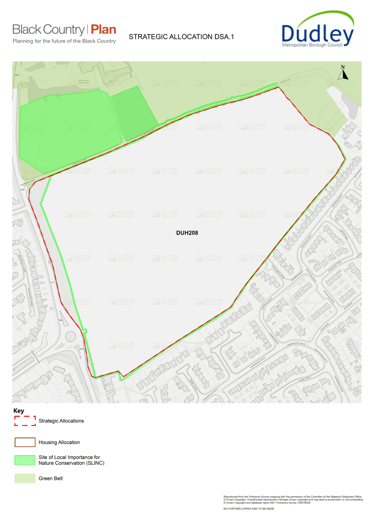
A52 The Land South of Holbeache Lane / Wolverhampton Road Strategic Allocation falls within the Kingswinford Neighbourhood Growth Area and covers BCP Allocation DUH208. It is proposed that the site be removed from the green belt and be allocated to deliver approximately 330 homes at an average net density of 40 dph.
A53 The estimated phasing of delivery is:
- 2030 - 2035 155 homes
- 2035 – 2039 175 homes
A54 There will be a requirement for the development of the site to deliver homes and infrastructure of the highest quality design and functionality, and to accommodate the required infrastructure provision to fully mitigate for the release of this site from the green belt and to deliver maximum benefits to the local environment and community. The key planning requirements for the Holbeache Lane / Wolverhampton Road Strategic Allocation are set out below. Other standard policy requirements, as set out in the BCP and Dudley Local Plan documents and SPDs, will also apply. A masterplan will be prepared to guide the development of the Strategic Allocation. This will provide further detail on the requirements set out in this policy and will provide a spatial framework for development.
A55 The site is in one ownership and is situated in close proximity to strategic sites and Policy DSA2: Land at Swindon Road, Wall Heath, Kingswinford Strategic Allocation and Policy DSA3: Ketley Quarry Strategic Allocation. The cumulative impact of the sites (and other housing / employment allocations) on local infrastructure provision will need to be considered, in terms of:
- school place impacts;
- highways impacts;
- delivery of green belt loss mitigation;
- delivery of biodiversity net gain;
- delivery of recreational open space improvement.
A56 Once the BCP has been adopted, allocations should be developed in accordance with the criteria identified in respect of each site and all general policy requirements, including any necessary developer contributions.
School Place Requirements
A57 It is currently anticipated that both primary and secondary school place requirements arising from housing developments in the north west of Dudley over the Plan period will be capable of being met through extensions to existing primary and secondary schools. Pedestrian and public transport improvements to increase accessibility to local primary and secondary schools may be required in accordance with Policy HOU2.
Highways Requirements
A58 It is essential that a cycling and walking network which includes active travel routes around key sites should form a key part of the site layout providing connections to all nearby local amenities, including local primary schools and local centres. These connections should include pedestrian crossing improvements at the A449 to enable safe crossing of the highway. Details will need to be set out in the master plan.
A59 It is considered that a vehicular access point could be gained from the existing roundabout (A449 / A491) to the west of the site, subject to junction capacity analysis and wider transport modelling. A potential second access to Oak Lane via an improved Ham Lane could be provided. Highway and junction improvements would be required to Wall Heath and Kingswinford centres, as well as Stalling Lane and A449/ Himley Road. Details will be set out in the masterplan.
Green Belt Loss Mitigation Requirements
A60 Measures to provide sufficient mitigation for the loss of green belt cannot be confirmed yet; rather this will be set out in the publication version of the BCP.
A61 There will be a requirement for all green belt loss mitigation works and any necessary transfer of land ownership to be completed before the substantial completion of development.
A62 The green belt boundary has been redrawn around the development site. In most cases there is an existing landscaped buffer or road that provides a defensible new green belt boundary. It is recommended that a buffer of landscaped open space is provided along the northern portion of the site, in order to ensure development is appropriately screened from the historically sensitive Holbeache Lane and Holbeache House. Developments should be designed to minimise potential harm to the integrity of remaining green belt areas and to landscape character, as identified in the Black Country Green Belt Study and Black Country Landscape Sensitivity Assessment.
Nature Conservation and Net Biodiversity Gain Requirements
A63 All existing SINCs, SLINCs, tree preservation orders, hedgerows, woodland and significant trees both within and adjoining the development sites should be retained, protected and incorporated sympathetically into the design of development. Sufficient buffer areas should be provided at the edge of these habitat areas, particularly mature trees and hedgerows, to allow them to thrive following development (see ENV4).
A64 It is anticipated that net biodiversity gain requirements for the developments will be met through delivery of the green belt loss mitigation requirements, subject to the minimum 10% requirement identified in the Environment Bill / Act and the requirements of Policy ENV3.
Historic Environment Requirements
A65 Located adjacent to this allocation, on its northern boundary, is the Grade II* listed Holbeache House and its curtilage (List Entry Number 1228293). The impact of any proposals on the setting and significance of this designated heritage asset will be a material planning consideration for development. Also, in close proximity to this allocation, on its northern and north-eastern boundary, is the Oak Farm Wedge Area of High Historic Landscape Value (AHHLV 38), a non-designated heritage asset.
A66 Applicants will therefore be required to support their proposals with a Statement of Heritage Significance (prepared in accordance with Historic England's latest guidance) illustrating that proposals have been formulated with a full appreciation of the requirements of Section 66(1) of the Planning (Listed Buildings and Conservation Areas) Act 1990 and with the policies relating to designated and non-designated heritage assets laid out in the NPPF and local plan.
A67 The design of the development should not impact on the existing character and appearance of Holbeache Lane, which provides a significant contribution to the setting and significance of Holbeache House and is also one of the positive features that contributes to the Oak Farm Wedge AHHLV.
Recreational Open Space Requirements
A68 The incorporation of high-quality landscaping across the development should be a significant forethought of the design process. A well landscaped green buffer is required to the north of the site, which should also provide a neighbourhood area for play. In effect this should separate development completely from the historically sensitive elements to the north.
A69 Further to this, there should be some offsetting of development to the south of the site where existing dwelling houses are located, and well-used informal pedestrian routes exist. It is understood that a high-pressure gas pipeline runs across the middle of the site, which may require some offsetting of development if it were to be retained.
Sustainable Drainage Requirements
A70 Naturalised sustainable drainage systems that are sufficient to retain greenfield runoff rates should be provided for the site, in accordance with Policy CC6. An allowance for the space necessary to accommodate these systems has been made when defining the indicative net developable area. This allowance may be adjusted when the master plan is prepared.
Local Wastewater Treatment Capacity
A71 This site is served by Roundhill WwTW and it is not anticipated that there are any issues with the site handling additional flow during the Plan period.
Design principles
A72 The development of the site will form a new community and neighbourhood on green belt land; all proposals must have distinguishable merit in their design and form. Only high-quality design that is bespoke, unique and specific to the site will be acceptable, in line with the requirements of Policies CSP4 and ENV9 among others. The incorporation of high-quality landscaping across the development should be a significant part of the initial design process. A well-landscaped green buffer is required to the north of the site, which should also provide a neighbourhood area for play. It should also be a continuous green thread, which links in with other treed areas and hedgerows in and around the site to provide a meaningful wildlife corridor. All mature trees and hedgerows should be maintained as this will be vital to mitigate some of the visual impact of developing this green belt site.
A73 Development should sit behind the existing tree-lined boundary along the A449 and should be outward looking making use of continuous perimeter roads to aid connectivity and permeability. The site as a whole should be highly permeable, avoiding the use of private drives and cul-de-sacs that limit on-foot and cycle connectivity. The layout of development should consider as a priority the amenity of existing residents to the south of the site, specifically those with dwellings that back onto it. Where possible the site layout should also seek to maintain and maximise key views across the development (predominantly south-east to north-west). Although there are no key commutable desire lines across the site, at current it is well-used for leisure by residents. This reinforces the need for a well-connected and permeable site layout as well as for an enhanced element of open space to make up for the loss of the site as whole.
A74 Due to the sensitive historic location of the site and existing green belt setting, it is considered that apartments would not be acceptable here.
Nature Conservation and Net Biodiversity Gain Requirements
A75 The site is currently a large arable field surrounded by species-rich hedgerows – designated as SLINC, with rich ground flora. The site is adjacent to a woodland SLINC and has connectivity to the wider open countryside to the north of the site via arable fields and hedgerows. Mature hedgerows form the boundary of the arable area and the grassland areas of the site. These will need to be retained as part of the development as they support a wide variety of flora, support breeding birds and create a nesting and foraging habitat for many species. They include large stretches of intact, stock-proof hedge, and stretches of defunct, non-stock proof, hedge with gaps. The hedgerow adjacent to the Wolverhampton Road (A491) has several large, mature trees within it, including Norway maple and aspen. These will need to be retained as part of the development.
(1335) Policy DSA2– Land at Swindon Road, Wall Heath, Kingswinford (The Triangle site) Strategic Allocation
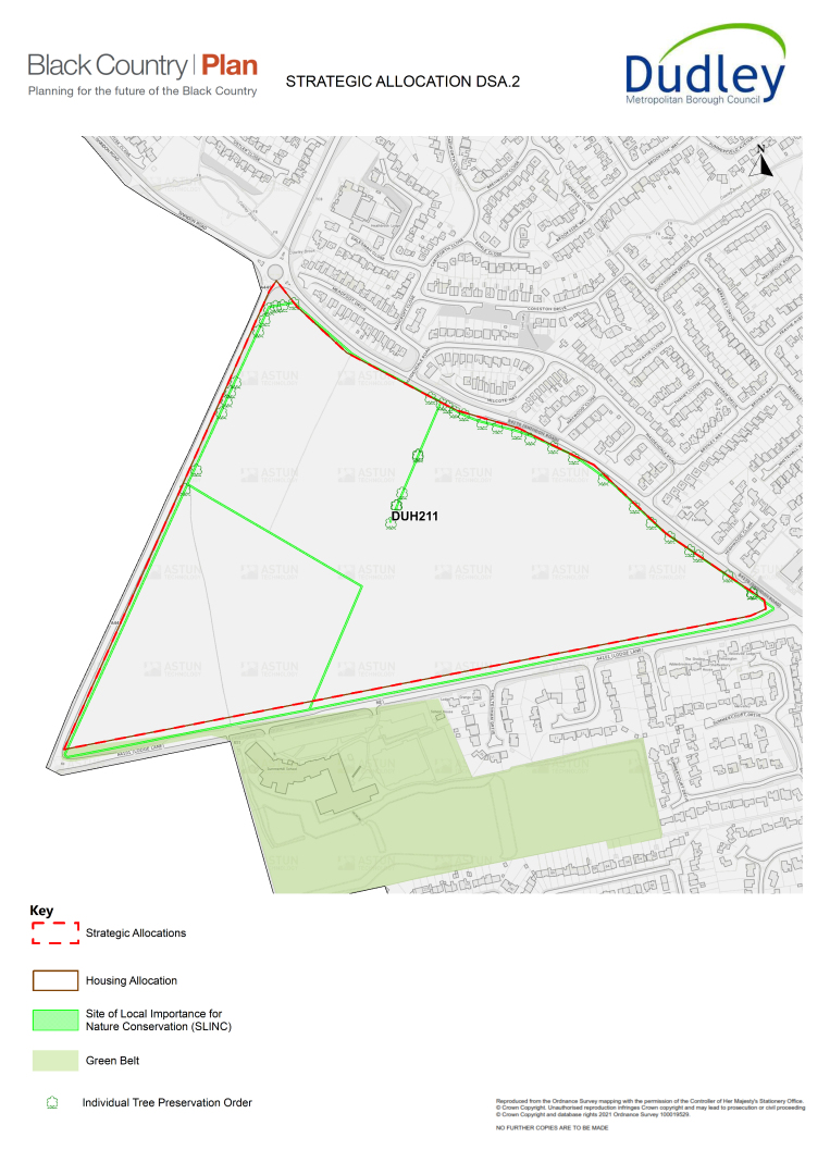
A76 Land at Swindon Road, Wall Heath, Kingswinford will be allocated for new residential growth and will form part of the Kingswinford Neighbourhood Growth Area; it includes BCP Allocation DUH211. It is proposed that the site be removed from the green belt and be allocated to deliver approximately 533 homes at an average net density of 40 dph.
A77 The estimated phasing of delivery is:
- 2030 - 2035 280 homes
- 2035- 2039 253 homes
A78 There will be a requirement for the development of the site to deliver homes and infrastructure of the highest quality design and functionality, and to accommodate the required infrastructure provision to fully mitigate for the release of this site from the green belt and to deliver maximum benefits to the local environment and community. There will be a requirement for the development of the site to be of the highest quality and accommodate the correct infrastructure provision in the right places. The key planning requirements for the Swindon Road, Wall Heath Strategic Allocation are set out below. Other standard policy requirements, as set out in the BCP and Dudley Local Plan documents and SPDs, will also apply. A master plan will be prepared to guide the development of the strategic allocation. This will provide further detail on the requirements set out in this Policy and will provide a spatial framework for development.
A79 The site is in one ownership and is situated near strategic sites: Policy DSA1: South of Holbeache Lane / Wolverhampton Road Strategic Allocation and Policy DSA3: Ketley Quarry Strategic Allocation. The cumulative impact of these sites (and other housing / employment allocations) on local infrastructure provision will need to be considered, in terms of:
- school place impacts;
- highways impacts;
- delivery of green belt loss mitigation;
- delivery of biodiversity net gain;
- delivery of recreational open space improvement.
A80 Once the BCP has been adopted, allocations should be developed in accordance with the criteria identified in respect of each site and all general policy requirements, including any necessary developer contributions.
School Place Requirements
A81 It is currently anticipated that both primary and secondary school place requirements arising from housing developments in the north west of Dudley over the Plan period will be capable of being met through extensions to existing primary and secondary schools. Pedestrian and public transport improvements to increase accessibility to local primary and secondary schools may be required in accordance with Policy HOU2.
A82 Should it be determined that some form of primary school provision is required as the BCP progresses towards adoption, this may need to be accommodated on the site and land will need to be allocated to accommodate a two-form entry primary school (approximately 2.4ha).
Highways Requirements
A83 Highway infrastructure is necessary in order for any development to function effectively and to minimise impacts on surrounding road junctions. It is considered that there should be three points of vehicular access, including from Swindon Road to the north and Lodge Lane to the south. The number of access points required, and their precise location should be subject to further detailed transport assessment. Connections should be made through the site, so that pedestrians and vehicles can travel from Swindon Road, through to the A449 or Lodge Lane as they choose. A cycling and walking network which includes active travel routes around key sites should form a key part of the site layout providing connections to all nearby local amenities, including local primary schools and local centres. Details will need to be set out in the master plan.
Green Belt Loss Mitigation Requirements
A84 Measures to provide sufficient mitigation for the loss of green belt cannot be confirmed yet; rather this will be set out in the publication version of the BCP.
A85 There will be a requirement for all green belt loss mitigation works and any necessary transfer of land ownership to be completed before substantial completion of development. Being a green belt site, the retention and provision of high-quality landscaping should be a significant first stage in the design process. Aside from the aforementioned considerations regarding open space, mature trees along the periphery and within the site should be retained, as well as hedgerows within the site where possible.
A86 The green belt boundary has been redrawn around the development site. In most cases there is an existing landscaped buffer or road that provides a defensible new green belt boundary. A significant level of well-landscaped open space should be retained, providing a landscaped open space buffer along the western side of the site where the impact on views is highest and there are clear constraints to development (notably the north-westernmost and south-westernmost fields, due to their topography and the potential impact of development on visual amenity in this location). Development will be concentrated in the easternmost portion of the site, where impacts on views and the surrounding area would be lowest. It is likely that higher densities could be accommodated here than in locations to the west. Developments should be designed to minimise potential harm to the integrity of remaining green belt areas and landscape character, as identified in the Black Country Green Belt Study and Black Country Landscape Sensitivity Assessment.
Nature Conservation and Net Biodiversity Gain Requirements
A87 The site sits on the fringe of the urban area, with links to wider greenspace and open countryside. The site is surrounded by hedgerows that are of high ecological value due to the species that they support. Both the internal and boundary hedgerows contain mature trees, which should be retained as part of the site's features. These current hedgerow lines are growing along pre-existing / old boundaries. The site as a whole assists in the movement and migration of species as well as providing important feeding areas for local and migratory wildlife populations. There is potential for bat roosting sites in the mature hedgerow trees. Bat and bird boxes could be installed on some of the mature trees to provide nesting and roosting opportunities. A mixed semi-natural woodland occurs in the form of a small wooded copse, situated in the west of the site. Opportunities for enhancement and planting around this part of the site should be explored in line with Policy ENV4 - Trees, Woodland and Hedgerows. A management plan for the long-term maintenance of the woodland would also be required.
A88 It is anticipated that net biodiversity gain requirements for the developments will be met through delivery of the green belt loss mitigation requirements set out above.
A89 Policy ENV3 - will apply to this site.
Historic Environment Requirements
A90 Located adjacent to this strategic allocation, on its south-eastern edge is the Grade II listed Summerhill Hotel (List Entry Number 1228678). The impact of any development proposals on the setting and significance of this designated heritage asset will be a material planning consideration. Applicants will therefore be required to support their proposals with a Statement of Heritage Significance (prepared in accordance with Historic England's latest guidance) illustrating that proposals have been formulated with a full appreciation of the requirements of Section 66(1) of the Planning (Listed Buildings and Conservation Areas) Act 1990 and with the policies relating to designated heritage assets laid out in the NPPF and local plan.
A91 Within this allocation there is one site recorded on the Council's Historic Environment Record (HER), HER record 12113, which relates to a medieval book fitting. In view of this and in view of the fact that the allocation still retains the majority of its original field boundaries (as marked on the first edition OS) applicants will be required to support their proposals with a historic environment desk-based assessment, undertaken in accordance with guidance provided by the Chartered Institute for Archaeologist (CIfA).
Recreational Open Space Requirements
A92 Subject to satisfactory delivery of mitigation for the loss of green belt, it is considered that the local area will have good access to existing recreational open space, allotment, play and sports facilities that have the capacity to meet the varied needs of new residents, in line with adopted open space standards. Therefore, no new on-site open space will be required, beyond that necessary to protect existing nature conservation value and provide sufficient natural, sustainable drainage systems. However, it will be necessary to provide quality walking and cycle routes within the developments that provide easy, quick and safe access to nearby open spaces and the countryside.
Sustainable Drainage Requirements
A93 Naturalised sustainable drainage systems that are sufficient to retain greenfield runoff rates should be provided for the site, in accordance with Policy CC6. An allowance for the space necessary to accommodate these systems has been made when defining the indicative net developable area. This allowance may be adjusted when the master plan is prepared.
Local Wastewater Treatment Capacity
A94 This site is served by Roundhill WwTW and it is not anticipated that there are any issues with the site handling additional flow during the Plan period.
Design principles
A95 Due to the tree-lined periphery of the site and its topography, it is considered that development would be best located at the edge of the site, fronting directly onto Swindon Road and Lodge Lane. The chosen layout must be highly permeable and well connected, prioritising pedestrian and cycle users, maximising the feeling of enclosure and responding to human scales. Proposals should avoid the use of private drives and cul-de-sacs, as these hinder good on-foot / cycle connectivity. As such it is likely that proposals brought forward will differ to much of the existing morphology (cul-de-sac) in the surrounding area. As the site will create a new community / neighbourhood on green belt land, proposals must have distinguishable merit in their design and form. Only high-quality design that is bespoke, unique and specific to the site will be acceptable.
A96 Existing desire lines are well-used by local residents for leisure and walking to / from Summerhill School in the south. These should be retained and routes for school commuters diverted as little as possible.
(108)
Policy DSA3 - Land at Ketley Quarry, Kingswinford
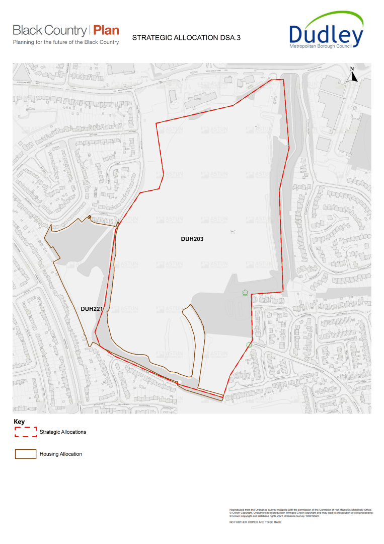
A97 Land at Ketley Quarry, Kingswinford will be allocated for new residential growth and will form part of the North West Regeneration Core Area covering BCP Allocations DUH203 and DUH221. The site's gross area is 20.81ha of which 13.52 ha of the site is developable for 612 dwellings based on 40 - 45dph.
A98 The estimated phasing of delivery is:
- 2024 – 2029 50 homes
- 2030 - 2035 250 homes
- 2035 - 2039 312 homes
A99 There will be a requirement for the development of the site to deliver homes and infrastructure be of the highest quality design and functionality, and to accommodate the required infrastructure provision in appropriate locations. The key planning requirements for the Ketley Quarry Strategic Allocation are set out below. Other standard policy requirements, as set out in the BCP and Dudley Local Plan documents and SPDs, will also apply. A master plan will be prepared to guide the development of the strategic allocation. This will provide further detail on the requirements set out in this Policy and will provide a spatial framework for development.
A100 The Quarry and adjacent sites are in separate ownership and are situated in close proximity to strategic sites identified in Policy DSA1: South of Holbeache Lane / Wolverhampton Road and Policy DSA2: land at Swindon Road, Wall Heath. The cumulative impact of these sites (and other housing / employment allocations) on local infrastructure provision will need to be considered, in terms of:
- school place impacts;
- highways impacts;
- delivery of biodiversity net gain;
- delivery of recreational open space improvements
A101 Once the BCP has been adopted, allocations should be developed in accordance with the criteria identified in respect of each site and all other relevant general policy requirements, including any necessary developer contributions.
School Place Requirements
A102 It is currently anticipated that both primary and secondary school place requirements arising from housing developments in the north west of Dudley over the Plan period will be capable of being met through extensions to existing primary and secondary schools. Pedestrian and public transport improvements to increase accessibility to local primary and secondary schools may be required in accordance with Policy HOU2.
A103 Should it be determined that some form of primary school provision is required as the BCP progresses towards adoption, this may need to be accommodated on the site and land will need to be allocated to accommodate a two-form entry primary school (approximately 2.4ha).
Highways Requirements
A104 Highway infrastructure is necessary in order for any development to function effectively and to minimise impacts on surrounding road junctions. It is considered that there should be vehicular access, of Dudley Road with a possible secondary access of Ketley Road, by Ketley Farm. The number of access points required, and their precise location should be subject to further detailed transport assessment. A cycling and walking network which includes active travel routes around key sites should form a key part of the site layout providing connections to all nearby local amenities, including local primary schools and local centres. Details will need to be set out in the master plan.
Nature Conservation and Net Biodiversity Gain Requirements
A105 There is a statutory designation for features of geological significance (SSSI) at the north of the site and two non-statutory geological designations (SINC) within the site. The SSSI designation is a geological outcrop of the Etruria Formation, created during the Carboniferous Period (359 - 299 million years ago). The wider site is designated as a SLINC. The vast majority of the site is a disused quarry and is made up of bare ground and large mounds of quarry spoil. Parts of the quarry have become vegetated with early successional species and tall ruderal vegetation. The disused Tansy Green branch railway line runs to the east of the site, providing a further link to Fens Pools Nature Reserve to the south. Dawley Brook to the east of the site is designated as a SINC. The site also contains three distinct areas of woodland, with the belt to the east and southwest of the site acting as a boundary feature.
A106 Bat and bird surveys, including for barn owls, will need to be carried out in the abandoned farmhouse and surrounding buildings. Other surveys such as reptile and badger surveys may also be required.
A107 Policy ENV3 - Biodiversity Net Gain will apply to this site.
Historic Environment Requirements
A108 This allocation is the site of the former Ketley Colliery (HER 7963) recorded as being mostly abandoned by the production of the first edition OS in 1884. It also contains the site of Ketley Quarry (also recorded on the first edition OS), which is one of the 'Geo-sites' located within the Black Country Geopark, (see Policy ENV6)[5].
A109 Located in the north-west corner of this allocation, adjacent to the road, is the site of a weighbridge and its associated Weights and Measures building (HER15424). The buildings first appeared on the Fourth Edition OS (1937-1948). Any proposed development should seek to incorporate these heritage assets into any future proposals for this part of the site along with suitable interpretation information.
A110 Located in the southern part of the allocation is the site of Stourbridge Extension Canal (HER 7385), built during the 1830s and opened in 1840. Proposals for the site should seek to include within it sympathetic ways of revealing the significance of this heritage asset.
Recreational Open Space Requirements
A111 It will be necessary to provide good-quality walking and cycle routes within the developments, which can provide easy, quick and safe access to nearby open spaces and the countryside.
Sustainable Drainage Requirements
A112 Naturalised sustainable drainage systems that are sufficient to retain greenfield runoff rates should be provided for the site, in accordance with Policy CC6. An allowance for the space necessary to accommodate these systems has been made when defining the indicative net developable area. This allowance may be adjusted when the master plan is prepared.
Local Wastewater Treatment Capacity
A113 This site is served by Roundhill WwTW and it is not anticipated that there are any issues with the site handling additional flow during the Plan period.
Design principles
A114 New development will have a density of no more than 40 - 45dph and will also retain a network of public open space across the site. Any proposed development should create a permeable layout by connecting the surrounding vehicle roads and pedestrian routes with a network of public open space and tree-lined streets. Layouts should incorporate 'back to back garden' housing and avoid the rear or sides of gardens facing the streets and public realm. Existing trees and on-site biodiversity value (according to the outcome of robust surveys) must be safeguarded and incorporated into the proposed layouts. These assets should form part of the publicly accessible open space and should not be located within any private plots, except in exceptional circumstance. Corner plots should be designed to address both aspects e.g. consider and propose a dual building frontage to minimise blank / dead frontages. All public open space should be overlooked by housing.
Local Green Space Designations
A115 Local Green Space designation is a way to provide special protection for green areas of particular importance to local communities. The Council has designated an area of green space for special protection, as outlined in the policy table below. The Local Green Space has been put forward by the local community, with a strong evidence base, due to its local importance. The area has been identified on the Dudley Proposals Map.
(107) Policy DSA4 Corbett Meadow Local Green Space
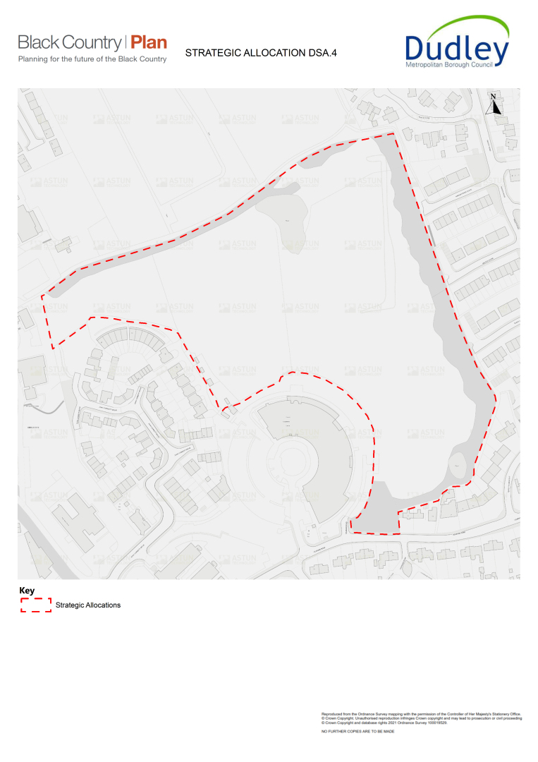
A116 The area shown on the Proposals Map is allocated as Corbett Meadow Local Green Space. In line with national policy the site will be protected from inappropriate development, unless there are very special circumstances that outweigh the harm to the site.
A117 The views of the local community will also need to be taken into account when considering any development proposals on the site.
A118 Designation of land as Local Green Space is set out in the NPPF, allowing communities to identify and protect green areas of particular importance to them. It has been demonstrated that Corbett Meadow meets the criteria set out in Paragraph 100 of the NPPF (2019). The site of the meadow was purchased by local philanthropist John Corbett in 1892 to provide a hospital and the gardens and public grounds were to be used for the purposes of a public park. The site supports a variety of wildlife and is made up of flower-rich lowland meadow pasture, many wooded areas of veteran age and natural ponds.
Nature Conservation Alterations and Designations
A119 Dudley Council will safeguard and enhance designated nature conservation sites, habitats and features through the development process and in accordance with the Black Country Plan, in particular Policy ENV1 and the Dudley Borough Development Strategy Policy S21.
A120 A number of designations or amendments have been made to Nature Conservation sites which have been adopted by the Council. Details of the sites are shown in Appendix A4. In addition, site and designation boundaries can be viewed on the online Policies Map for Dudley.
(39) B. Sandwell
Introduction
B.1 Sandwell is a metropolitan borough in the Black Country, made up of six towns: Oldbury, Rowley Regis, Smethwick, Tipton, Wednesbury and West Bromwich. With 327,378 residents, Sandwell has the third largest population in the West Midlands Combined Authority area and is the 34th largest local authority in Great Britain. The borough's population is predicted to grow faster than both that of the West Midlands and the national average.
B.2 Sandwell has many growing and productive businesses and a higher than average proportion of its businesses are small, but residents are not always able to take up opportunities related to those employment and economic activities. Local businesses will often need a highly skilled workforce to be able to grow to meet modern demands; that workforce needs training and support to help deliver and accelerate innovation. Sandwell also has a limited amount of the type of high quality land needed to enable businesses to expand and grow in the borough's industrial core.
B.3 Creating a clean, attractive and safe living environment in Sandwell is a key priority, as is developing a robust response to climate change in an area with a complex industrial heritage and its associated legacy of land, water and air pollution
B.4 Although Sandwell has many challenges, it also has a significant number of opportunities. The BCP and Sandwell's own Inclusive Economy Deal will be focusing on the challenges for people, place and business and the opportunities that are available to make a difference.
B.5 The aim is to deliver a healthier, more successful future for the people of Sandwell – working closely together with residents, businesses and other stakeholders.
(3) The Strategy
B.6 The 2030 Vision for Sandwell is:
'It's where we call home and where we're proud to belong - where we choose to bring up our families, where we feel safe and cared for, enjoying good health, rewarding work, feeling connected and valued in our neighbourhoods and communities, confident in the future, and benefiting fully from a revitalised West Midlands'.
B.7 The BCP forms an essential part of this strategy, supporting the re-energising, diversification and re-purposing of the borough, supporting the recovery and growth of our economy, and providing for a continuous supply of new homes to meet the needs of our communities.
B.8 The BCP will ensure that the borough's network of open spaces will be protected and enhanced to support its natural assets, and continue to provide opportunities to improve health and well-being whilst ensuring at the same time, that development is located where it can provide convenient access for all sections of the community to work, shopping, health, education, leisure, green space and other facilities.
B.9 This Plan supports the delivery of 9,158 new homes and 126,000 jobs to 2039, supporting the growth of the borough's population and a workforce of 108,000. To plan for this growth, the Council is prioritising locations that are both sustainable and deliverable in line with the Spatial Strategy set out in Policy CSP1.
Figure 17 - Sandwell Spatial Plan
(10) Table 21 - Sandwell Growth targets (net) 2020 - 2039
|
Location |
Housing |
Employment Land allocations (ha) |
|
|
The Growth Network |
|||
|
Strategic Centre |
201 200 (Uplift to be tested) = 401 |
0 |
|
|
Sandwell Central Core Regeneration Area |
2,032 |
28 |
|
|
Towns and Neighbourhood Areas |
|||
|
Neighbourhood Growth Areas |
N/A |
N/A |
|
|
Other Sites in Towns and Neighbourhood Areas |
4,997 |
0 |
|
|
Small Windfall Housing Sites |
1,728 |
N/A |
|
|
Total |
9,158 |
28 |
|
West Bromwich Strategic Centre
B.10 West Bromwich Strategic Centre, as designated on the Policies Map and shown on Figure 17 is the third largest centre in the Black Country and It is the focus for a wide range of civic, retail, cultural and leisure functions. The centre is organised around a strong linear high street form. The High Street runs north-west to south-east with a focus on high street retail activity along the pedestrianised Princess Parade / Duchess Parade section, which is enclosed by the West Bromwich Ringway. It is a highly accessible location by a range of public transport options including rail, metro and bus services.
B.11 This Plan supports the diversification, repurposing and rejuvenation of the Strategic Centre, being a focus for a well-balanced mix of commercial, business and service uses. Changing shopping patterns and challenges to the high street will be addressed through increased flexibility and facilitating the consolidation of the shopping core (particularly to reduce vacancy rates), complemented by surrounding office and leisure-led mixed uses, and supported by maximising residential provision in all locations (including the use of upper floors).
B.12 The future of the centre, as with most Strategic Centres across the Black Country, is dependent on ensuring less reliance on retail to generate footfall and to generate alternative uses (potentially mixed uses) that function both during the day and into the evening.
Figure 18 - West Bromwich Strategic Centre
B.13 The Strategic Centre benefits from an existing Area Action Plan (AAP) which was adopted in 2011. The AAP will be reviewed following the adoption of the BCP. Until the AAP review is completed, all AAP policies remain relevant for proposals within the BCP boundary of West Bromwich Strategic Centre.
B.14 Therefore, for the purposes of applying Policies CEN1- CEN6, within West Bromwich Strategic Centre the following AAP policies are relevant in defining in-centre boundaries:
- Retail – Primary Shopping Area (AAP Policies)
- Conservation Area - AAP boundary (and AAP Policy) WBP8
- The housing capacity for West Bromwich Strategic Centre set out in Table 21 is based on existing permissions and AAP allocations, but also includes an estimated uplift based on more recent evidence, including the Black Country Centres study and emerging development proposals, as detailed in the Black Country Urban Capacity Review Update 2021. This housing capacity figure will be further tested, in detail, through the AAP review, but provides a sound basis to understand the housing capacity of the City Centre for the purposes of this Plan.
- The housing capacity for West Bromwich Strategic Centre set out in Table 21 is based on existing permissions and AAP allocations, but also includes an estimated uplift based on more recent evidence, including the Black Country Centres study and emerging development proposals, as detailed in the Black Country Urban Capacity Review Update 2021. This housing capacity figure will be further tested, in detail, through the AAP review, but provides a sound basis to understand the housing capacity of the City Centre for the purposes of this Plan.
(1) West Bromwich Masterplan and Interim Planning Statement (IPS)
B.16 Until the review of the AAP and to aid regeneration of the centre and stimulate a Covid -19 recovery, a masterplan and Interim Planning Statement has been commissioned with a final report due mid-summer 2021. It is hoped that the masterplan will act as a catalyst for on-going and new regeneration schemes for West Bromwich – unlocking further investment and opportunities to boost the town's future economic growth.
B.17 The masterplan will build on the Towns Investment Plan for West Bromwich, which has already been drawn up by the council in response to the Government's Towns Fund programme, with the council bidding for £25 million to help reinvigorate the town.
B.18 The priorities for West Bromwich are to reinvigorate the town centre; unlock land to aid regeneration; support good quality jobs and stimulate Covid-19 recovery by:
- Repurposing vacant premises and sites in the strategic centre to provide community, education, healthcare provision, with additional residential use being a major contributor in attracting investment and promoting vitality of the centre.
- Seeking office development in sustainable locations within the centre.
- Creating a Civil and Mechanical Engineering Centre, delivering a range of apprenticeships and training including in groundworks, street works, steel fixing and scaffolding.
- Creating a Digital Den to establish affordable digital services for deprived communities; create pathways to opportunities to education and employment via accredited online training courses; provide careers guidance; and provide children with online educational resources so opportunities for learning are always accessible.
- Regenerating the Town Hall Quarter to establish a fully restored cultural and entertainment offer in the town centre.
- Transforming the town centre further through site assembly and development paving the way for new markets, education facilities and high-quality housing.
- Providing a new green corridor to link the centre to Dartmouth Park and Sandwell Valley.
- Creating cycling and walking routes across the town centre and to Sandwell Valley.
- The Interim Planning Statement will take the land use changes proposed by the masterplan forward to be endorsed by the Council.
- Following adoption of the BCP, the production of a revised Tier 2 Sandwell Plan will follow approximately six months afterwards, to ensure conformity.
- Following adoption of the Sandwell Plan, a formal Area Action Plan (AAP) for West Bromwich Strategic Centre will be produced, incorporating and updating key issues from the masterplan.
Sandwell Central Core Growth Area
B.22 The Sandwell Central Core Regeneration Area covers the main employment areas of the Borough, from Smethwick in the south east to Wednesbury in the north, taking in areas of Oldbury, Tipton and West Bromwich.
B.23 The area provides regeneration and renewal opportunities for new employment and residential development, which will be well-connected by public transport, as well as by the new Metro extension. Through residential allocations within the Growth Area there is capacity for 2,032 new dwellings. The area contains 947 hectares of employment land, which will be safeguarded through the protection and improvement of existing employment areas as set out in Policies EMP1, EMP2 and EMP3.
B.24 The area is well-connected by road and rail, with access to the national motorway network at Junctions 1 and 2 of the M5, and sections of the West Midlands Key Route Network, linking Sandwell with the rest of the Black Country and the wider West Midlands area. There are three rail lines running through the area; the Stour Valley Line (Birmingham to Wolverhampton), which forms part of the West Coast Main Line; the Birmingham Snow Hill to Worcester line; and the Birmingham to Rugeley line. The area is also well-served by the West Midlands Metro with the existing Birmingham to Wolverhampton line and will benefit from the opening of the Wednesbury to Brierley extension.
B.25 Further investment in the highway network to support public transport and active travel is planned through the Key Route Network Corridor Investments Plans.
(1) Delivering the Strategy
B.26 This strategy will be delivered by:
- An early review of the adopted West Bromwich Area Action Plan (AAP) to refresh detailed site allocations within the Strategic Centre boundary in a comprehensive manner.
- The allocation of sites and implementation of policies in this Plan across the administrative area to accommodate housing and employment development.
- The saving of policies contained in the Sandwell SADDPD and West Bromwich AAP unless specifically replaced by Policies in the Black Country Plan as listed in Appendix B1.
- Tables 22, 23, 24, 25, 26, 27, 28, and 29 provide details of all development allocations and waste and minerals allocations made through the BCP within Sandwell (outside the West Bromwich Strategic Centre boundary).
- Several of the allocations replace existing ones identified in adopted local plan documents, which previously formed part of the Sandwell Policies Map. Where this is the case, the previous allocation reference and the Local Plan document concerned are listed. Table 29 and Appendix B1 provides details of other local plan designations in Sandwell that have also been replaced or amended through the BCP. Such changes have only been made where this is necessary to deliver development allocations. All detailed allocation and designation boundaries can be viewed on the online Sandwell Policies Map.
Other
Environment and climate change
B.29 In line with the Council's Climate Change Strategy, a local heat network for West Bromwich is at detailed project development stage. This is part of the strategy towards achieving carbon neutrality for Sandwell Council buildings and operations by 2030 and for the borough as a whole by 2041.
B.30 Other heat networks are being explored, albeit these are currently at an initial stage. General 'greening' of the centre, via landscaping and other environmental enhancements is proposed, with improved links to Dartmouth Park and Sandwell Valley.
B.31 As part of the above, the central area will have more meet-and-greet areas to foster non-transactional interactions and drive footfall, thus bolstering a reduced but viable amount of retail and other centre uses.
Sandwell Valley
B.32 The Council will investigate opportunities for utilising the Sandwell Valley for leisure and tourism through the Cultural Strategy, whilst respecting its green belt status and the other nature conservation allocations it contains.
(145) Development Allocations
|
Table 22 - Sandwell Residential Site Allocations (BCP Policy HOU1) |
|||||||||
|
BCP Site Ref / Location - (Sandwell Central Growth Area (SCGA)) |
Previous Local Plan Allocation (replaced unless stated) |
Site Name and Address |
Appropriate Uses |
Indicative Development Capacity (net homes) |
Gross Site Area (ha) (brownfield /greenfield) |
Indicative Net Developable Area (ha) |
Net Density (dph) |
Anticipated Delivery Timescale |
Further Information |
|
SAH226 |
N/A |
Land to north of Painswick Close Sub Station |
Housing |
120 |
4.3 (G) |
To be determined |
28 |
Site removed from the GB. Green Belt mitigation will be required |
|
|
Majority of site is a SLINC (SA006 Land at Yew Tree) mitigation measures will be required |
|||||||||
|
See below for more detailed information |
|||||||||
|
The Rushall Canal bounds the site to the east and community open space to the west. The Q3 academy is located to the east of the site over the canal and there are established pedestrian routes to the north of the site and indeed through the middle over the canal via a restricted byway. There is an extensive Electricity Distribution site to the southwest. The greatest asset of this site is its location next to the canal and open space; opportunities to overlook these spaces should be maximised and there is potential to raise the heights of the building in these areas. |
|||||||||
|
SAH224 |
N/A |
Land off Tanhouse Avenue, Great Barr |
Housing |
50 |
2.49 (G) |
1.25 |
40 |
Site removed from the GB. GB mitigation will be required. |
|
|
Submitted as a CfS – 40 |
|||||||||
|
Majority of the site is a SLINC (SA045 – Tanhouse Avenue) so mitigation measures will be required. |
|||||||||
|
Small part of the site is a SINC (0.21ha). |
|||||||||
|
Part of site is Community Open Space – replacement in wider site which will need to be mitigated |
|||||||||
|
See below for more detailed information |
|||||||||
|
The site slopes to the south and rises from east to west, so that the western part of the site is level with the road. |
|||||||||
|
SAH225 |
Charlemont Community Centre |
Housing |
1 |
0.05 (B) |
To be determined |
20 |
Site removed from the GB. GB mitigation will be required. |
||
|
Submitted as a CfS – 263 |
|||||||||
|
Site is surrounded by COS |
|||||||||
|
SAH091 |
HOC7 |
Land at Friar Park Road, Wednesbury |
Housing |
750 |
26.65 (G) and (B) |
Masterplanning will determine the net development area |
28 |
2024 - 2039 |
Joint Venture between Sandwell Council and WMCA and have commissioned a Masterplan and remediation strategy for the land. Outline application anticipated to be submitted by end of 2021 with building commencing 2024. Mitigation needed for SLINC (SA004). |
|
Community Open Space part of site and will need mitigating. |
|||||||||
|
Playing pitches on site and need to be retained or replaced on site |
|||||||||
|
Capacity is an estimate and will be confirmed following Masterplan work |
|||||||||
|
SAH228 |
Brandhall Golf Course |
Housing |
560 |
37.2 (G) |
Masterplanning will determine the net development area |
15 |
2025-2034 |
Masterplan has been commissioned. |
|
|
COS and SLINC (SA097 – Brandhall Golf Course) and Wildlife Corridor on part of site will need to be mitigated. |
|||||||||
|
Capacity is an estimate and will be confirmed following Masterplan work |
|||||||||
|
SAH081 (SCGA) |
H12.8 |
North Smethwick Canalside |
Housing |
400 |
8.77 (B) |
8.77 |
46 |
2028 - 2036 |
Actively looking at bringing part of this forward with either WMCA or Towns Fund intervention |
|
SAH096 |
H13.3 |
Forge Lane / Silverthorne Lane |
Housing |
127 |
2.82 (B) |
2.82 |
45 |
2030-2033 |
Boundary amended to exclude employment area. Land owner has assembled site. |
|
SAH077 (SCGA) |
H12.9 |
Heartlands Furniture, Cranford Street, Smethwick - Phase 2 of Grove Lane MP |
Housing |
300 |
2.4 (B) |
To be determined by Masterplan work. |
125 |
2028 - 2036 |
Masterplan due to be completed August 2021. Estimate first phase to commence in 2025, subject to remediation of the land. Capacity will be confirmed following Masterplan work. Rest of the site will follow. |
|
SAH227 (SCGA) |
Dudley Road East |
Housing |
106 |
2.65 (B) |
2.65 |
40 |
Employment review and site assessment found site suitable for housing |
||
|
SAH104 (SCGA) |
H12.9 |
Heath Street Housing Zone Deal - Phase 3 of Grove Lane MP |
Housing |
30 |
0.9 (B) |
To be determined by Masterplan work. |
33 |
2028-2036 |
Masterplan due to be completed August 2021. Estimate first phase to commence in 2025, subject to remediation of the land. Capacity will be confirmed following Masterplan work Rest of the site will follow. |
|
SAH102 (SCGA) |
H12.9 |
PJ Commercial - Phase 4 of Grove Land Master Plan |
Housing |
28 |
0.8 (B) |
To be determined by Masterplan work. |
35 |
2028-2036 |
Masterplan due to be completed August 2021. Estimate first phase to commence in 2025, subject to remediation of the land. Capacity will be confirmed following Masterplan work. Rest of the site will follow. |
|
SAH085 (SCGA) |
H12.9 |
Grove Lane - Phase 5a of Grove Lane Master Plan |
Mixed Use |
70 |
1.85 (B) |
To be determined by Masterplan work. |
38 |
2028-2036 |
Masterplan due to be completed August 2021. Estimate first phase to commence in 2025, subject to remediation of the land. Capacity will be confirmed following Masterplan work Rest of the site will follow. |
|
SAH084 |
H12.9 |
Abberley Street, Smethwick - Phase 5b of Grove Lane Masterplan |
Mixed Use |
200 |
6.27 (B) |
To be determined by Masterplan work. |
32 |
2028-2036 |
Masterplan due to be completed August 2021. Estimate first phase to commence in 2025, subject to remediation of the land. Capacity will be confirmed following Masterplan work. Rest of the site will follow. |
|
SAH105 (SCGA) |
H12.9 |
Phase 6 of Grove Lane MP |
Mixed Use |
40 |
1.18 (B) |
To be determined by Masterplan work. |
34 |
2028-2036 |
Masterplan due to be completed August 2021. Estimate first phase to commence in 2025, subject to remediation of the land. Rest of the site will follow. |
|
SAH088 (SCGA) |
H9.3 |
Rattlechain Site, Land to the north of Temple Way, Tividale, Oldbury |
Housing |
322 |
14.7 (B) |
7.24 |
45 |
2034-2039 |
Land owner in discussions to include other land - looking to masterplan the area. |
|
SLINC on part of the site (SA037-Johns Lane) mitigation may be required |
|||||||||
|
SAH080 |
H16.5 |
Bradleys Lane / High Street |
Housing |
241 |
5.6 (B) |
5.6 |
45 |
2034-2039 |
Redevelopment with the cooperation of owners looking to relocate. |
|
SAH083 (SCGA) |
WBPr36 |
Swan Lane Former Gas Works |
Housing |
149 |
5.4 (B) |
4.07 |
37 |
2033-2038 |
Land owner interested in bringing site forward for residential use. Capacity as per application discussions |
|
May have an impact on SLINC (SA017 – Snowhill to Wolverhampton Railway) and mitigation may be required |
|||||||||
|
SAH087 (SCGA) |
H8.1 |
Land to east of Black Lake, West Bromwich |
Housing |
110 |
2.45 (B) |
2.45 |
45 |
2035-2038 |
Land owners want to develop for housing |
|
SAH094 (SCGA) |
Post 2021 Housing Site |
Langley Maltings, Western Road, Langly |
Housing |
95 |
2.72 (B) |
2.72 |
35 |
2036-2039 |
Land owner advised will continue to operate but will look at opportunities to move and redevelop |
|
Grade II Listed Building |
|||||||||
|
SAH070 |
H9.9 |
Land at Horseley Heath, Alexandra Road and Lower Church Lane, Tipton |
Housing |
86 |
2.62 (B) |
1.9 |
45 |
2037-2039 |
SLINC (SA028 – Alexandra Road) on part of the site. |
|
Land owner interested in bringing site forward for residential use. |
|||||||||
|
SAH103 |
HOC8 |
The Phoenix Collegiate, Friar Park Road, Wednesbury |
Housing |
84 |
4.8 (B) |
4.8 |
18 |
2025-2026 |
Planning application - DC/20/63911 - for 84 homes |
|
SAH076 (SCGA) |
H9.2 |
Lower City Road, Oldbury |
Housing |
64 |
1.83 (B) |
1.83 |
35 |
2036-2038 |
Response from some land owners looking to bring site forward. Does not meet accessibility thresholds in HOU2 |
|
SAH089 |
H9.9 |
Site surrounding former Post Office and Telephone Exchange, Horseley Heath, Tipton |
Housing |
52 |
1.16 (B) |
1.16 |
45 |
2033-2035 |
|
|
SAH093 (SCGA) |
Tatbank Road, Oldbury |
Housing |
52 |
1.15 (B) |
1.15 |
45 |
2036-2038 |
Land owner advised will continue to operate but will look at opportunities to move and redevelop |
|
|
SAH082 |
WBPr25 |
Carters Green / Gun Lane |
Housing |
49 |
1.09 (B) |
1.09 |
45 |
2031-2033 |
Part of One Public Estate |
|
SAH092 |
HOC8 |
Friar Street, Wednesbury |
Housing |
45 |
1.01 (B) |
1.01 |
45 |
2037-2039 |
Land owner interested in bringing site forward for residential use |
|
SAH078 |
WBPr26 |
John Street |
Housing |
45 |
1.01 (B) |
1.01 |
45 |
2031-2032 |
Long term plans |
|
SAH073 (SCGA) |
H9.6 |
Wellington Road, Tipton |
Housing |
40 |
0.91 (B) |
0.91 |
45 |
2036-2037 |
Land owner interested in relocating. |
|
SAH072 |
H13.9 |
Elbow Street |
Housing |
33 |
0.77 (B) |
0.77 |
45 |
2029-2030 |
Land owner advised interested in developing site |
|
SAH086 |
HOC18 |
Former Sunlight Laundry, Stanhope Rd, Smethwick |
Housing |
32 |
0.73 (B) |
0.73 |
44 |
2024-2025 |
Part of Council Housing programme |
|
SAH098 (SCGA) |
H9.3 |
Temple Way (Rattlechain), Tividale, Oldbury |
Housing |
32 |
0.9 (B) |
0.9 |
36 |
2036-2037 |
Awaiting discussions with neighbouring land owners. Does not meet accessibility thresholds in HOU2 |
|
SAH099 (SCGA) |
H9.2 |
Summerton Road |
Housing |
32 |
0.89 (B) |
0.89 |
36 |
2032-2034 |
Site boundary amended - land owners operate for next 5-10 years with a view to redevelop. Does not meet accessibility thresholds in HOU2 |
|
SAH074 |
WBPr17 |
Trinity Way / High Street |
Residential - Mixed Use |
53 |
0.6 (B) |
0.6 |
88 |
2031-2033 |
Land owner advised looking to invest in site in next 5-10 years |
|
SAH067 |
HOC8 |
Alma Street, Wednesbury |
Housing |
23 |
0.52 (B) |
0.52 |
45 |
2025-2026 |
Land owner interested in bringing site forward for development for residential use |
|
SAH090 (SCGA) |
H9.6 |
Used Car Sales site on corner of Lower Church Lane, and Horseley Heath, Tipton |
Housing |
23 |
0.56 (B) |
0.56 |
41 |
2036-2037 |
Long term plans |
|
SAH069 (SGCA) |
H8.8 |
Beever Road, Great Bridge |
Housing |
18 |
1.01 (B) |
1.01 |
18 |
2024-2025 |
Part of Council Housing programme. Site constraints |
|
SAH097 |
H13.4 |
Cokeland Place / Graingers Lane |
Housing |
16 |
0.36 (B) |
0.36 |
45 |
2030-2031 |
Land owner interested in bringing site forward for development for residential use |
|
SAH068 |
HOC13 |
Hawes Lane, Rowley Regis |
Housing |
15 |
0.56 (B) |
0.56 |
27 |
2024-2025 |
Part of Council Housing programme. Site constraints |
|
SAH095 |
H13.1 |
Macarthur Road |
Housing |
13 |
0.3 (B) |
0.3 |
43 |
2033-2034 |
Land owner interested in bringing site forward for development for residential use |
|
SAH079 |
H12.6 |
West End Avenue |
Housing |
11 |
0.32 (B) |
0.32 |
34 |
2024-2025 |
Part of Council Housing programme |
|
SAH071 |
H9.9 |
Mill Street, Great Bridge |
Housing |
34 |
0.86 (B) |
0.86 |
40 |
2033-2034 |
Land owner interested in bringing site forward for residential use |
|
SAH075 (SCGA) |
HOC6 |
Bank Street (West), Hateley Heath |
Housing |
43 |
0.85 (B) |
0.85 |
51 |
2028-2030 |
Land owner advised will be looking to develop for housing |
|
SAH100 |
Edwin Richards Quarry, Portway Road, Rowley Regis |
Housing |
281 |
10.1 (B) |
10.1 |
28 |
2026/2032 |
Outline expires 2023 - advised they are still looking to develop the site. Capacity as per planning permission |
|
|
Part of site is Strategic Open Space which cannot be built on. |
|||||||||
|
Part of site is a SLINC (SA070 – Hailstone Quarry) which may require mitigation |
|||||||||
|
SAH100 |
H12.9 |
Thandi Coach Station, Alma Street, Smethwick |
Housing |
58 |
0.71 (B) |
0.71 |
82 |
2023-2025 |
expires 2021 - land owner still showing interest in developing site |
|
SAH229 (SCGA) |
Brades Road, Oldbury |
Housing |
51 |
1.14 (B) |
1.14 |
45 |
2032-2033 |
Submitted as a Call for Site |
|
|
SAH206 |
H12.4 |
Kitchener Street, Black Patch Smethwick |
Housing |
49 |
1.39 (B) |
1.39 |
35 |
2030-2035 |
Identified in Black Patch Interim Planning Statement and Masterplan. Accessibility will need to be addressed. |
Table 23 - Sandwell Gypsy and Traveller Site Allocations
|
BCP Site Ref / Location - (Sandwell Central Growth Area (SCGA)) |
Previous Local Plan Allocation (replaced unless stated) |
Address |
Appropriate Uses |
Gross Site Area |
Net Site Area |
Indicative Development Capacity |
Anticipated Delivery Timescale |
Further Information |
|
SAGT28 |
H16.7 |
Brierley Lane |
Residential |
0.73 |
10 Plots |
2030-2031 |
Extension to caravan site - funding required |
(1) Employment
B.34 Under Policy EMP2, 219 hectares of employment land will be allocated as High-Quality Employment Land and will be safeguarded for manufacturing and logistics uses within Use Classes E(g)(ii), E(g)(iii)), B2 and B8.
B.35 Within Sandwell, High-Quality Employment land is concentrated in three main areas. Two of these are around the M5 - adjacent to Junction one in West Bromwich and adjacent to Junction two in Oldbury; both of these fall within Growth Corridor 12. The third area where there is a concentration of High Quality Employment Land is along the Black Country New Road, from Tipton to Wednesbury, which is in Growth Corridor Eight.
B.36 Under Policy EMP3, a further 890 hectares of employment land will be allocated as Local Quality Employment Land and will be safeguarded for manufacturing and logistics uses within Use Classes E(g)(ii), E(g)(iii)), B2 and B8. The main concentrations of Local Quality Employment are concentrated in Growth Corridors Nine, Oldbury to Tipton and Corridor 12, Oldbury, West Bromwich and Smethwick.
B.37 In addition, there is a further 18 hectares of employment land that is not being allocated; Policy EMP4 will apply to these sites.
B.38 In addition to the existing occupied employment it is proposed to allocate 23 hectares of vacant land as employment development sites. The proposed employment development sites are set out in Table 24.
Table 24 - Sandwell Employment Development Allocations
|
BCP Site Ref / Location - (Sandwell Central Growth Area (SCGA)) |
Previous Local Plan Allocation (replaced unless stated) |
Site Name and Address |
Appropriate Uses |
Indicative Development Capacity (ha employment land) |
Gross Site area (ha) |
Anticipated Delivery Timescale |
Further Information |
|
SAE246 |
Whiteland |
Whitehall Road, Tipton |
Employment |
5.3 |
5.3 |
2039 |
|
|
SAE176 |
Housing |
Coneygree, Newcomen Drive, Tipton |
Employment |
6.9 |
6.9 |
2030 |
|
|
SAE329 |
Employment (Not replaced) |
Land adjacent to M5 J2, Oldbury |
Employment |
1.12 |
1.12 |
2030 |
|
|
SAE200 |
Employment (Not replaced) |
Land adjacent to Asda, Wolverhampton Road Oldbury |
Employment |
1.6 |
1.6 |
2030 |
|
|
SAE158 |
Employment/Mixed Use |
Severn Trent land off Roway Lane, Oldbury |
Employment |
3.4 |
3.4 |
2030 |
|
|
SAE253 |
Employment (not replaced) |
Rounds Green Road / Shidas Lane, Oldbury |
Employment |
2.9 |
2.9 |
2026 |
|
|
SAE261 |
Housing |
British Gas, land off Dudley Rd, Oldbury |
Employment |
1.1 |
1.1 |
2039 |
|
|
SAE258 |
Housing |
Legacy 43, Ryder Street, West Bromwich |
Employment |
0.9 |
0.9 |
2039 |
|
|
SAE256 |
Employment (Not replaced) |
Site off Bilport Lane, Wednesbury |
Employment |
5.29 |
5.29 |
2039 |
Strategic Waste Sites
B.39 The existing strategic sites, identified on the Waste Diagram and listed in Table 25, are the significant waste management facilities operating in the Black Country. They have been identified through a detailed analysis of all known licenced and exempt facilities in each authority area. Under Policy W2, the four Local Authorities will safeguard all existing strategic and other waste management facilities from inappropriate development, in order to maintain existing levels of waste management capacity and meet Strategic Objective 13.
Table 25 - Sandwell Strategic Waste Sites
|
Site Ref |
Site |
Authority |
Operational Capacity (tpa) |
|
Municipal Waste Recovery – Supporting Infrastructure |
|||
|
WS07 |
Eagle Recovery and Transfer Hub |
Sandwell |
140,000 |
|
WS08 |
Sandwell HWRC (Shidas Lane) |
Sandwell |
20,000 |
|
Waste Disposal Installations (1) |
|||
|
WS17 |
Edwin Richards Landfill |
Sandwell |
250,000 |
|
9,171,000[6] |
|||
|
Significant Hazardous Waste Treatment Infrastructure |
|||
|
WS19 |
Wednesbury Treatment Centre |
Sandwell |
40,000 |
|
Significant Metal Recycling Sites (MRSs) |
|||
|
WS23 |
Alutrade |
Sandwell |
24,000 |
|
WS24 |
Cradley Metal Recycling Centre |
Sandwell |
165,000 |
|
WS25 |
ELG CSR Depot (Rowley Regis) [1] |
Sandwell |
20,000 |
|
WS26 |
EMR Smethwick |
Sandwell |
60,000 |
|
WS27 |
Sims MRS Smethwick (Rabone Lane) |
Sandwell |
200,000 |
|
WS28 |
Sims MRS Smethwick (Unit 60 Anne Road) |
Sandwell |
20,000 |
|
Other Significant Waste Management Infrastructure |
|||
|
WS36 |
Arrow Recycling |
Sandwell |
22,000 |
|
WS37 |
Bescot LDC, Bescot Sidings |
Sandwell |
150,000 |
|
WS38 |
Biffa Tipton WTS |
Sandwell |
65,000 |
|
WS39 |
Bull Lane Works WTS |
Sandwell |
200,000 |
|
WS40 |
Edwin Richards Inert Recycling and Soil Treatment Facility |
Sandwell |
75,000 |
|
WS41 |
Envira Recycling |
Sandwell |
50,000 |
|
WS42 |
Giffords Recycling |
Sandwell |
20,000 |
|
WS43 |
Jayplas |
Sandwell |
70,000 |
|
WS44 |
Metal & Waste Recycling (Cox's Lane) |
Sandwell |
25,000 |
|
WS45 |
ELG CSR Depot |
Sandwell |
75,000 |
|
WS46 |
Trinity Street MRF |
Sandwell |
60,000 |
|
WS47 |
Union Road Inert Waste Recycling Facility |
Sandwell |
40,000 |
|
WS48 |
Wednesbury Aggregates Recycling Facility |
Sandwell |
35,000 |
|
[1] Operational in 2018 but currently (April 2020) 'mothballed.' |
|||
Sources: Environment Agency: Waste Data Interrogator (WDI) 2007 – 2018, Operational Incinerators, 2018, Public Register, Remaining Landfill Capacity in England as at end of 2018 Version 2.
Preferred Areas for New Waste Facilities
B.40 A number of employment areas have been identified in the Black Country Waste Study (BCWS) as being most suited to the development of new waste recovery, treatment and transfer infrastructure. In Sandwell, they are the sites contained in table 26. Under Policy W3, these areas are considered least likely to give rise to land use conflicts, and in several cases, there is already co-location of existing waste facilities to which new sites would contribute.
Table 26 - Sandwell Preferred Areas for new Waste Facilities
|
Site Ref |
Address |
Potentially Suitable Waste Use [1] |
Area |
|
WPSa1 |
Cornwall Road and Parkrose Industrial Estates, Soho |
Energy from waste treatment, in-vessel composting, anaerobic digestion, transfer, recycling |
60.1 |
|
WPSa2 |
Tat Bank, Langley |
Energy from waste treatment, in-vessel composting, anaerobic digestion, transfer, recycling |
53.1 |
|
WPSa3 |
Charles Street Enterprise Park, Queens Court Trading Estate, Swan Village |
Treatment, in-vessel composting, anaerobic digestion, transfer, recycling |
42.7 |
|
WPSa4 |
Hill Top and Bilport Lane Industrial Estates, Wednesbury |
Treatment, in-vessel composting, anaerobic digestion, transfer, recycling |
19.9 |
|
WPSa5 |
Powke Lane and Waterfall Lane Trading Estates, Rowley Regis |
Treatment, in-vessel composting, anaerobic digestion, transfer, recycling |
46.1 |
|
WPSa6 |
Dartmouth Road |
n/a |
26.2 |
1 As indicated in the Black Country Waste Study, Wood 2020
Minerals
B.41 The Black Country Minerals Study (BCMS, Tables 12.9 and 12.10) lists all known existing mineral sites and mineral infrastructure sites in the Black Country. Existing mineral sites within the Black Country include permitted mineral extraction sites, stockpiles, brick and tile works, and a pot clay factory.
B.42 Existing Black Country mineral infrastructure sites include secondary / recycled aggregates production, rail-linked aggregates depots, coating plants, ready-mix (RMX) concrete batching plants, manufacture of concrete products, and dry silo mortar (DSM) plants.
B.43 Under Policy MIN2 (Minerals Safeguarding Areas, MSAs), the BCA will safeguard all existing mineral sites and mineral infrastructure sites from inappropriate development – this being necessary in order to retain existing capacity, and thereby helping to make best use of and conserve the Black Country's finite mineral resources and meet Strategic Objective 13.
B.44 The locations of these Black Country mineral sites and mineral infrastructure sites are identified on the Minerals Key Diagram, and those sites located within Sandwell Borough are listed in the following tables:
Table 27 - Sandwell Key Mineral Infrastructure
|
Site Ref |
Site |
Location |
Type |
|
MIS1 |
Anytime Concrete |
Gerard House, Kelvin Way, West Bromwich |
Concrete batching plant |
|
MIS2 |
Bescot LDC - Rail Ballast Facility |
Land at Bescot Sidings, off Sandy Lane, Wednesbury |
Rail-related aggregates depot/ Aggregates recycling |
|
MIS3 |
Breedon Oldbury Concrete Plant |
Engine Street, Oldbury |
Aggregates recycling |
|
MIS4 |
Breedon Oldbury Concrete Plant |
Cemex House, Wolverhampton Road, Oldbury |
Concrete batching plant |
|
MIS5 |
Former Hanson Site (West Bromwich) |
Grice Street, West Bromwich |
Aggregates recycling |
|
MIS6 |
Hanson Ready Mixed Concrete Plant |
Roway Lane, Oldbury |
Concrete batching plant |
|
MIS7 |
Wednesbury Asphalt Plant |
Smith Road, Wednesbury |
Coating plant |
|
MIS8 |
Cradley Special Brick |
Corngreaves Trading Estate, Overend Road, Cradley Heat |
Brickworks |
|
MIS9 |
Oldfields Inert Recycling Facility |
Oldfields, Off Corngreaves Road, Cradley Heath |
Aggregates recycling |
Table 28 - Sandwell changes to existing Local Plan designations (Waste and Minerals)
|
Local Plan Document |
Designation / Site Reference |
Site Name |
Description of Change |
Reason for Change |
|
BCCS (also mapped in the DBDS) |
MSA (BCCS Policy MIN1) |
Mineral Safeguarding Area (covers almost the whole of the Black Country) |
Removed |
Replaced in the draft BCP by more tightly defined MSAs in Walsall Borough |
|
Table 29 - Sandwell changes to existing housing allocations |
||||||
|
Allocation Ref |
Site Ref |
Old SAD Ref |
Address |
Site Area (ha) |
Est. Capacity |
proposed use |
|
H8.3 |
2929 |
Site on corner of New Street, Hill Top, West Bromwich |
1.11 |
allocated as both community open space and housing |
propose to delete the housing allocation and retain the community open space allocation. |
|
|
H9.7 |
1401 |
801 |
Bell Street / Dudley Road, Tipton |
0.62 |
20 |
employment |
|
H9.6 |
1448 |
81 |
Station Street, Tipton |
1.37 |
43 |
employment |
|
H13.8 |
1461 |
665 80 and 82 |
Waterfall Lane & 101-126 Station Rd |
0.34 |
8 |
employment |
|
HOC11 |
2232 |
263 |
United Steels Ltd, Upper Church Lane Tipton |
1.58 |
73 |
employment |
|
H12.8 |
2372 |
121 |
Rabone Lane, Smethwick |
5.98 |
209 |
employment |
|
WBPr30 |
2381 |
Bus Depot |
1.1 |
68 |
employment |
|
|
WBPr31 |
2384 |
Oldbury Road |
16.8 |
588 |
employment |
|
|
WBPr32 |
2385 |
Brandon Way / Albion Road (North) |
6.2 |
248 |
employment |
|
|
WBPr33 |
2386 |
Brandon Way / Albion Road (South) |
1.5 |
494 |
employment |
|
|
WBPr34 |
2387 |
Brandon Way / Brandon Close |
1 |
43 |
employment |
|
|
WBPr38 |
2389 |
Church Lane / Gladstone Street |
2.8 |
111 |
employment |
|
|
H9.5 |
2463 |
150 / 856 |
Coneygre |
7.61 |
300 |
employment |
|
H8.5 |
2906 |
15 |
Darlaston Road/ Old Park Road, Kings Hill, Wednesbury |
5.2 |
200 |
employment |
|
H8.4 |
2907 |
34 |
Holloway Bank, Wednesbury |
5.71 |
149 |
employment |
|
H8.4 |
2911 |
334 |
Mounts Road, Wednesbury |
1.1 |
39 |
employment |
|
H8.2 |
2916 |
553 |
Whitehall Industrial Estate, Whitehall Road, Great Bridge |
2.51 |
65 |
employment |
|
H8.2 |
2917 |
555 |
Land between Whitehall Road and Walsall Canal, Great Bridge |
0.75 |
23 |
employment |
|
H8.1 |
2920 |
634 |
Land to north and west of Ridgacre Road |
1.63 |
51 |
employment |
|
H8.5 |
2921 |
642 |
Kings Hill Trading Estate, Darlaston Road, Wednesbury |
3.28 |
86 |
employment |
|
H8.5 |
2922 |
643 |
Old Park Trading Estate site on Old Park Road, Wednesbury |
2.62 |
68 |
employment |
|
H8.1 |
2923 |
654 |
Land to the south of Ridgacre Road, West Bromwich |
1.11 |
35 |
employment |
|
H8.1 |
2924 |
657 |
Church Lane, West Bromwich |
0.75 |
24 |
employment |
|
H8.4 |
2925 |
788 |
Site off Mount Road Wednesbury |
0.49 |
17 |
employment |
|
H8.4 |
2926 |
791 |
Corner of Bridge Street and Mounts Road, Wednesbury |
3.15 |
110 |
employment |
|
H8.4 |
2927 |
795 |
Site on corner of Woden Rd South and Bridge St, Wednesbury |
1.61 |
56 |
employment |
|
H9.1 |
2935 |
966 |
Wellman Robey Ltd, Newfield Road, Oldbury |
4.91 |
129 |
employment |
|
H9.4 |
2936 |
1239 |
CBF LTD, Wade Building Services, Groveland Road, Oldbury |
1.26 |
40 |
employment |
|
H9.5 |
2937 |
151 |
Fisher Street / Coneygre Road, Tipton |
1.7 |
60 |
employment |
|
H9.7 |
2938 |
265 |
Castle Street, Tipton |
1.49 |
47 |
employment |
|
H9.5 |
2943 |
878 |
Coneygre Road / Burnt Tree, Tipton |
1.11 |
35 |
employment |
|
H9.1 |
2944 |
967 |
Birmingham Board Co Ltd, Dudley Road East, Oldbury |
1 |
32 |
employment |
|
H9.1 |
2945 |
968 |
Beswick Paper, Dudley Road, Oldbury |
0.96 |
33 |
employment |
|
H9.1 |
2949 |
1196 |
British Gas Plc, Land off Dudley Road, Oldbury |
1.04 |
33 |
employment |
|
H9.4 |
2950 |
1240 |
Land adjacent to Cleton Business Park, Tipton Road, Tipton |
0.56 |
18 |
employment |
|
H9.4 |
2951 |
- |
Vaughan Trading Estate |
19.92 |
349 |
employment |
|
(834) |
2953 |
Sedgley Road West, High Street, Tipton |
1.12 |
39 |
employment |
|
|
(145) |
2955 |
Unit 1, Groveland Road |
0.36 |
13 |
employment |
|
|
(147) |
2956 |
Upper Chapel Street / Brittania Street / 70 - 74 Dudley Road West |
0.63 |
22 |
employment |
|
|
(148) |
2957 |
Dudley Road / 28 Dudley Road West |
1.78 |
62 |
employment |
|
|
(149) |
2958 |
Tipton Road, Oldbury |
1.76 |
62 |
employment |
|
|
(247) |
2960 |
Diamond Buses, Hallbridge Way, Oldbury |
3.13 |
110 |
employment |
|
|
(248) |
2963 |
Groveland Road |
1.18 |
41 |
employment |
|
|
(578) |
2965 |
Land between Great Bridge Street and William Street, Tipton |
1.92 |
67 |
employment |
|
|
(300) |
2966 |
Alexandra Industrial Estate, Locarno Road / Alexandra Road, Tipton |
2.2 |
77 |
employment |
|
|
(911) |
2967 |
Black Country Park, Great Bridge Street, Great Bridge |
2.18 |
76 |
employment |
|
|
(375) Post 2021 |
2969 |
Dudley Road West, Oldbury |
0.46 |
16 |
employment |
|
|
(836) |
2971 |
Hurst Lane / Birmingham Canal / Sedgley Road, West Tipton |
2.19 |
77 |
employment |
|
|
(144) |
2973 |
Burnt Tree Industrial Estate, Groveland Road |
0.82 |
29 |
employment |
|
|
WBPr36 |
2975 |
Swan Village Industrial Estate, West Bromwich |
0.8 |
25 |
employment |
|
|
H12.6 |
2990 |
200 |
Fitzgerald Lighting Ltd, Rood End Road |
1.39 |
44 |
employment |
|
H12.7 |
2994 |
854 |
Oldbury Road Industrial Estate |
0.57 |
18 |
employment |
|
H13.5 |
3004 |
259 / 896 |
Newlyn Road |
3.37 |
103 |
employment |
|
H13.2 |
3010 |
1301 |
Corngreaves Road |
2.8 |
98 |
employment |
|
(789) |
3013 |
JAS Industrial Park, Titford Lane, Oldbury |
0.93 |
33 |
employment |
|
|
(855) |
3014 |
Oldbury Road, Oldbury |
2.89 |
102 |
employment |
|
|
(1130) |
3016 |
230 Oldbury Road |
1.48 |
52 |
employment |
|
|
H13.8 |
3017 |
284 |
Sandwell MBC Depot and surrounds, Waterfall Lane, Cradley Heath |
1.36 |
43 |
employment |
|
3019 |
3019 |
Station Road (South), Rowley Regis |
0.85 |
30 |
employment |
|
|
H13.8 |
3020 |
656 |
Broadcott and Broadway Industrial Estates |
1.49 |
47 |
employment |
|
H13.4 |
3026 |
268 |
Station Street / Graingers Lane |
1.3 |
41 |
employment |
|
H13.4 |
3027 |
280 |
Bridge Trading Estate |
0.57 |
19 |
employment |
|
H13.5 |
3032 |
260 |
Oldfields |
1.64 |
51 |
employment |
|
H13.6 |
3034 |
933 |
Foxoak Street, Newtown Lane, Providence Street |
4.82 |
168 |
employment |
|
H13.7 |
3043 |
297 |
Station Road |
3.21 |
84 |
employment |
|
(724) |
3140 |
Land at Dolton Way, between Factory Road, Bloomfield Road and railway line, Tipton. |
2.62 |
99 |
employment |
|
|
H13.5 |
3142 |
1302 |
Spinners End |
0.71 |
25 |
employment |
|
H16.2 |
3219 |
753 |
Bloomfield Road / Barnfield Road |
0.83 |
26 |
employment |
|
H16.3 |
3221 |
842 |
Bloomfield Road / Fountain Lane |
1.5 |
53 |
employment |
|
H13.6 |
3226 |
1303 |
Bank Street, Cradley Heath (west of Kimber Drop Forgings site) |
1.3 |
41 |
employment |
|
H9.8 |
3398 |
302 |
Alexandra Road / Upper Church Lane / Locarno Road, Tipton |
10.43 |
142 |
employment |
|
5129 |
Portway Road, Wednesbury |
10.7 |
375 |
employment |
||
|
5139 |
Brymill Industrial Estate, Brown Lion Street, Tipton |
1.98 |
69 |
employment |
||
|
5265 |
Phase 9, The Parkway, site between Stafford Street, Victoria Street and Potters Lane, Wednesbury |
0.94 |
33 |
employment |
||
|
5450 |
Barnfield Trading Estate Tipton |
2.24 |
78 |
employment |
||
|
5551 |
Ridgacre Enterprise Park, Ridgacre Road, West Bromwich |
0.8 |
28 |
employment |
||
|
5553 |
Rimstock Plc, Ridgacre Road, Black Lake, West Bromwich |
1.05 |
37 |
employment |
||
|
5556 |
Vector Industrial Park, Church Lane, West Bromwich |
5.2 |
182 |
employment |
||
|
5623 |
Brook Street Business Centre, Brook Street Community Centre, 196- 200 Bloomfield Road. |
1.5 |
53 |
employment |
||
|
5641 |
Site between Great Western Street and Potters Lane, Wednesbury |
1.14 |
49 |
employment |
||
|
5642 |
Land between Potters Lane and Stafford Street Wednesbury |
0.85 |
30 |
employment |
||
|
5646 |
Site on Stafford Street, Wednesbury |
1.45 |
51 |
employment |
||
|
5648 |
Land at Potters Lane, Wednesbury |
0.74 |
26 |
employment |
||
|
5972 |
Former Corus Premises, Bloomfield Road, Tipton |
0.56 |
20 |
employment |
||
|
5138 |
Nicholls Road, Tipton |
3.96 |
139 |
White land – EMP4 |
||
|
H9.5 |
354 |
91 |
Park Lane West (South Staffs Depot), Tipton |
2.95 |
77 |
White land – EMP4 |
|
H9.5 |
6109 |
80 |
Groveland Road, Dudley Port, Tipton |
0.11 |
7 |
White land |
|
H9.7 |
265 |
93 |
Old Cross Street, Tipton |
0.48 |
14 |
white land |
|
H9.5 |
440 |
89 |
Orchard Street, Burnt Tree, Tipton |
0.28 |
30 |
white land |
|
H12.5 |
585 |
466 |
Flash Road / Broadwell Road, Oldbury |
0.68 |
5 (36) |
white land |
|
HOC18 |
841 |
431 |
Wilson Road / Sycamore Road Smethwick |
1.07 |
37 |
white land |
|
H13.6 |
1436 |
71 |
St. Anne's Road, Cradley Heath |
1.13 |
36 |
white land |
|
WBPr37 |
1440 |
John Street North |
0.49 |
18 |
white land |
|
|
H8.1 |
1443 |
51 |
Cardigan Close / Sussex Avenue |
0.14 |
5 |
white land |
|
H12.7 |
1446 |
482 |
Holly Lane, Smethwick |
0.53 |
29 |
white land |
|
H12.6 |
1698 |
614 |
Land adjacent to 88 Wellesley Road |
0.26 |
9 |
white land |
|
H12.3 |
1919 |
1032 |
Former Starlight Auto Sales, Wolverhampton Road |
0.23 |
14 |
white land |
|
H12.10 |
1997 |
1037 |
Tudor Works, 36A Windmill Lane |
0.25 |
24 |
white land |
|
HOC9 |
2085 |
1047 |
Brunswick Park Trading Estate, Wednesbury |
0.36 |
42 |
white land |
|
H16.1 |
2227 |
756 |
Factory Road |
0.44 |
35 |
white land |
|
H13.9 |
2259 |
1071 |
Sentine Plastics Ltd, Wrights Lane |
0.17 |
13 |
white land – EMP4 |
|
HOC11 |
2368 |
262 |
Summerhill Primary School, Central Avenue, Tipton |
1.09 |
40 |
white land |
|
H16.5 |
2370 |
303 |
Bradleys Lane / High Street |
0.38 |
13 |
white land – EMP4 |
|
H12.7 |
2423 |
210 |
Churchill Road, Smethwick |
0.5 |
60 |
white land |
|
H8.7 |
2910 |
269 |
Leabrook Road / Willingsworth Road, Tipton |
0.37 |
13 |
white land – EMP4 |
|
H8.2 |
2913 |
439 |
Sheepwash Lane / Whitehall Road, Great Bridge |
0.08 |
3 |
white land |
|
H8.2 |
2915 |
550 |
Land between Tinsley Street and Whitehall Road, Tipton |
0.28 |
10 |
white land – EMP4 |
|
H8.1 |
2930 |
804 |
Pembroke Way, Hateley Heath, West Bromwich |
2.3 |
81 |
white land |
|
H8.2 |
2931 |
1120 |
Garage on Whitehall Road, Great Bridge, Tipton |
0.14 |
5 |
white land |
|
H8.2 |
2932 |
1121 |
Old Inn site, Sheepwash Lane, Great Bridge, Tipton |
0.04 |
1 |
white land |
|
H8.7 |
2933 |
45 |
Bannister Road, Wednesbury |
2.22 |
76 |
white land |
|
H8.8 |
2934 |
154 |
Site on New Road, Great Bridge inc St Lukes Centre |
0.4 |
14 |
white land |
|
H9.7 |
2942 |
779 |
Castle Street / High Street, Tipton |
0.7 |
23 |
white land |
|
H9.9 |
2947 |
1117 |
Railway Street, Horseley Heath, Tipton |
0.35 |
12 |
white land – EMP4 |
|
H9.9 |
2948 |
1119 |
Salem Street, Great Bridge, Tipton |
0.32 |
11 |
white land |
|
(765) |
2952 |
Lower Church Lane, Tipton |
0.38 |
13 |
white land |
|
|
(146) |
2974 |
88-90 Dudley Road West |
0.37 |
13 |
white land |
|
|
H12.4 |
2980 |
109 |
Clay Lane, Oldbury |
0.28 |
12 |
white land – EMP4 |
|
HOC13 |
2982 |
40 |
Tippity Green, Hawes Lane, Rowley Regis |
1.13 |
40 |
white land |
|
HOC13 |
2983 |
1135 |
Allsops Hill Rowley Regis |
0.38 |
13 |
white land |
|
HOC13 |
2984 |
1282 |
Land at Tippity Green, Rowley Regis |
4.47 |
150 |
white land |
|
H12.1 |
2987 |
5 |
Wolverhampton Road and Anvil Drive, Oldbury |
0.31 |
9 |
white land – EMP4 |
|
H12.10 |
2997 |
123 |
Cape Hill / Durban Road |
2.97 |
94 |
white land |
|
(205) |
2999 |
South Road / Broomfield, Smethwick |
0.27 |
10 |
white land |
|
|
(1129) |
3015 |
104-110 Oldbury Road, Smethwick |
0.68 |
24 |
white land |
|
|
H13.4 |
3029 |
587 |
Cradley Road (West) |
0.99 |
33 |
white land |
|
H13.4 |
3031 |
1124 |
Cradley Road (East) |
0.41 |
12 |
white land |
|
H13.11 |
3044 |
613 |
High Street, Blackheath |
0.35 |
12 |
white land |
|
HOC3 |
3048 |
1014 |
Land at Newton Road, Great Barr |
0.2 |
16 |
white land |
|
H16.5 |
3141 |
863 |
Batmanshill Road / Hobart Road |
0.25 |
8 |
white land |
|
3223 |
Summerton Road |
0.52 |
18 |
white land |
||
|
H9.2 |
3224 |
310 |
10 - 60 Dudley Road East, Oldbury |
2.00 |
70 |
white land – EMP4 |
|
H13.6 |
3225 |
217 |
Foxoak Street / St Annes Road (Kawasaki Garage) |
0.4 |
14 |
white land |
|
H12.10 |
3462 |
122 |
Unett Street / Raglan Road |
4.6 |
81 |
white land |
|
H13.3 |
3467 |
586 |
Chester Road |
2.38 |
10 |
white land |
|
5301 |
Potters Lane / Great Western Street, Wednesbury |
0.19 |
6 |
white land – EMP4 |
||
|
5381 |
Victoria Street / Albert Street, Wednesbury |
0.19 |
7 |
white land – EMP4 |
||
|
5643 |
Site between Dudley Street and Victoria St Wednesbury |
1.18 |
41 |
white land – EMP4 |
||
|
|
6206 |
West Cross Centre. Oldbury Road / Mallin Street, Smethwick |
1.06 |
37 |
white land |
|
|
Dudley Road East / Brades Road, Oldbury |
3.76 |
white land – EMP4 |
||||
|
Zion Street, Tipton |
2.43 |
white land – EMP4 |
||||
|
70-74 Crankhall Lane |
1.78 |
white land – EMP4 |
||||
(76) C. Walsall
Introduction
C.1 Walsall has an estimated population of 285,500 people[7], comprised of approximately: -
- 21.7% children between 0-15,
- 60.7% working-aged between 16-64, and
- 17.6% 65 years and over.
- The population has seen a 7.8% increase over the past decade, up from 264,800 in 2009. Most of this increase has been in people aged under 16 and over 65; both groups have seen approximately 12% increases. This is in contrast to a working age population (16-64 years) increase of around 5%. Walsall is expected to see continued and consistent population growth of 7% to an estimated 304,400 people by 2030 and by a further 13% to an estimated 320,400 by 2040.
- Walsall's economy has an annual output of £4.77 billion and provides around 120,000 jobs. The local economy supports a steadily increasing resident population of over a quarter of a million people, with three in every five people being of working age. However, only two-thirds of working-age residents are in employment, and for those in work, earnings are below the national average while testing economic conditions prevail.[8]
Walsall town centre is at the heart of the borough, while there are second-tier district centres in Bloxwich, Brownhills, Willenhall, Darlaston and Aldridge. These district centres are supported by smaller centres and settlements across the borough.
C.4 Walsall can be defined by two main character areas based on its geology, the mineral resources from which drove Walsall's industrial past. The west and central part is a legacy of the Industrial Revolution, a largely urban area rich in coal and limestone and an area that has experienced changing economic prosperity, significant areas of ground contamination and abandoned infrastructure. The east remains largely rural, with open landscapes, agricultural land and woodland, but also with areas of 20th century housing and industry, including active quarries and brickworks.
C.5 Much of the urban area has been regenerated in recent decades, with new homes and industry provided on formerly derelict land. The development opportunities that remain present significant challenges because of the cost of addressing contamination and ground instability. Some former industrial land is also now of value for nature conservation and as open space. The total supply of land that might be available in the urban area to meet future need for homes and jobs is therefore limited. In order to ensure that sufficient new homes and employment remain available, the opportunity to review both open space within the urban area and also land in the Green Belt was taken during the preparation of the BCP.
C.6 Strategic opportunities for employment are focused on previously-developed sites that have complex ground mitigation requirements, and which already provide the sustainable transport infrastructure required for such uses, together with a small number of greenfield sites on the edge of the urban area that have good highway access, and which relate to existing employment areas. The opportunities for large housing sites are focussed on the edge of existing urban settlements, to ensure sustainable linked neighbourhoods are created.
(6) The Strategy
C.7 The vision for Walsall Council is set out in the Corporate Plan. This states that
" We are led by the communities we serve who help shape the services we provide, and we help those communities to make a positive difference to their own lives through active civic engagement and co-operation [so that] Inequalities are reduced and all potential is maximised."[9]
C.8 In the future, Walsall will be a more confident place, with renewed investment in key infrastructure and key centres, greater opportunities for work and leisure and an affordable, accessible housing stock.
C.9 The Corporate Plan sets out the Council's priorities, which include:
- Creating an environment where business invests and everyone who wants a job can access one.
- People live a good quality of life and feel that they belong.
- Children thrive emotionally, physically, mentally and feel they are achieving their potential.
- Housing meeting all peoples' needs, is affordable, safe and warm.
C.10 The BCP will help to deliver these priorities through:
- economic growth for all people, communities and business
- Adaptable and diversified urban centres that increasingly support a range of residential, leisure and community uses to support and enhance the retail function.
- housing to meet the needs of everyone in the community, to be concentrated in sustainable areas to ensure that their housing needs are met, that they can integrate with the existing urban area to ensure a strong sense of belonging and cohesion and so that they can contribute to and benefit from existing services and public space;
- new large edge-of-urban residential sites in sustainable locations with good accessibility, supported by access to health and education services, which will include the necessary environmental protection and enhancement measures to address environmental challenges now and into the future;
- strategic and other waste management facilities and identify suitable new facilities to ensure continued economic growth and to ensure waste management is sufficient to protect the needs of communities.
(2) Delivering the Strategy
C.11 Most development is carried out by the private sector through the delivery of planning permissions. The strategy and the BCP will guide investment decisions through the determination of planning applications and the delivery of financial and other support by the local authority and other public bodies where necessary. As well as the policies and site allocations in the BCP, the strategy is supported by the policies that will be saved in the existing development plan documents:
- Walsall Town Centre Area Action Plan (2019)
- Walsall Site Allocations Document (SAD) (2019) most of the allocations in the SAD are 'carried forward' into the BCP and are listed in this chapter)
- "saved" policies of the Walsall Unitary Development Plan (2005)
(424) Development Allocations
C.12 The sites listed below and shown on the Policies Map are allocated for the stated uses and are subject to the listed policies. The sites are of three types; land for housing development, land for travellers and land for employment development (industry and warehousing). A small number of these allocations are of strategic significance to the delivery of the Plan because of their size, either individually or in combination with adjoining allocations. Each strategic allocation has a specific Policy applying to it, providing details of the particular constraints and requirements affecting development, which should be read alongside the information for the allocation provided in Table 31.
C.13 Most existing allocations in Walsall's Site Allocation Document are 'carried forward' into the Plan, except where sites have been developed or in a small number of cases the allocated use is no longer considered to be appropriate. These carried-forward allocations are listed separately for clarity in the tables below but are also subject to the listed policy(ies) in the Plan. In some cases, the precise site boundaries and site reference numbers have changed from those in the SAD. In the adopted version of the Plan, the 'newly allocated' and 'carried forward' sites will be listed together and will have equal status.
C.14 The policies of the BCP will safeguard various existing land uses and designations. Occupied employment land will be safeguarded by policies EMP2, EMP3 and EMP4. Sites that are safeguarded by these policies are not listed individually below but are shown on the Policies Map. In the case of sites in Walsall, occupied employment land is currently safeguarded by the SAD and most of this land will be carried forward to the BCP, although the categories of some sites (local or strategic quality) will change.
C.15 The Plan will not allocate sites in Walsall Strategic Centre and this area will remain subject to the Town Centre Area Action Plan. However, some of the targets, in particular for housing, office and retail uses, are based on provision to be made in the Strategic Centre. Details are set out in the chapters for these topics.
C.16 The sites listed in this appendix can be viewed in detail on the online Policies Map.
Figure 19 - Walsall Spatial Plan
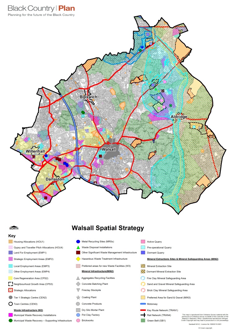
Figure 20 - Walsall strategic centre and AAP boundary
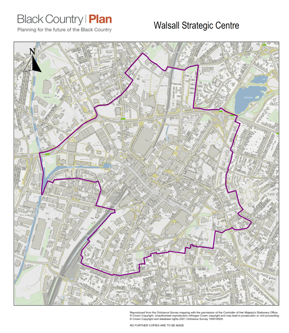
General Spatial Strategy
C.17 Policy CSP1 describes the development strategy for the Black Country as a whole, with growth and regeneration focussed into the Strategic Centres and Core Regeneration Areas as outlined in policy CSP2. Outside these locations, policy CSP3 states that the quality of the Existing Neighbourhood Areas will be protected and enhanced, and a limited number of Neighbourhood Growth Areas in highly sustainable locations on the edge of the Urban Areas will be delivered. These areas in Walsall are described below.
(1) Walsall Strategic Centre
C.18 Walsall Strategic Centre is the administrative, commercial and cultural heart of the borough. It is the focus for a wide range of civic, retail, cultural and leisure functions, including being home to the Town Hall and Civic Centre, County and Magistrates Courts, Walsall College, Waterfront, Crown Wharf and the New Art Gallery. The location is highly accessible by public transport, through the provision of increasingly well-integrated rail and bus services. It lies at the centre of the Walsall to Wolverhampton Core Growth Area.
C.19 In the context of this strategy, and the evidence and opportunities outlined above, the priority for Walsall Town Centre for 2039 is to become a diversified, repurposed and rejuvenated strategic centre, providing a focus for a well-balanced mix of commercial, business, service and community uses spanning the daytime and nigh-time economy. Changing shopping patterns and challenges to the high street will be addressed through increased flexibility, facilitating the consolidation of the shopping core and opening space up to new uses, flexible models of operation and reducing vacancies., This flexibility in the shopping core will be complemented by surrounding office and leisure-led mixed uses, and supported by maximising residential provision in all locations (including the use of upper floors) and with it the services, community functions and educational amenity and accessibility that residents need. The character and quality of the town centre's built and natural environment will be improved to make the town centre a sustainable, healthy and attractive place to shop, live, work and visit.
C.20 The existing strategy for the strategic centre compromises the Unitary Development Plan (2005) and Area Action Plan (AAP) (2019). The UDP, while largely superseded by subsequent Development Plan Documents (including the Black Country Core Strategy and the Walsall Site Allocations Document), still contains saved policies that apply to the Strategic Centre of Walsall, namely Part 1 5.4 - 5.11, Part 2 5.12 - 5.24, Policy S1, Policy S2, Policy S3, Policy S4 and affects developments outside of centres through saved paragraphs and policies 5.41, Policy S6, Policy S7 as well as other general centres Policies S8 - S17. The AAP identifies several areas for investment and targeted use, including St Matthew's Quarter, Walsall Gigaport, Walsall Waterfront and Park Street Shopping Core, with an associated set of policies and proposals for each one. All AAP policies are relevant to proposals within the BCP boundary of Walsall Strategic Centre.
(1) District Centre
C.21 Walsall has five District Centres, Aldridge, Bloxwich, Brownhills, Darlaston and Willenhall, as outlined in BCP Policy CEN1. The district centres serve more localised roles, providing substantial retail, leisure and services to a wide area. Their main role is to meet the needs of their districts for convenience goods, local services and community facilities, although they all have some importance for comparison shopping and in accommodating facilities of Borough-wide importance which cannot be located in Walsall Town Centre.
C.22 The priority for District Centres in 2039 will be to help drive forward the growth and regeneration of the borough outside of the strategic centre as a hub for their respective district areas, providing an enhanced level of town centres uses and services for residents in the district while strengthening connections to the town centre and the outlying local centres and residential areas on the urban fringe. District Centres will be more adaptable and flexible, accommodating housing provision where possible to improve vibrancy and the health of the centre, and offer the most sustainable areas well served by public transport links and a wide array of uses and services. Darlaston and Willenhall lie within the Walsall to Wolverhampton Core Growth Area: they will serve as centres for targeted investment in infrastructure delivery and employment land to help deliver strengthened links between the Black Country's strategic centres. Aldridge, Bloxwich and Brownhills will serve nearby Neighbourhood Growth Areas.
Local Centres
C.23 Walsall has 34 local centres as listed in BCP Policy CEN1. This network of vibrant Local Centres provides particularly for day-to-day convenience shopping and service needs both within the Core Regeneration Areas and Existing Neighbourhood Areas. Within these areas the retention, enhancement and further development of shops, services and other town centre uses is the key aim, with housing supported where it can complement and not prejudice the main town centre uses. Local centres are important to the vitality of Walsall. These centres generally meet day-today convenience goods needs and are especially useful to the elderly and less mobile. They also provide a focal point for the communities within Walsall and are an important part of the Borough's character.
C.24 The priority for Local Centres in 2039 is their protection from the loss of provision to the communities that rely on them, ensuring retention of a good level of access to local convenience and comparison retail, services, community facilities and other amenities. Improved connections through the Neighbourhood Growth Areas will ensure communities continue to be sustainable, with a range of services to support residents' local needs.
C.25 The existing strategy for Local Centres includes the SAD, which outlines policies and allocations for all areas in Walsall outside of the strategic centre and district centres, namely SLC1 and SLC2 which detail plans to strengthen Local Centres.
(25) Walsall to Wolverhampton Core Growth Area
C.26 The Walsall to Wolverhampton Core Regeneration Area is based around the road, rail and waterway corridor, with the Black Country Route linked to M6 Junction 10, the re-opened railway stations at Darlaston and Willenhall, and the Wyrley and Essington Canal which provides a pedestrian, cycle and leisure route from Birchills, through Walsall Strategic Centre, Phoenix 10 and Darlaston to Moxley. Much regeneration has already taken place in this area, and many new homes and jobs are expected to be delivered in the future at key locations such as Phoenix 10, Bentley Lane, Moxley Tip and in Willenhall Town Centre. The Core Regeneration Area will continue to be the focus of public sector investment to regenerate brownfield sites.
(1) Existing Neighbourhood Areas
C.27 Outside the strategic centre and growth areas, existing commitments for new homes and employment will continue to be delivered. The neighbourhood areas provide a network of sustainable residential areas, including some new housing sites of medium size, as well as clusters of employment areas, a network of green infrastructure and community facilities, with seamless links to the strategic centres, Core Regeneration Areas and the Green Belt. It is also expected that small scale housing developments will continue to come forward in the neighbourhood areas as windfalls.
(8) Neighbourhood Growth Areas
C.28 The existing growth network does not have the capacity to accommodate all our need for new homes and jobs. It is also important to safeguard the character of the existing neighbourhood areas, which are often low to medium density housing with good quality open space. A number of Neighbourhood Growth Areas are therefore proposed in sustainable locations close to the existing urban area that have good access to services. These areas will provide for additional homes and jobs to meet the needs of our residents. They will also provide for new or enhanced services where necessary, and in most cases, developers will be required to enhance biodiversity through the provision of new areas for wildlife and the restoration of existing ones.
(9) Green Belt
C.29 Policy CSP3 states that a strong Green Belt will continue to be retained to promote urban renaissance and to provide easy access to the countryside for urban residents where the landscape, nature conservation and agricultural land will be protected and enhanced. Walsall contains the bulk of Green Belt land in the Black Country, compromising over one third of the borough. Walsall's Green Belt is mainly agricultural.
(26) Growth Targets
Table 30 - Walsall growth targets for housing and employment land allocations
|
Location |
Housing (net homes) |
Employment Land allocations |
|
Neighbourhood Growth Areas |
5,418 (to 2039) |
36ha |
|
Core Regeneration Area |
2,126 |
88ha |
|
Walsall Strategic Centre |
1,168 |
n/a |
|
Towns and Neighbourhood Areas |
3,177 |
40ha |
|
Windfalls |
1,455 |
n/a |
|
Total |
13,344 |
164ha |
C.30 The figures in this table are the numbers that are expected to be capable of delivery during the period of the plan. Proposals that will result in the numbers of homes or employment land exceeding the figures will be supported where they are in accordance with the other policies of the development plan.
|
Table 31 - Walsall Sites Allocated for Housing by Black Country Plan (policy HOU1) |
|||||||||
|
Site Ref |
Policy in Previous Local Plan |
Site Name and Address |
Growth Area |
Indicative Housing Capacity |
Gross Site area (ha) |
Indicative net developable area (ha) |
Net Density (dph) |
Anticipated Delivery Timescale |
Further Information |
|
WAH230 |
GB1 |
Land on the east side of Chester Road, Aldridge |
Neighbourhood Growth Area. |
66 |
5.09 |
2.55 |
35 |
Between 2027-2028 |
See Strategic Allocation Policy WSA.9. |
|
WAH231 |
GB1 |
Land off Sutton Road, Longwood Lane, Walsall |
Neighbourhood Growth Area. |
202 |
11.9 |
7.74 |
35 |
Between 2027-2031 |
See Strategic Allocation Policy WSA.6. |
|
WAH232 |
GB1 |
Yieldsfield Farm (sometimes recorded as Yieldfields farm), Stafford Road, Bloxwich |
Neighbourhood Growth Area. |
978 |
39.55 |
37.26 |
35 |
600 by 2039 |
See Strategic Allocation Policy WSA.4. |
|
WAH233 |
GB1 |
Middlemore Lane West, Aldridge |
Neighbourhood Growth Area. |
35 |
1.35 |
1.35 |
35 |
By 2027 |
A strategy for landscape and ecology that ensures the retention and / or mitigation for established trees. Footpath improvements along Middlemore Lane to provide safe and secure access routes. On-site provision or funding for off-site arrangements to improve access to a primary school and local health centre. |
|
WAH234 |
GB1 |
Land between Queslett Road, Doe Bank Lane and Aldridge Road, Pheasey |
Neighbourhood Growth Area. |
1426 |
42.27 |
42.27 |
45 |
960 by 2039 |
See Strategic Allocation Policy WSA8. |
|
WAH235 |
GB1 |
Home Farm, Sandhills, Walsall Wood |
Neighbourhood Growth Area. |
1417 |
54 |
54 |
35 |
800 by 2039 |
See Strategic Allocation Policy WSA1. |
|
WAH236 |
GB1 |
Land at Yorks Bridge, Lichfield Road, Pelsall |
Neighbourhood Growth Area. |
580 |
21.41 |
17.21 |
45 |
Between 2027-2039 |
See Strategic Allocation Policy WSA5. |
|
WAH237 |
GB1 |
Land north of Stonnall Road, Aldridge |
Neighbourhood Growth Area. |
363 |
13.82 |
13.82 |
35 |
Between 2027-2034 |
See Strategic Allocation Policy WSA3. |
|
WAH238 |
GB1 |
Land at Vicarage Road / Coronation Road, High Heath |
Neighbourhood Growth Area. |
504 |
32.11 |
19.22 |
35 |
400 by 2039 |
See Strategic Allocation Policy WSA.2. |
|
WAH239 |
GB1 |
Land north of Northfields Way, Clayhanger, Brownhills |
Neighbourhood Growth Area. |
46 |
1.87 |
1.37 |
45 |
By 2027 |
A satisfactory strategy for enhancement mitigation and compensation for ecology will be required. |
|
WAH240 |
GB1 |
Land at Mob Lane, High Heath, Pelsall |
Neighbourhood Growth Area. |
209 |
7.99 |
7.99 |
35 |
Between 2027-2031 |
See Strategic Allocation Policy WSA.2. |
|
WAH241 |
GB1, ENV7 |
Former NHS site, land east of Nether Hall Avenue, Great Barr |
Neighbourhood Growth Area. |
18 |
1.43 |
0.71 |
35 |
By 2025 |
Site access must be from Stewards Drive. Landscaping scheme to include details of tree protection and retention. The site is in a MSA and requires prior extraction where practical and environmentally feasible. Where practical and environmentally feasible prior extraction for bedrock sand and gravel, shall take place. |
|
WAH242 |
GB1 |
Calderfields West, Aldridge Road, Walsall |
Neighbourhood Growth Area. |
592 |
22.48 |
18.6 |
35 |
442 by 2039 |
See Strategic Allocation Policy WSA.7. |
|
WAH243 |
GB1 |
Cartbridge Lane South Open Space |
Neighbourhood Growth Area. |
61 |
1.81 |
1.81 |
45 |
By 2027 |
The site is in a MSA and requires prior extraction where practical and environmentally feasible. Where practical and environmentally feasible prior extraction for superficial sand and gravel, shall take place. On-site provision or funding for off-site arrangements to improve access to a health centre. |
|
WAH244 |
OS1 |
Former Reedswood Golf Course |
Towns and Neighbourhood Area. |
94 |
5.6 |
2.8 |
45 |
Between 2027-2028 |
Part of reclaimed former power station. Landscaping scheme to include details of tree protection and retention. |
|
WAH245 |
OS1 |
Former Allens Centre and Hilton Road amenity greenspace |
Towns and Neighbourhood Area. |
23 |
2.10 |
0.71 |
45 |
By 2025 |
Redundant open space. Only 0.71 ha of the submitted area to the west is allocated. |
|
WAH246 |
GB1 |
Land to the east of Chester Road, north of Pacific Nurseries Hardwick |
Neighbourhood Growth Area. |
228 |
8.69 |
8.69 |
35 |
Between 2030-2034 |
See Strategic Allocation Policy WSA9. |
|
WAH247 |
GB1 |
Sandfield Farm, Lichfield Road, Brownhills |
Neighbourhood Growth Area. |
33 |
1.27 |
1.27 |
35 |
By 2027 |
High quality design to provide for single storey accommodation is required. The site is in a MSA and requires prior extraction where practical and environmentally feasible. Where practical and environmentally feasible prior extraction for bedrock sand and gravel, shall take place. On-site provision or funding for off-site arrangements to improve access to a primary school and local health centre. |
|
WAH248 |
GB1 |
Land to the northeast of Shire Oak, Lichfield Road |
Neighbourhood Growth Area. |
10 |
0.37 |
0.37 |
35 |
By 2027 |
The site is in a MSA and requires prior extraction where practical and environmentally feasible. Where practical and environmentally feasible prior extraction for bedrock and superficial sand and gravel, shall take place. Development of the site must be in conjunction with Sandfield Farm development to ensure sustainability. |
|
WAH249 |
GB1 |
Land to the southwest of Shire Oak, Lichfield Road |
Neighbourhood Growth Area. |
8 |
0.32 |
0.32 |
35 |
By 2027 |
The site is in a MSA and requires prior extraction where practical and environmentally feasible. Where practical and environmentally feasible prior extraction for bedrock, sand and gravel will take place. Development of the site must be in conjunction with Sandfield Farm development to ensure sustainability. |
|
WAH250 |
GB1 |
Star Service Station, Queslett Road East |
Neighbourhood Growth Area. |
53 |
0.27 |
0.27 |
45 |
By 2022 |
Former Green Belt site with planning permission for flats. |
|
WAH251 |
GB1 |
212 Barns Farm, Barns Lane |
Neighbourhood Growth Area. |
112 |
4.26 |
4.26 |
45 |
Between 2027-2029 |
A satisfactory strategy for enhancement mitigation and or compensation for ecology which takes account of the adjacent SLINC. Investigation and remediation of contaminated land. The site is in a MSA and requires prior extraction where practical and environmentally feasible. Where practical and environmentally feasible prior extraction for superficial sand and gravel, brick clay shall take place. Mitigation including consideration of acceptable layout to ensure no significant amenity impacts from the operation of Atlas Quarry. On-site provision or funding for off-site arrangements to improve access to a health centre. |
|
WAH252 |
GB1 |
The Three Crowns, Sutton Road |
Towns and Neighbourhood Area. |
7 |
0.7 |
0.7 |
35 |
By 2022 |
Brownfield site in green belt with existing planning permission. A satisfactory strategy for enhancement mitigation and or compensation for ecology. |
|
WAH253 |
GB1 |
South of Stonnall Road |
Neighbourhood Growth Area. |
38 |
5.07 |
4.45 |
35 |
Between 2032-2033 |
Investigation and remediation of contaminated land. Footpaths required to serve the development and provision for a controlled / uncontrolled pedestrian crossing on Stonnall Road. The site is in a MSA and requires prior extraction where practical and environmentally feasible. Where practical and environmentally feasible prior extraction for bedrock sand and gravel, shall take place. On-site provision or funding for off-site arrangements to improve access to a primary school and local health centre. |
|
WAH254 |
GB1 |
Pacific Nurseries, Chester Road, Walsall |
Neighbourhood Growth Area. |
121 |
4.65 |
2.09 |
35 |
Between 2029-2031 |
Investigation and remediation of contaminated land. Established trees worthy of protection shall be retained and could reduce the developable area. The site is in a MSA and requires prior extraction where practical and environmentally feasible. Where practical and environmentally feasible prior extraction for bedrock and superficial sand and gravel, shall take place. . On-site provision or funding for off-site arrangements to improve access to primary school, secondary school and local health centre. |
|
WAH255 |
GB1 |
Rear of 91 Wood Lane, Streetly |
Neighbourhood Growth Area. |
49 |
2.33 |
1.7 |
35 |
By 2026 |
Established trees worthy of protection shall be retained and could reduce the developable area. The site is in a MSA and requires prior extraction where practical and environmentally feasible. Where practical and environmentally feasible prior extraction for bedrock and superficial sand and gravel, shall take place. On-site provision or funding for off-site arrangements to improve access to a primary school. |
|
WAH256 |
GB1 |
Land to the rear of 114-130 Green Lane, Shelfield |
Neighbourhood Growth Area. |
37 |
1.91 |
1.41 |
35 |
By 2026 |
Landscaping scheme to include details of tree protection and retention. The site is in a MSA and requires prior extraction where practical and environmentally feasible. Where practical and environmentally feasible prior extraction for superficial sand and gravel, shall take place. |
|
Table 32 - Walsall Sites Allocated for Housing 'Carried Forward' from Site Allocation Document |
|||||||||
|
Site Ref |
Policy in Previous Local Plan |
Site Name and Address |
Growth Area |
Indicative Housing Capacity |
Gross Site area (ha) |
Indicative Net Developable Area (ha) |
Net Density (dph) |
Anticipated Delivery Timescale |
Further Information |
|
WAH001 |
HC1 |
New Road (former car showroom), Willenhall |
9 |
0.27 |
by 2026 |
Residential development to north and south. Site may be affected by underground power cable: see National Grid / Western Power comments |
|||
|
WAH002 |
HC1 |
Field Street (Gilberts' Club), Willenhall |
26 |
0.77 |
by 2026 |
Potential to enlarge UDP allocated site to include all or part of this area as part of Willenhall district centre development |
|||
|
WAH003 |
HC1 |
Kendrick Place and Castle View Road, Moxley |
25 |
0.73 |
by 2026 |
Surplus Walsall Council land. Boundary amended and capacity revised to exclude area with planning permission |
|||
|
WAH005 |
HC1 |
Goscote Lane Copper Works, Goscote |
263 |
8.76 |
by 2026 |
Large site in housing renewal area. Reclamation work is underway. SAD allocation is for 395 but capacity reduced to match latest planning application |
|||
|
WAH006 |
HC1 |
Bentley Road North (corner of King Charles Avenue), Bentley |
23 |
0.34 |
by 2026 |
Cleared former social housing site. Potential to develop with similar site immediately to north. |
|||
|
WAH007 |
HC1 |
Joynson Street (site of former Kings Hill JMI School), Darlaston |
17 |
0.49 |
by 2026 |
Surplus Walsall Council property. Planning permission for nursing home but suitable for conventional dwellings if this is not implemented. Add lapsed pp area to west |
|||
|
WAH008 |
HC1 |
Adjoining 15 Joynson Street, Darlaston |
5 |
0.08 |
by 2026 |
Lapsed planning permission. Site too small to allocate by itself but lies adjacent to much larger housing sites |
|||
|
WAH009 |
HC1 |
Riding Way, Short Heath |
14 |
0.40 |
by 2026 |
Part is surplus Council property. Inaccessible and little used open space |
|||
|
WAH010 |
HC1 |
Hatherton Liberal Club, North Street, Walsall |
6 |
0.18 |
by 2026 |
Need to consider potential for housing in conjunction with adjoining sites |
|||
|
WAH011 |
HC1 |
Mill Street, (former scrap yard), Walsall |
12 |
0.34 |
by 2026 |
Need to consider potential for housing in conjunction with adjoining sites |
|||
|
WAH012 |
HC1 |
Watling Street (land north of Kings Deer Road), Brownhills |
15 |
0.21 |
by 2026 |
Vacant site adjacent to recently completed housing development. |
|||
|
WAH013 |
HC1 |
Poplar Avenue (east), Bentley |
23 |
0.63 |
by 2026 |
||||
|
WAH014 |
HC1 |
Noose Crescent (former Lakeside School), Willenhall |
59 |
1.71 |
by 2026 |
Surplus school site owned by Walsall Council |
|||
|
WAH015 |
HC1 |
Rear of 16 High Road, Lane Head, Willenhall |
29 |
0.84 |
by 2026 |
Garage and open storage area. Site lies in residential area. Housing recently completed on former church site to north-east. Site enlarged to include former site 348 |
|||
|
WAH016 |
HC1 |
30 to 32 Hollyhedge Lane (east side)), Walsall |
33 |
0.29 |
by 2026 |
||||
|
WAH017 |
HC1 |
28 Hollyhedge Lane (east side) (), Walsall |
24 |
0.21 |
by 2026 |
||||
|
WAH018 |
HC1 |
former Bradford Coal Wharf, Hollyhedge Lane (east side) , Walsall |
52 |
0.45 |
by 2026 |
||||
|
WAH019 |
HC1 |
Orange Tree, 20 Wolverhampton Road, Walsall |
4 |
0.03 |
by 2026 |
Estimated dwelling capacity based on numbers proposed in planning application 07/0196/FL/W7 divided pro-rata across application site. Suitability for residential subject to air quality being acceptable |
|||
|
WAH020 |
HC1 |
Former Metal Casements, Birch Street, Walsall |
95 |
2.71 |
by 2026 |
Developability depends on treatment of limestone workings |
|||
|
WAH021 |
HC1 |
Hollyhedge Lane (west side), Walsall |
14 |
0.39 |
by 2026 |
||||
|
WAH022 |
HC1 |
Walsall Iron and Steel, Wolverhampton Road, Walsall |
67 |
0.48 |
by 2026 |
Potential to develop in conjunction with adjoining former Harvestime |
|||
|
WAH023 |
HC1 |
Festival Avenue (end of street), Darlaston |
10 |
0.31 |
by 2026 |
Surplus open space. |
|||
|
WAH024 |
HC1 |
Festival Avenue, Darlaston |
24 |
0.68 |
by 2026 |
Surplus Open Space. Formerly playing field for now demolished school. |
|||
|
WAH025 |
HC1 |
Woodwards Road (former garage and vehicle storage yard), Walsall |
24 |
0.37 |
by 2026 |
||||
|
WAH026 |
HC1 |
New Invention Methodist Church, Lichfield Road, New Invention |
14 |
0.42 |
by 2026 |
Former church in residential area. |
|||
|
WAH027 |
HC1 |
Allen's Centre, Hilton Road, New Invention |
22 |
0.64 |
by 2026 |
Surplus council property. Allocation relates to building footprint only, not adjacent open space |
|||
|
WAH028 |
HC1 |
Essington Lodge, Essington Road, New Invention |
23 |
0.66 |
by 2026 |
Potential surplus Walsall Council property |
|||
|
WAH030 |
HC1 |
60, Walsall Road, Willenhall, Walsall |
24 |
0.39 |
by 2026 |
Lapsed planning permission for residential development. In use as car parking for adjacent temple |
|||
|
WAH031 |
HC1 |
1 and 2 Fletchers Lane, Willenhall |
2 |
0.05 |
by 2026 |
allocate for housing in conjunction with adjoining sites |
|||
|
WAH032 |
HC1 |
3 Fletchers Lane, Willenhall |
3 |
0.06 |
by 2026 |
Lapsed planning permission. Allocate for housing with adjoining sites |
|||
|
WAH033 |
HC1 |
ASK Motors, 664 Bloxwich Road, Walsall |
20 |
0.15 |
by 2026 |
Lapsed planning permission. Site currently in use for car sales but lies in predominantly residential area |
|||
|
WAH034 |
HC1 |
British Lion Works, Forest Lane, Walsall |
16 |
0.23 |
by 2026 |
capacity reduced in line with latest permission |
|||
|
WAH035 |
HC1 |
British Lion Works, Forest Lane, Walsall |
3 |
0.07 |
by 2026 |
Residual area covered by SAD housing allocation. Estimated capacity based on 40dph |
|||
|
WAH036 |
HC1 |
Eagle Public House, Creswell Crescent, Bloxwich |
17 |
0.12 |
by 2026 |
Lapsed planning permission for apartments. Adjacent to rail station and frequent bus service so suitable for high density residential development despite adjacent development only comprising houses |
|||
|
WAH040 |
HC1 |
Former Works Site c/o Cemetery Road, Villiers Street, Willenhall |
14 |
0.16 |
by 2026 |
potential for development in conjunction with adjacent sites and as part of Willenhall district centre |
|||
|
WAH043 |
HC1 |
Howdles Lane / Castle Street, Brownhills |
40 |
1.19 |
by 2026 |
Site boundary amended from UDP allocation to match boundary with Gladstone House and exclude access to Howdles Lane garages |
|||
|
WAH044 |
HC1 |
Gladstone House, 45 Castle Street, Brownhills |
6 |
0.18 |
by 2026 |
Too small to allocate in SAD by itself, but add to adjoining UDP allocation site (HO168a) |
|||
|
WAH045 |
HC1 |
Land adjacent Bentley Green, Bentley Road North, Walsall |
144 |
0.78 |
by 2026 |
||||
|
WAH046 |
HC1 |
Land at Churchill Road and Kent Road, to the rear of 2-14 Kent Road and 201-205 Churchill Road, Bentley, Walsall |
26 |
0.92 |
by 2026 |
Site boundary and housing capacity based on outline planning permission. Part of site is within SLINC. Sewer beneath part of site |
|||
|
WAH048 |
HC1 |
Bentley Moor Club, Bentley Drive, Walsall |
10 |
0.27 |
by 2026 |
lapsed planning permission but site remains clear and available |
|||
|
WAH049 |
HC1 |
Lichfield Road, Little Bloxwich |
10 |
0.29 |
by 2026 |
Part of UDP allocation has been developed. Remainder of site is currently in use as community transport base |
|||
|
WAH050 |
HC1 |
Petrol Station, 274 - 276 Lichfield Road, Willenhall |
21 |
0.51 |
by 2026 |
Lapsed planning permission. Site remains in use as petrol station but surrounding area is residential, so this would be preferred alternative use |
|||
|
WAH051 |
HC1 |
Rear of Pinson Road, Willenhall |
15 |
0.40 |
by 2026 |
Potential to enlarge site to include land to east and north as part of Willenhall district centre development |
|||
|
WAH053 |
HC1 |
Former Petrol Station corner of Bentley Mill Way, Wolverhampton Road West, Walsall |
21 |
0.10 |
by 2026 |
Lapsed planning permission. Potential to be added to adjoining former Pickfords Site IN91.4 but housing in conjunction with Lane Arms PH site more feasible |
|||
|
WAH054 |
HC1 |
Former Lane Arms Public House, corner of Bentley Road North, Wolverhampton Road West, Walsall |
12 |
0.24 |
by 2026 |
||||
|
WAH055 |
HC1 |
Between 114 and 120 and 122a and 127 Watling Street/ Roman Close, Brownhills |
10 |
0.29 |
by 2026 |
Surplus Walsall Council land. |
|||
|
WAH056 |
HC1 |
Cricket Close allotments and tennis courts, Walsall |
42 |
1.22 |
by 2026 |
||||
|
WAH057 |
HC1 |
Former Royal Navy Club, 120 Elmore Green Road, Bloxwich |
10 |
0.10 |
by 2026 |
lapsed permission but site remains vacant and available |
|||
|
WAH058 |
HC1 |
Gordon House (TA Centre), Sutton Road, Walsall |
22 |
0.63 |
by 2026 |
Potential surplus Government property |
|||
|
WAH059 |
HC1 |
Narrow Lane House and Neighbourhood Office Site, Narrow Lane, Walsall |
14 |
0.48 |
by 2026 |
Surplus Walsall Council property. Boundary revised 29-03-18 following completion of junction improvement |
|||
|
WAH060 |
HC1 |
Pleck Working Men's Club, Pleck Road, Walsall |
11 |
0.24 |
by 2026 |
Lapsed planning permission. Site has been cleared and in use for temporary car parking |
|||
|
WAH061 |
HC1 |
Royal British Legion Club, Broad Lane Gardens, Bloxwich |
25 |
0.71 |
by 2026 |
Surplus Walsall Council property |
|||
|
WAH063 |
HC1 |
Former Warreners Arms, High Street, Brownhills |
58 |
0.36 |
by 2026 |
Capacity based on planning application but this has been withdrawn |
|||
|
WAH065 |
HC1 |
Birway Garage, Newhall Street, Willenhall |
28 |
0.33 |
by 2026 |
allowed on appeal 6/1/15 |
|||
|
WAH066 |
HC1 |
Willenhall Coachcraft, 348 Wolverhampton Road West, Willenhall |
33 |
0.62 |
by 2026 |
Long established car sales use at front of site but remainder is vacant |
|||
|
WAH067 |
HC1 |
Rowley View, Moxley (former nursery and open space) |
15 |
0.43 |
by 2026 |
Former Rowley View Nursery |
|||
|
WAH068 |
HC1 |
Rowley View, Moxley (Former Highgate Arms) |
11 |
0.17 |
by 2026 |
Former Highgate Arms Pub. |
|||
|
WAH069 |
HC1 |
Gorway Road |
25 |
1.65 |
by 2026 |
Future of site needs to be considered in conjunction with remainder of Wolverhampton University site. Still potential for housing, but impact on woodland needs to be addressed |
|||
Table 33 - Walsall Sites Allocated for Permanent Gypsy and Traveller Sites by Black Country Plan
|
Policies |
Site Ref |
Policy in Previous Local Plan |
Site Name and Address |
Appropriate Uses |
Indicative Development Capacity (housing and employment land) |
Site area (ha) |
Anticipated Delivery Timescale |
Further Information |
|
HOU4 |
WAGT019 |
GB1 |
56 Cartbridge Lane |
Travellers |
4 pitches |
0.27ha |
Immediate |
Existing occupied site in Green Belt with temporary planning permission that lapsed in 2016 |
|
HOU4 |
WAGT020 |
GB1 |
34-38 Gould Firm Lane |
Travellers |
4 pitches |
0.20ha |
Immediate |
Existing occupied site in Green Belt with personal permission |
Table 34 - Walsall Sites allocated for permanent Gypsy and Traveller sites carried forward from Site Allocation Document
|
Policies |
Site Ref |
Policy in Previous Local Plan |
Site Name and Address |
Appropriate Uses |
Indicative Development Capacity (housing and employment land) |
Site area (ha) |
Anticipated Delivery Timescale |
Further Information |
|
HOU4 |
WAGT001 |
HC4, GB1 |
Willenhall Lane Caravan Site, Willenhall Lane, Bloxwich (Former Community Room) |
Travellers |
2 pitches |
n/a |
2024 |
Additional pitches on existing local authority site through redevelopment of former community room |
|
HOU4 |
WAGT002 |
HC4 |
Rear of 48 - 72 Foster Street, Blakenall |
Travellers |
3 pitches |
n/a |
2024 |
Existing allocation |
|
HOU4 |
WAGT003 |
HC4 |
Dolphin Close (Goscote Site C), Goscote |
Travellers |
10 pitches |
n/a |
2024 |
Existing allocation on local authority owned land |
|
Table 35 - Walsall Existing Traveller Sites Safeguarded for Current Use and Carried Forward from Site Allocation Document |
||||||||
|
Policies |
Site Ref |
Policy in Previous Local Plan |
Site Name and Address |
Appropriate Uses |
Indicative Development Capacity (housing and employment land) |
Site area (ha) |
Anticipated Delivery Timescale |
Further Information |
|
HOU4 |
WAGT018 |
HC4, GB1 |
Willenhall Lane Caravan Site, Willenhall Lane, Bloxwich |
Travellers |
19 pitches |
|
|
|
|
HOU4 |
WAGT005 |
HC4 |
Haywoods, Noose Lane, Willenhall |
Travellers |
1 pitch |
|||
|
HOU4 |
WAGT004 |
HC4 |
Trentham Cottage, Noose Lane, Willenhall |
Travellers |
11 pitches |
|||
|
HOU4 |
WAGT006 |
HC4 |
47A Guild Avenue, Bloxwich |
Travellers |
1 pitch |
|||
|
HOU4 |
WAGT007 |
HC4, GB1 |
Railswood Nursery, Railswood Drive, Pelsall |
Travellers |
1 pitch |
|||
|
HOU4 |
WAGT016 |
HC4 |
Adjacent 1 Croft Street, Willenhall |
Travellers |
1 pitch |
|||
|
HOU4 |
WAGT012 |
HC4, GB1 |
Bridge Farm, Goscote Lane, Bloxwich |
Showpeople |
12 plots |
|||
|
HOU4 |
WAGT011 |
HC4, GB1 |
Oak Tree Farm, Goscote Lane, Bloxwich |
Showpeople |
9 plots |
|||
|
HOU4 |
WAGT010 |
HC4, GB1 |
Goscote Lane (Storage Yard), Bloxwich |
Showpeople |
0 (storage area) |
|||
|
HOU4 |
WAGT009 |
HC4, GB1 |
Showmen's Guild Site, Goscote Lane, Bloxwich |
Showpeople |
20 plots |
|||
|
HOU4 |
WAGT013 |
HC4, GB1 |
East of Goscote Lane (Strawberry Fields), Bloxwich |
Showpeople |
1 plot |
|||
|
HOU4 |
WAGT014 |
HC4 |
Lindon Road, Brownhills |
Showpeople |
1 plot |
|||
|
HOU4 |
WAGT017 |
HC4 |
Toberland, Reaymer Close, Walsall |
Showpeople |
14 plots |
|||
|
HOU4 |
WAGT015 |
HC4 |
Charlie Swann, 110 Lindon Road, Brownhills |
Showpeople |
9 plots |
|||
Table 36 - Walsall Sites Allocated for Employment by Black Country Plan (policy EMP1)
|
BCP Site Ref |
Policy in previous local plan |
Site Name and Address |
Indicative development capacity (ha employment land) |
Gross site area (ha) |
Anticipated delivery timescale |
Further Information |
|
WAE409 |
GB1 |
237 Watling Street, Brownhills |
5.92 |
5.92 |
By 2039 |
Neighbourhood Growth Area |
|
WAE404 |
GB1 |
Lynx / Beatwaste Site, Bentley Lane |
11.22 |
11.2 |
By 2039 |
Former landfill site in green belt. Investigation and remediation of contaminated land. |
|
WAE410 |
GB1 |
Johnsons Farm and Meadow Farm |
8.41 |
8.41 |
By 2039 |
Neighbourhood Growth Area. Footpaths are required to serve the development along Lichfield Road and Hanney Hay Road. The site is in a MSA and requires prior extraction where practical and environmentally feasible. Where practical and environmentally feasible prior extraction for bedrock sand and gravel, shall take place. |
|
WAE411 |
GB1 |
Land to the south east of Longwood Bridge |
1.3 |
1.3 |
By 2039 |
Neighbourhood Growth Area adjacent to Aldridge Airport industrial area. Established trees worthy of protection shall be retained and could reduce the developable area. |
|
WAE412 |
GB1 |
Sandown Quarry, Stubbers Green Road, Aldridge |
20.85 |
20.85 |
By 2039 |
Currently active quarry that will need to be infilled and stabilised before development. Landscaping scheme required in the interests of local amenities and ecology. The site is in a MSA and requires prior extraction where practical and environmentally feasible. Where practical and environmentally feasible prior extraction for superficial sand and gravel, brick clay shall take place. |
|
Table 37 - Walsall Sites Allocated for Employment 'Carried Forward' from Site Allocation Document |
||||||
|
BCP Site Ref |
Policy in Previous Local Plan (replaced unless stated) |
Site Name and Address |
Indicative Development Capacity (ha employment land) |
Gross Site area (ha) |
Anticipated Delivery Timescale |
Further Information |
|
WAE002 |
IND3 |
Pelsall Road / Bullows Road, Brownhills |
1.51 |
|||
|
WAE005 |
IND2 |
North of Maybrook / Clayhanger Road, Brownhills |
1.79 |
|||
|
WAE004 |
IND3 |
Former scrapyard, north of Joberns Tip, Coppice Lane, Walsall Wood |
1.91 |
|||
|
WAE007 |
IND3 |
Longleat Road, Walsall Wood (south of Focus Car Park) |
0.19 |
|||
|
WAE009 |
IND3 |
Land corner of Northgate / Longleat Road, Aldridge |
0.62 |
|||
|
WAE010 |
IND2 |
Adjacent Shaylors, Anchor Industrial Park, Wharf Approach, Aldridge |
0.95 |
|||
|
WAE012 |
IND2 |
Former Aldridge Rail Sidings, Middlemore Lane, Aldridge |
2.16 |
|||
|
WAE014 |
IND2 |
Former Jack Allen Site, South of Middlemore Lane, Aldridge |
1.87 |
|||
|
WAE021 |
IND2 |
McKechnie Brass, Middlemore Lane, Aldridge |
6.34 |
|||
|
WAE017 |
IND3 |
Focus 10 (adjacent former Trident Alloys), Willenhall Lane, Bloxwich |
5.92 |
|||
|
WAE024 |
IND3 |
Fryers Road, Bloxwich |
3.82 |
|||
|
WAE018 |
IND3 |
Rear of Biasi House, opposite Mary Elliot School, Leamore Lane |
0.55 |
|||
|
WAE027 |
IND2 |
Former Calor Gas Site fronting Green Lane, Walsall |
1.01 |
|||
|
WAE041 |
IND2 |
North of Newfield Close, Walsall |
2.19 |
|||
|
WAE032 |
IND3 |
Former scrap yard, Alma Street, Walsall |
0.51 |
|||
|
WAE052 |
IND2 |
Walsall Enterprise Park West, Regal Drive, Pleck |
0.79 |
|||
|
WAE056 |
IND2 |
Adjacent to Middletons, Bescot Crescent |
0.43 |
|||
|
WAE058 |
IND2 |
Reedswood Way |
4.02 |
|||
|
WAE063 |
IND2 |
Tempus 10 North (land east of KFC, Tempus Drive) |
1.76 |
|||
|
WAE064 |
IND2 |
Tempus 10 South (land south of Village Hotel, Tempus Drive) |
1.64 |
|||
|
WAE068 |
IND3 |
Land between St. Annes Road, Monmer Lane and Sharesacre Street, Willenhall |
2.57 |
|||
|
WAE065 |
IND3 |
Adjacent Rainbow Business Park, Stringes Lane, Willenhall |
0.45 |
|||
|
WAE069 |
IND3 |
Former Ductile, Charles Street, Willenhall |
2.59 |
|||
|
WAE070 |
IND2 |
Aspray (Former George Carter Pressings), Park Road, Willenhall |
1.24 |
|||
|
WAE076 |
IND3 |
Land rear of Guardian Lock and 47 Wednesfield Road, Willenhall |
0.39 |
|||
|
WAE071 |
IND3 |
North of Watery Lane, Willenhall |
0.63 |
|||
|
WAE072 |
IND3 |
Rear of Assa Abloy, School Street, Willenhall |
2.24 |
|||
|
WAE076 |
IND2 |
Rear of 18 Rose Hill, Willenhall |
0.3 |
|||
|
WAE078 |
IND2 |
North of Westacre, Willenhall |
0.64 |
|||
|
WAE084 |
IND2 |
Central Point, Willenhall Road, Darlaston |
1.67 |
|||
|
WAE093 |
IND2 |
Axcess 10 Business Park, land adjacent Unit 401, Bentley Road South |
1.03 |
|||
|
WAE099 |
IND2 |
Heath Road / Kendricks Road, Darlaston |
0.41 |
|||
|
WAE103 |
IND3 |
Former IMI south of canal, Darlaston Road, Pleck (Phoenix 10 Site A - Part) |
0.84 |
|||
|
WAE104 |
IND2 |
Former IMI Works, Pleck (Phoenix 10 Site A - part) |
9.45 |
|||
|
WAE106 |
IND2 |
North of IMI, Pleck (Phoenix 10 Site B) |
4.09 |
|||
|
WAE105 |
IND2 |
Rear of Globe Pub, Darlaston Road, Walsall |
2.89 |
|||
|
WAE109 |
IND2 |
Box Pool Site, Darlaston Road, Walsall |
1.67 |
|||
|
WAE110 |
IND2 |
James Bridge Gasholders Site, Darlaston Road, Walsall |
8.22 |
|||
|
WAE118 |
IND2 |
Rear of Woods Bank Trading Estate, Woden Road West, Darlaston |
1.2 |
|||
|
WAE120 |
IND2 |
Moxley Junction, Moxley |
0.48 |
|||
|
WAE122 |
IND5 |
Former Moxley Tip, Moxley Road |
10.38 |
|||
|
WAE205 |
IND2 |
Bentley Mill Way East (Phoenix 10 Site C) |
2.4 |
|||
|
WAE315 |
IND5 |
Casino and Cinema, Bentley Mill Way |
4.58 |
|||
|
WAE317 |
IND5 |
Millers Close, Bentley Mill Way |
0.82 |
|||
|
WAE328 |
IND3 |
Leamore Lane (south side - former Dealeys Castings) |
2.54 |
|||
|
WAE333 |
IND5 |
Willenhall Sewage Works |
8.9 |
|||
|
WAE341 |
IND5 |
Hughes Road, Moxley |
4.37 |
|||
Strategic Allocations
C.31 The following strategic allocations are large sites that are significant in size and that have specific development considerations. Decisions on planning applications for these sites should be made in accordance with the specific policy requirements listed in this document.
C.32 For each site where the allocation includes housing, an indicative site capacity is provided. The precise number of homes to be developed will be determined through the planning application process.
Aldridge North & Walsall Wood
(91) Policy WSA1 (Walsall Strategic Allocation) – Home Farm, Sandhills, Walsall Wood
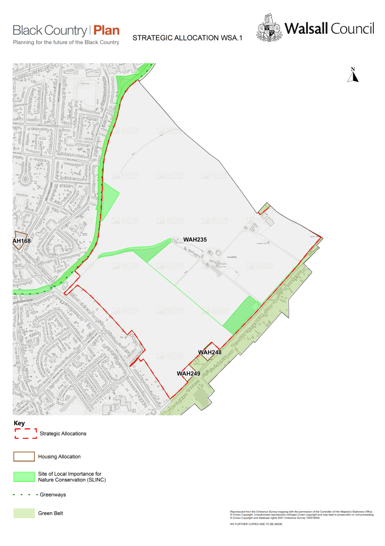
General introduction
C.33 Home Farm is located on the northern boundary of Walsall with Lichfield. The northwest boundary is defined by the Wyrley and Essington Canal, with housing beyond and industrial uses to the far northwest corner. The northeast boundary follows the boundary to Lichfield District with more land in agricultural use beyond. The southwest boundary meets the rear garden boundaries to houses on Chester Road. The southeast boundary meets the Lichfield Road with houses on the opposite side.
C.34 The developable area is 54 hectares.
C.35 The estimated capacity of the site is 1435 houses.
C.36 Mixed tenure housing is suitable on the site, with higher densities of at least 35dph and affordable housing provision.
Design principles:
- Deliver appropriate local facilities to support the new residents and to enhance the sustainability of the existing area, including a new primary school and local health centre.
- Investigation and detailed proposals for remediation of contaminated land.
- A transport strategy that includes:
- unconnected access to and from the site along Chester Road and Lichfield Road;
- necessary capacity mitigation and improvements to the junction at Lichfield Road and Chester Road;
- provides a new traffic light junction between Lindon Road and Chester Road; and
- provides opportunities for bus routes to serve the development.
- Enhanced provision for pedestrians and cyclists, including enhanced connectivity with the district centre.
- Develop a site-wide Sustainable Drainage Strategy to ensure that drainage requirements can be met on site and are designed to deliver landscape, biodiversity and amenity benefits.
- A strategy for landscape and habitat creation that provides enhancement, retention and mitigation for established trees and hedges, to ensure there is no significant adverse impact on visual amenity and character or on protected animal species
- The site is in a MSA and requires prior extraction where practical and environmentally feasible. Where practical and environmentally feasible prior extraction for bedrock and superficial sand and gravel, shall take place.
(201)
Policy WSA2 – Land at Vicarage Road and Coronation Road, High Heath and land at Mob Lane, Pelsall
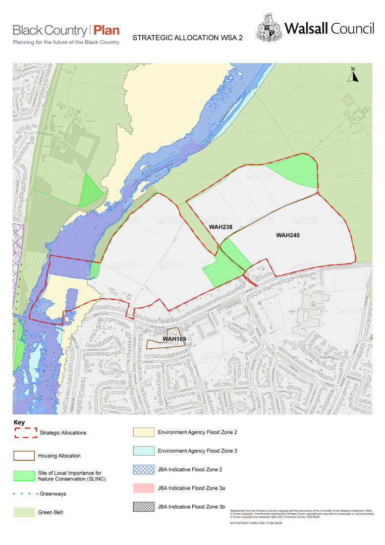
General introduction
C.37 Land at Vicarage Road and Coronation Road and land at Mob Lane is located along the northern urban edge of High Heath. To the north are fields with Pelsall and Clayhanger urban areas beyond, to the east fields and a sewage works, to the south is proposed allocation WSA3, High Heath and an area of housing that is characterised by predominantly traditional semi-detached houses, and to the west is Pelsall and a former railway line.
C.38 The developable site area is 30.19ha.
C.39 The estimated capacity of the site is 713 houses.
C.40 Mixed tenure housing is suitable with higher densities of at least 35dph and affordable housing provision.
Design principles:
- Deliver appropriate local facilities to support the new residents and to enhance the sustainability of the existing area, including a new primary school and local health centre.
- Investigation of and detailed proposals for the remediation of contaminated land.
- A transport strategy that includes improvements to Mob Lane and Green Lane.
- A site-wide Sustainable Drainage Strategy, to ensure that drainage requirements can be met on site and that is designed to deliver landscape, biodiversity and amenity benefits.
- A strategy for landscape and habitat creation that provides enhancement, retention and / or mitigation for established trees and hedges, to ensure there are no significant adverse impacts on visual amenity and character or on protected animal species.
- The site is in a MSA and requires prior extraction where practical and environmentally feasible. Where practical and environmentally feasible prior extraction for bedrock and superficial sand and gravel, shall take place.
(112) Policy WSA3 – Land north of Stonnall Road, Aldridge
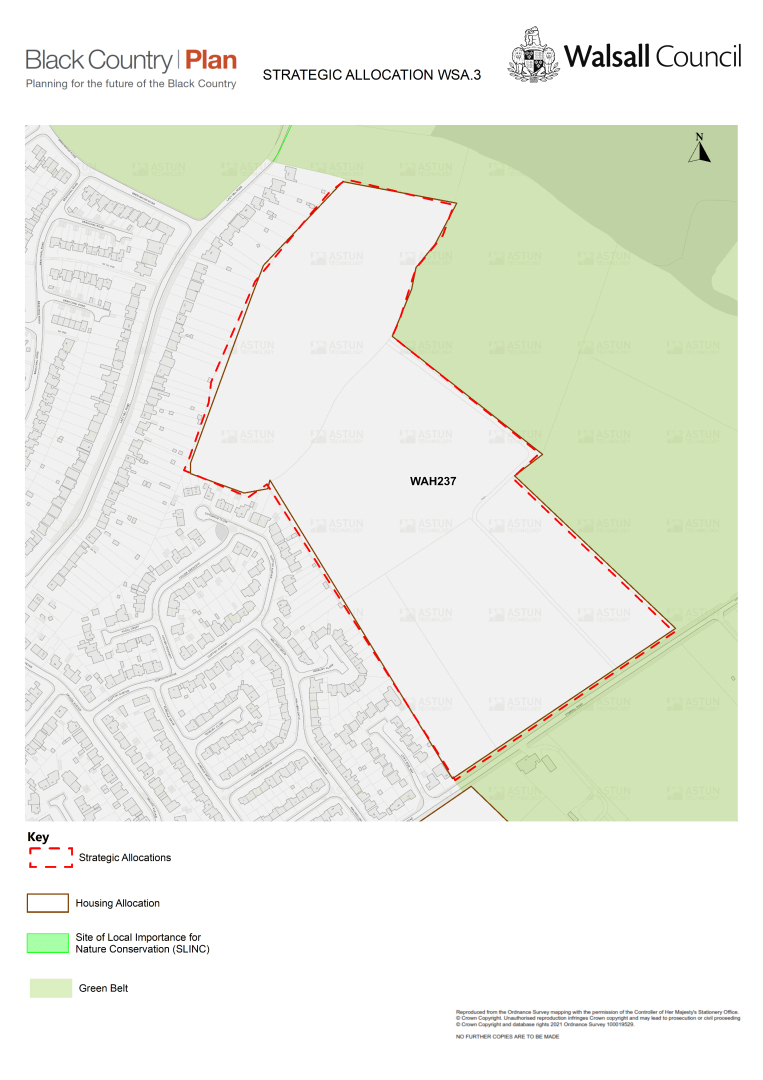
General introduction
C.41 Land north of Stonnall Road is located along the eastern urban edge of Aldridge. To the north are houses; to the east agricultural fields; to the south is proposed allocation WAH253 and agriculture beyond; and to the west are houses. The predominant character of houses here are a mix of detached bungalows and houses, modern but traditionally styled.
C.42 The estimated capacity of the site is 13.82ha.
C.43 The site is proposed to be allocated for 363 houses.
C.44 Mixed tenure housing is suitable, with higher densities of at least 35dph and affordable housing provision.
Design principles:
- Improvements to local facilities, to support residents and to enhance the sustainability of the existing area, in particular improved capacity at the primary school and local health centre.
- Investigation of and detailed proposals for remediation of contaminated land.
- A transport strategy that includes widening to Stonnall Road for the extent of the site allocation and improves pedestrian access.
- Develop a site-wide Sustainable Drainage Strategy to ensure that drainage requirements can be met on site and are designed to deliver landscape, biodiversity and amenity benefits.
- Develop a strategy for landscape and habitat creation that provides enhancement, retention and mitigation for established trees and hedges, to ensure there is no significant adverse impact on visual amenity and character or on protected animal species.
- The site is in a MSA and requires prior extraction where practical and environmentally feasible. Where practical and environmentally feasible prior extraction for bedrock and superficial sand and gravel, shall take place.
Bloxwich East
(36) Policy WSA4 – Yieldsfield Farm (sometimes recorded as Yieldfields farm), Stafford Road, Bloxwich
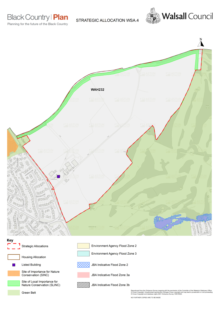
General introduction
C.45 Yieldsfield Farm is located along the northern urban edge of Bloxwich. To the north are fields with Newtown and Landywood beyond in South Staffordshire District. To the east lie fields and to the south is Bloxwich Golf Course. To the west is the Turnberry housing estate, composed of predominantly modern, traditionally styled detached houses. Within this site is Yieldsfield Hall, a Grade II listed building.
C.46 The developable site area is 26ha.
C.47 The estimated capacity of the site is 978 houses.
C.48 Mixed tenure housing is suitable on the site with higher densities of at least 35dph and affordable housing provision.
Design principles:
- High quality, sensitive design and layout that conserves and enhances the setting and significance of Yieldsfield Hall, a Grade II listed building; this must be informed by a detailed heritage character assessment for the proposal.
- Delivery of appropriate local facilities to support residents and to enhance the sustainability of the existing area, including a new primary, school and local health centre.
- Contribution to improvements for secondary school provision in North Bloxwich.
- Investigation and detailed proposals for remediation of contaminated land.
- A transport strategy that includes new crossing points on the A34 and a new vehicular junction to serve the development.
- A site-wide Sustainable Drainage Strategy, to ensure that drainage requirements can be met on site and are designed to deliver landscape, biodiversity and amenity benefits.
- A strategy for landscape and habitat creation that provides enhancement, retention and mitigation for established trees and hedges, to ensure there is no significant adverse impact on visual amenity and character, in particular that might be experienced from the north and west, and to ensure there is no significant adverse impact on protected animal species.
Pelsall
(121) Policy WSA5 – Land at Yorks Bridge, Lichfield Road, Pelsall
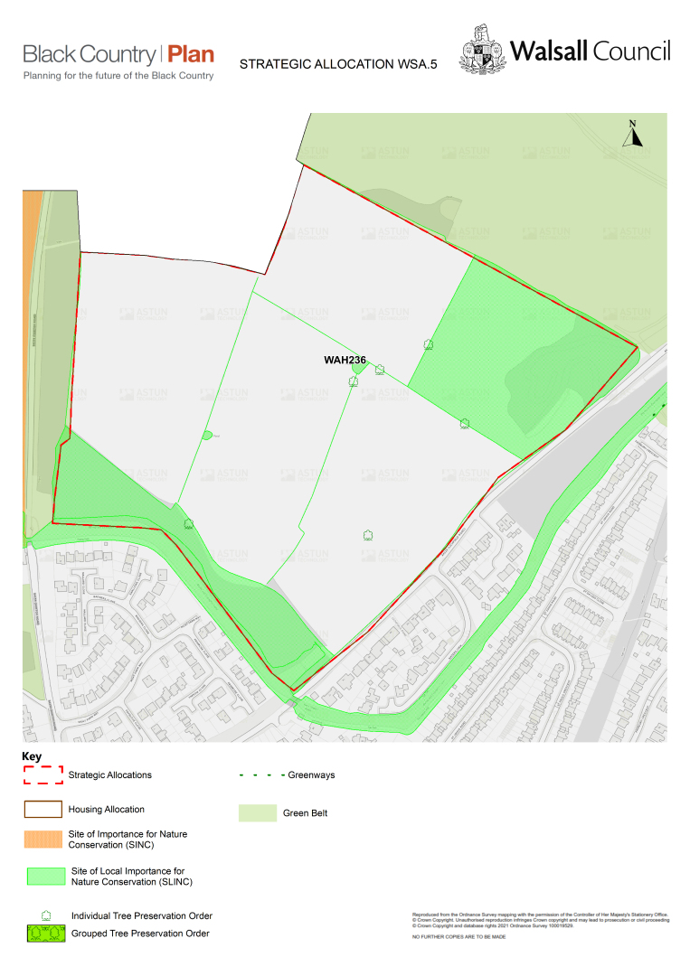
General introduction
C.49 Yorks Bridge is located on the northern urban edge of Pelsall, along the border with Cannock Chase District. To the north are fields with Norton Canes the nearest urban area beyond in Cannock. To the east lie fields; to the south and west is residential development, predominantly modern, traditionally-styled detached houses. The site contains ten protected trees and a SLINC to the east.
C.50 The developable site area is 13.47ha.
C.51 The estimated capacity of the site is 580 houses.
C.52 Mixed tenure housing is suitable with higher densities of at least 35dph and affordable housing provision.
Design principles:
- Delivery of appropriate local facilities to support residents and to enhance the sustainability of the existing area, including a new primary school and local health centre.
- Investigation and detailed proposals for the remediation of contaminated land.
- A transport strategy that includes the widening of Lichfield Road to allow for a ghost turn into the site, and which includes necessary capacity mitigation and improvements to the junction at Lichfield Road, Wolverhampton Road, Lime Lane and Walsall Road.
- A site-wide Sustainable Drainage Strategy, to ensure that drainage requirements can be met on site and are designed to deliver landscape, biodiversity and amenity benefits whilst protecting existing SLINC designated areas.
- A strategy for landscape and habitat creation, which provides enhancement, retention and mitigation for protected and established trees and hedges, to ensure there is no significant adverse impact on ecology, biodiversity, visual amenity and character and protected animal species.
Pheasey Park Farm
(153) Policy WSA6 – Land off Sutton Road, Longwood Lane, Walsall
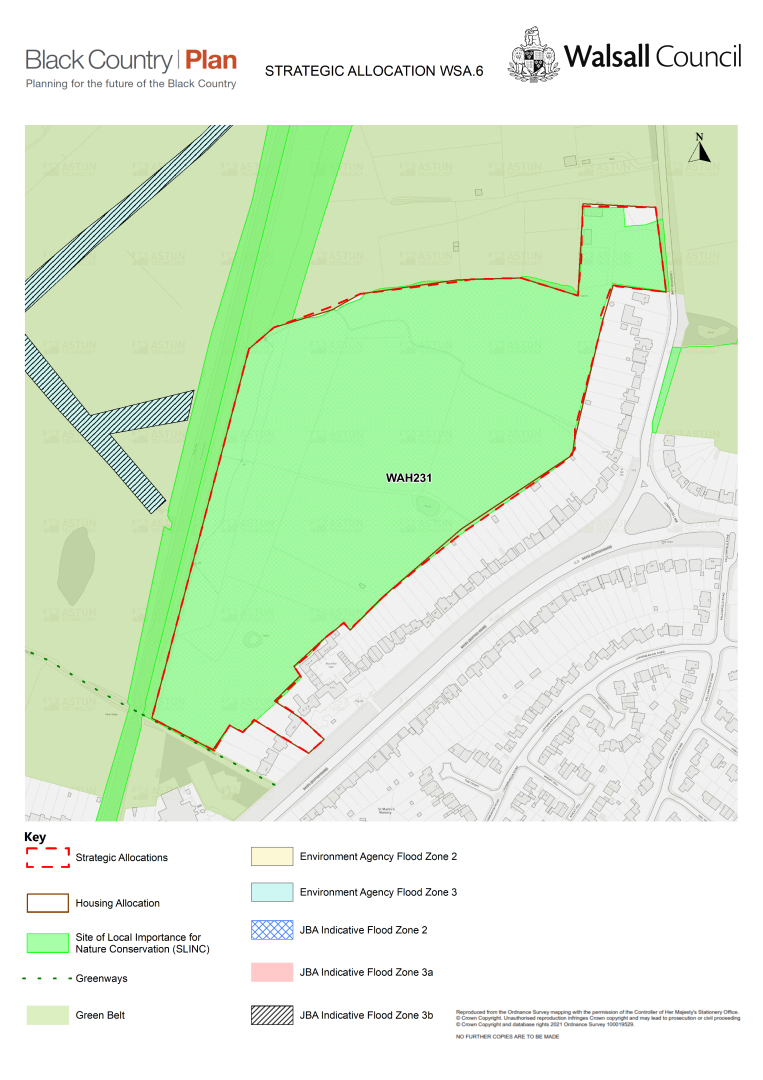
General introduction
C.53 Land off Sutton Road, Longwood Lane is located along the very northern part of Pheasey Park Farm. To the north are fields, to the east and south are houses and to the west is the canal with Arboretum Park beyond it. The character of the immediate area is defined by predominantly traditionally-styled detached houses. The site has recently been designated a SLINC.
C.54 The developable site area is 7.74ha.
C.55 The estimated capacity of the site is 202 houses.
C.56 Mixed tenure housing is suitable in this location, with higher densities of at least 35dph and affordable housing provision.
Design principles:
- Improvements to local facilities, to support residents and to enhance the sustainability of the existing area, in particular improved capacity at the primary school and local health centre.
- Investigation of and detailed proposals for the remediation of contaminated land.
- A transport strategy that includes single access onto Sutton Road, and which ensures that the transport impacts of the development are appropriately managed and mitigated.
- Enhanced provision for pedestrians and cyclists, including enhanced connectivity with cycle route CR012.
- A site-wide Sustainable Drainage Strategy to ensure that drainage requirements can be met on site and that are designed to deliver landscape, biodiversity and amenity benefits, which also takes full account of existing watercourses.
- A strategy for landscape and habitat creation that provides enhancement, retention and mitigation for existing SLINC features and established trees, to ensure there is no significant adverse impact on ecology, biodiversity, visual amenity and character or on protected animal species.
St Matthews
(156) Policy WSA7 – Calderfields West, Land at Aldridge Road, Walsall
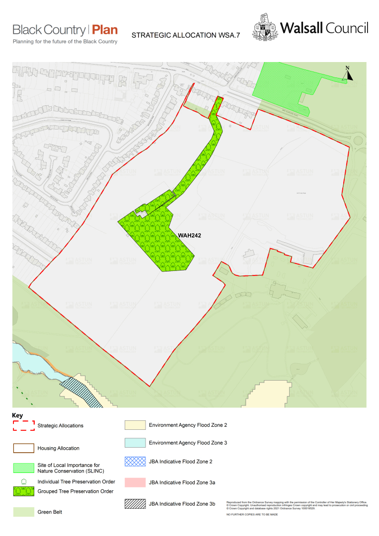
General introduction
C.57 The site at Calderfields West, on land at Aldridge Lane, is located along the eastern urban edge of St. Mathews. To the north are fields, to the east is Calderfields Golf Club, to the south is the Arboretum and to the west are houses. The character of the area is a mix of traditional and modern styled detached houses. Within the developable site area is Calderfields Farm, which provides seven existing barn conversion properties with gated access from Aldridge Road.
C.58 The developable site area is 18.6ha.
C.59 The estimated capacity of the site is 592 houses.
C.60 Mixed tenure housing is suitable with higher densities of at least 35dph and affordable housing provision.
Design principles:
- Deliver appropriate local facilities to support the new residents and to enhance the sustainability of the existing area, including a new primary school and local health centre.
- Investigation and detailed proposals for the remediation of contaminated land.
- A transport strategy that ensure that the transport impacts of the development are appropriately managed and mitigated.
- Enhanced provision for pedestrians and cyclists, including enhanced connectivity with the town centre.
- A site-wide Sustainable Drainage Strategy, to ensure that drainage requirements can be met on site and are designed to deliver landscape, biodiversity and amenity benefits.
- A strategy for landscape and habitat creation, in particular along the southern boundary to the Arboretum, providing new tree planting to ensure there is no significant adverse impact on the visual amenity and character of the Arboretum, nor on protected animal species.
Streetly
(248) Policy WSA8 – Land between Queslett Road, Doe Bank Lane and Aldridge Road, Pheasey
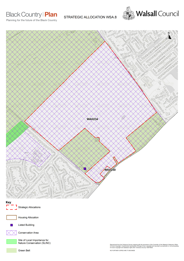
General introduction
C.61 Land between Queslett Road, Doe Bank Lane and Aldridge Road is made up of fields between the Pheasey Estate and Streetly. To the north are agricultural fields, to the east, south and west lies housing. The site surrounds Doe Bank Lane Farmhouse and farm buildings to the west, which are Grade II listed.
C.62 The developable site area is 42.27ha.
C.63 The estimated capacity of the site is 1426 houses.
C.64 Mixed tenure housing is suitable with higher densities of at least 35dph and affordable housing provision.
Design principles:
- High quality, sensitive design and layout that conserves and enhances the setting and significance of Doe Bank Lane Farmhouse and farm buildings, which are Grade II listed buildings; this must be informed by a detailed heritage character assessment undertaken for the proposal.
- Deliver appropriate local facilities to support the new residents and to enhance the sustainability of the existing area, including a new primary school and local health centre..
- Investigation and detailed proposals for remediation of contaminated land.
- A transport strategy that ensures that the transport impacts of the development are appropriately managed and mitigated.
- A site-wide Sustainable Drainage Strategy, to ensure that drainage requirements can be met on site and designed to deliver landscape, biodiversity and amenity benefits.
- A strategy for landscape and habitat creation that provides enhancement, retention and mitigation for established trees and hedges, to ensure there is no significant adverse impact on visual amenity and character, nor on protected animal species.
- The site is in a MSA and requires prior extraction where practical and environmentally feasible. Where practical and environmentally feasible prior extraction for bedrock and superficial sand and gravel, shall take place.
(61) Policy WSA9 – Land to the east of Chester Road, north of Pacific Nurseries, Hardwick
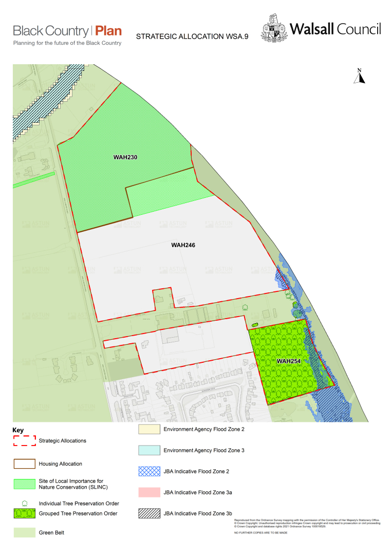
General introduction
C.65 Land to the east of Chester Road (WAH230), north of Pacific Nurseries (WAH246) and Pacific Nurseries (WAH254) are a cluster of three sites, currently used for a mix of agriculture, horse grazing and a garden centre; to the east is a railway line with a golf course beyond it; to the south lies the urban edge of Streetly; and to the west are agricultural fields.
C.66 The developable site area is 13.33ha.
C.67 The estimated capacity of the site is 415 houses.
C.68 Mixed tenure housing is suitable with higher densities of at least 35dph and affordable housing provision.
Design principles:
- Deliver appropriate local facilities to support the new residents and to enhance the sustainability of the existing area, including a new primary school and local health centre.
- Investigation and detailed proposals for remediation of contaminated land.
- A transport strategy that ensures the transport impacts of the development are appropriately managed and mitigated.
- Enhanced provision for pedestrians and cyclists, including enhanced connectivity with the local centre.
- A site-wide Sustainable Drainage Strategy, to ensure that drainage requirements can be met on site and that is designed to deliver landscape, biodiversity and amenity benefits.
- A strategy for landscape and habitat creation which provides enhancement, retention and mitigation for established trees, to ensure there is no significant adverse impact on visual amenity and character nor on protected animal species.
- The site is in a MSA and requires prior extraction where practical and environmentally feasible. Where practical and environmentally feasible prior extraction for bedrock and superficial sand and gravel, shall take place.
Waste
Strategic Waste Management Sites
C.69 The existing strategic sites identified on the Waste Key Diagram are the significant waste management facilities operating in the Black Country. They have been identified through a detailed analysis of all known licenced and exempt facilities in each authority area.
C.70 Under Policy W2 (Waste Sites), the BCA will safeguard all existing strategic and other waste management facilities from inappropriate development, in order to maintain existing levels of waste management capacity and meet Strategic Priority 13.
C.71 The strategic waste management sites within Walsall Borough are listed in the following table:
|
Table 38 - Strategic Waste Management Sites in Walsall |
|||
|
BCP Site Ref |
Walsall SAD Site Ref |
Site Name and Address |
Operational Capacity (tpa) |
|
Total Landfill Capacity (tonnes)[10] |
|||
|
Municipal Waste Recovery Installations |
|||
|
WS02 |
WS9 |
Aldridge MRF (Biffa)[11], Westgate Aldridge |
150,000 |
|
Municipal Waste Recovery – Supporting Infrastructure |
|||
|
WS09 |
WS8 |
Fryers Road WTS, Bloxwich |
100,000 |
|
WS10 |
WS8 |
Fryers Road HWRC, Bloxwich |
12,000 |
|
WS11 |
WS14 |
Merchants Way HWRC, Aldridge |
10,000 |
|
WS12 |
WS19 |
Walsall Council Environmental Depot, Brownhills |
2,700 |
|
Waste Disposal Installations |
|||
|
WS18 |
WS10 |
Highfields South Landfill, Walsall Wood |
130,000 |
|
928,000 |
|||
|
Significant Hazardous Waste Treatment Infrastructure |
|||
|
WS20 |
WS6 |
Empire Treatment Works, Aldridge |
100,000 |
|
Significant Metal Recycling Sites (MRSs) |
|||
|
WS29 |
W17 |
Chas B Pugh, Heath Road, Darlaston |
18,000 |
|
WS30 |
W21 |
ELG Haniel Metals, Heath Road, Darlaston |
30,000 |
|
WS31 |
WS05 |
EMR Darlaston, Bentley Road South |
260,000 |
|
WS32 |
W62 |
Scanmetals (UK) Ltd, Bilston Lane, Willenhall |
56,000 |
|
WS33 |
W77 |
Tandom Metallurgical, Apex Road, Brownhills |
25,000 |
|
Other Significant Waste Management Infrastructure |
|||
|
WS49 |
WS17 |
Bescot Triangle South, Bescot Road |
50,000 |
|
WS50 |
WS03 |
Credential Environmental, Parkway North, Western Way |
40,000 |
|
WS51 |
W76 |
D S Smith Birmingham Depot, Rose Hill Industrial Estate, Willenhall |
20,000 |
|
WS52 |
WS01 |
D E O'Reilly Waste Management[12], Coppice Lane, Aldridge |
40,000 |
|
WS53 |
WS05 |
EMR Darlaston (Fridge Recycling Plant), Bentley Mill Lane, Darlaston |
40,000 |
|
WS54 |
WS04 |
Ecobat Logistics[13], Crescent Works Industrial Estate, Willenhall Road |
25,000 |
|
WS55 |
WS11 |
Veolia Darlaston, Holland Industrial Park, Bentley Road South |
30,000 |
|
WS56 |
W16 |
Central Waste Oil Collections, Premier Business Park, Queen Street |
35,000 |
Sources: Environment Agency: Waste Data Interrogator (WDI) 2007 – 2018, Operational Incinerators, 2018, Public Register, Remaining Landfill Capacity in England as at end of 2018 Version 2.
Preferred Areas for New Waste Facilities
C.72 A number of employment areas have been identified in the Black Country Waste Study (BCWS) as being most suited to the development of new waste recovery, waste treatment and waste transfer infrastructure.
C.73 Under Policy W3 (Preferred Areas for New Waste Facilities), these areas are considered least likely to give rise to land use conflicts, and in several cases, there is already co-location of existing waste facilities to which new sites would contribute.
C.74 There are three such areas in Walsall Borough that are identified on the Waste Key Diagram and listed in the following table:
Table 39 - Walsall Preferred Areas for New Waste Facilities
|
BCP Site Ref |
Walsall SAD Site Ref |
Site name and address |
Area (Ha) |
|
WPwa1 |
IN18.1 IN27 |
Leamore and Newfield Close Industrial Estates, Bloxwich |
80.4 |
|
WPwa2 |
IN88 IN95 IN96 |
Holland Industrial Park / Heath Road and Environs, Darlaston |
52.4 |
|
WPwa3 |
IN67 IN68 |
Ashmore Lake Industrial Estate, Willenhall |
40 |
(4) Minerals
C.75 The Black Country Minerals Study (BCMS, Tables 12.10 and 12.9) lists all known existing mineral sites and mineral infrastructure sites in the Black Country.
C.76 Existing mineral sites within the Black Country include permitted mineral extraction sites, stockpiles, brick and tile works, and a pot clay factory.
C.77 Existing Black Country mineral infrastructure sites include secondary / recycled aggregates production, rail linked aggregates depots, coating plants, ready-mix (RMX) concrete batching plants, manufacture of concrete products, and dry silo mortar (DSM) plants.
C.78 Under Policy MIN2 (Minerals Safeguarding Areas, MSAs), the BCA will safeguard all existing mineral sites and mineral infrastructure sites from inappropriate development – this being necessary in order to retain existing capacity, and thereby helping to make best use of and conserve the Black Country's finite mineral resources and meet Strategic Priority 14.
C.79 The locations of these Black Country mineral sites and mineral infrastructure sites are identified on the Minerals Key Diagram, and those sites located within Walsall Borough are listed in the following tables:
Table 40 - Walsall Mineral Sites
|
BCP Site Ref |
Walsall SAD Site Ref |
Site Name and Address |
Type |
|
MSwa1 |
MB1 |
Aldridge Brickworks, Brick Yard Road, Aldridge |
Brickworks |
|
MSwa2 |
MB2 |
Atlas Brickworks, Stubbers Green Road, Aldridge |
Brickworks |
|
MSwa3 |
MP2 |
Atlas Quarry, 175 Stubbers Green Road, Walsall |
Brick Clay |
|
MSwa4 |
MP3 |
Birch Coppice, Pelsall Rd, Walsall |
Coal and Fireclay |
|
MSwa5 |
MP4 |
Branton Hill Quarry and extension, Branton Hill Lane, Walsall |
Sand |
|
MSwa6 |
MXA2 |
Highfields North, Walsall Road, Walsall |
Brick Clay (dormant permitted minerals site) |
|
MSwa7 |
MP9 |
Land at Brownhills Common, Chester Road North, Brownhills |
Coal and Fireclay (dormant permitted minerals site) |
|
MSwa8 |
MP5 |
Sandown Brickworks, Stubbers Green Road, Aldridge |
Brickworks |
|
MSwa9 |
MB3 |
Sandown Quarry, Stubbers Green Road, Aldridge |
Brick Clay |
|
MSwa10 |
MP7 |
Swan Works, Swan Works, Pelsall Road |
Manufacture and supply of pot clay blends |
Table 41 - Walsall Mineral Infrastructure Sites
|
BCP Site Ref |
Walsall SAD Site Ref |
Site Name and Address |
Type |
|
MIwa1 |
MI4 |
Bescot Triangle South, Off Bescot Road, Walsall |
Aggregates recycling |
|
MIwa2 |
MI2 |
Branton Hill CLEUD Relocation Site, Branton Hill Lane, Walsall |
Aggregates recycling |
|
MIwa3 |
MI3 |
Breedon Walsall Cement and Aggregates Depot, Fairground Way, Walsall |
Rail-linked aggregates depot |
|
MIwa4 |
MI3 |
Breedon Concrete Plant, Fairground Way, Walsall |
Concrete batching plant |
|
MIwa5 |
MI5 |
Express Asphalt, Downs Road, Darlaston |
Coating plant |
|
MIwa6 |
MI16 |
G & B G Morris, Willenhall Industrial Estate, off Eastacre, Willenhall |
Secondary aggregates processing |
|
MIwa7 |
MI17 |
Interserve Site Services, Brickyard Road, Walsall |
Aggregates recycling |
|
MIwa8 |
MI18 |
Concrete Walsall, Fenchurch Close, Walsall |
Tarmac / concrete batching plant |
(52) D. City of Wolverhampton
Introduction
D.1 Wolverhampton is the City of the Black Country, forming the gateway between the West Midlands conurbation and the countryside of Staffordshire and Shropshire. The City has excellent transport connectivity with the sub-region and the rest of the UK. It is well- served by the M54 and M6 motorways and benefits from good public transport links through the Metro, cross-country railway links and in its role as a hub of the sub-regional bus network.
D.2 Wolverhampton is a young, vibrant and diverse City with a population of 263,357 people in 2019. The City covers an area of 69.4sq km and includes the City Centre and the town centres of Bilston and Wednesfield. While the City has the smallest population of the four Black Country local authorities, it is the second most densely-populated, the administrative boundary being very tightly drawn around the urban area. The northern, western and south-western fringes of the City lie within the West Midlands Green Belt, which also extends into the urban area in a series of green 'corridors'.
D.3 There were 103,000 jobs in the City in 2019, concentrated in the City Centre, and a series of employment areas that are home to a wide range of manufacturing and logistics businesses. The City economy has traditional strengths in high-value manufacturing and construction and is also developing clusters in other key sectors while retaining a strong focus on investing in skills. Wolverhampton is home to the University of Wolverhampton, who are investing £100m into the Springfield super-campus – an international centre for urban innovation - and the City of Wolverhampton College and its Science, Technology, Engineering and Mathematics (STEM) orientated academies.
D.4 The City grew initially as a market town, specialising in the wool trade. In the industrial revolution it became a major centre for coal mining, lock-making and subsequently the manufacture of cars and motorcycles. This has created a rich legacy of historic buildings and attractive parks and open spaces. It has a strong sporting, cultural and leisure offer, and is home to Wolverhampton Wanderers Football Club, the Grand Theatre and nationally important Civic Halls concert venue.
D.5 Covid-19 hit the city hard from the earliest and during subsequent waves of the pandemic, exacerbating existing social and economic challenges including lower-than-average earnings, relatively high levels of unemployment and a need to enhance the skills base of the local workforce. But the City is bold and ambitious city and wants to move forward, plan for recovery and 'level up' prosperity for the benefit of the community.
(1) The Strategy
D.6 In the context of the issues and opportunities outlined above, the 2030 Vision for Wolverhampton is for:
'a place where people come from far and wide to work, shop, study and enjoy our vibrant city. It will be transformed while still retaining all of those attributes that give our city its unique identity. A healthy, thriving and sustainable international 'smart city' – renowned for its booming economy and skilled workforce, rich diversity and a commitment to fairness and equality that ensures everyone has the chance to benefit from success.'
D.7 This Plan forms an essential part of this strategy, supporting the re-energising, diversification and re-purposing of the City Centre, supporting the recovery and growth of the economy, and providing for a continuous supply of new homes to meet the needs of local and wider communities. At the same time, the Plan will protect key environmental assets – the green belt, the network of high quality green and blue spaces, and the local character and heritage.
D.8 This Plan supports the delivery of 12,100 new homes and 65ha of employment land to 2039, supporting the growth of the City's population to around 290,000 people and a workforce of 180,000. To plan for this growth, locations that are both sustainable and deliverable have been prioritised in line with the Spatial Strategy set out in Policy CSP1. This growth will be supported by transport investment, focused on enhancing the rail and rapid transit network and the key road corridors and investment in walking and cycling. Development will help to green the City, by increasing tree cover and providing biodiversity net gain and will help to deliver priority environmental improvements to ensure residents have easy access to a range of healthy recreation opportunities. These priorities will include those set out in the emerging Black Country Nature Recovery Network Strategy, Wolverhampton Open Space and Playing Pitch Strategies, and include opportunities to improve the canal network and restore the Bradley Arm Canal Link (as set out in BCAAP Policy BC7).
Figure 21 - City of Wolverhampton Spatial Plan
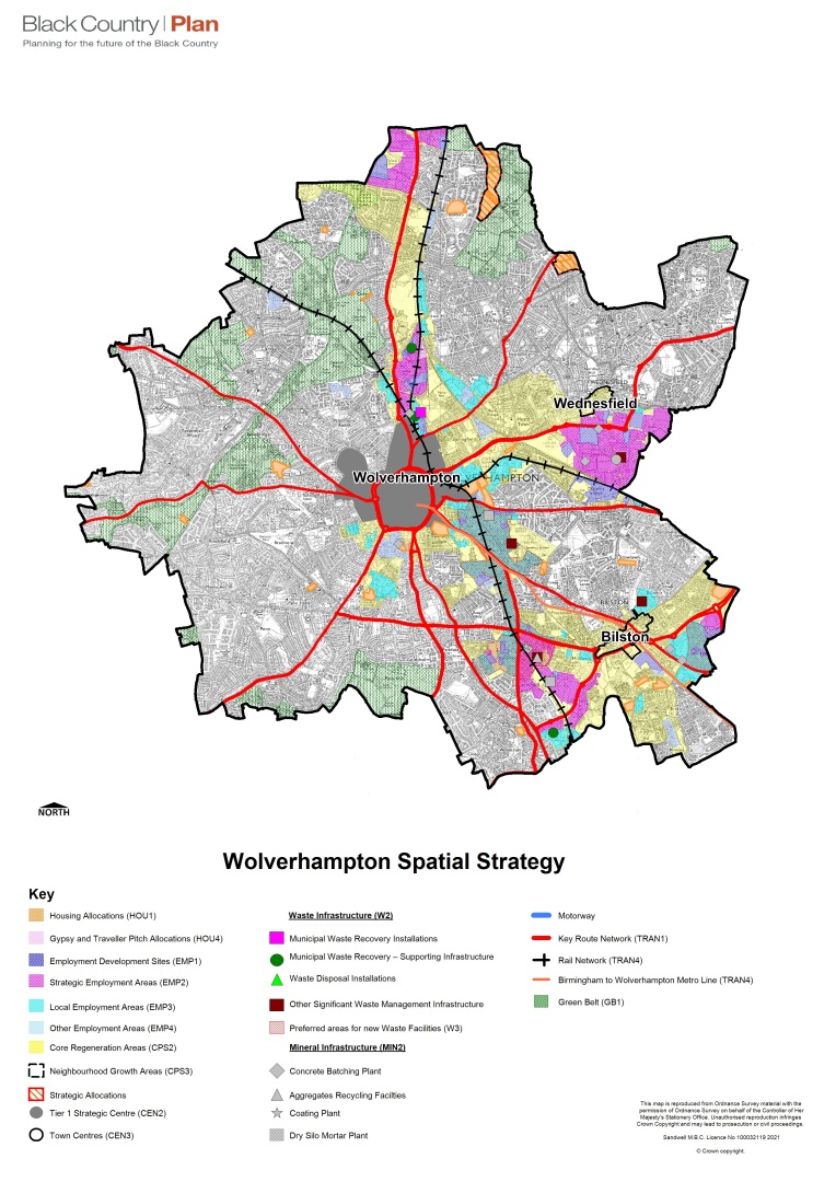
D.9 Development and investment will be focussed on Wolverhampton City Centre and three Core Regeneration Areas as summarised in Table 42.
Table 42 - Wolverhampton Housing and Employment Growth Network
|
Location |
Housing (net homes) |
Employment Land allocations (ha) |
|
Growth Network |
||
|
Wolverhampton City Centre (Wolverhampton Strategic Centre) |
4838 (Sites = 3276; Windfalls = 812; Uplift = 750) |
0.0 |
|
Stafford Road Core Regeneration Area |
395 |
16.8 |
|
Wednesfield Core Regeneration Area |
627 |
26.3 |
|
Bilston Core Regeneration Area |
2285 |
22.9 |
|
Total Growth Network |
8,145 |
66.0 |
|
Towns and Neighbourhoods Area |
||
|
Bushbury Neighbourhood Growth Area |
532 |
0.0 |
|
Fallings Park Neighbourhood Growth Area |
303 |
0.0 |
|
Other Sites in Wolverhampton Towns and Neighbourhoods Area |
1468 |
0.0 |
|
Total Towns and Neighbourhoods Area |
2,303 |
0.0 |
|
Small Windfall Housing Sites (outside Wolverhampton City Centre) |
1652 |
0.0 |
|
Wolverhampton Total |
12,100 |
65.0 |
(3) Wolverhampton City Centre
D.10 Wolverhampton City Centre, as designated on the Policies Map and shown on Figure 21 is the administrative, commercial and cultural heart of the City and in its role as the City of the Black Country. It is the focus for a wide range of civic, retail, cultural and leisure functions. It is a location that is highly accessible by a range of public transport options, including rail, Metro and bus services. The BCP supports the diversification, repurposing and rejuvenation of the City centre, promoting a well-balanced mix of commercial, business and service uses. Changing shopping patterns and other challenges to the traditional high street will be addressed through increased flexibility and by facilitating the consolidation of the shopping core (particularly to reduce vacancy rates), complemented by surrounding office and leisure-led mixed uses, and supported by maximising residential provision in all locations (including the use of upper floors). The character and quality of both the cultural and civic function of the City centre and the built and natural environment will be improved, helping to make the City centre a sustainable, healthy and attractive place to shop, live, work and visit. This will be achieved through BCP policies (particularly CSP2, CEN2 and Environmental Transformation policies), City centre regeneration projects and through more detailed policies in the City Centre Area Action Plan (AAP)
Figure 22 - Wolverhampton Strategic Centre Boundary
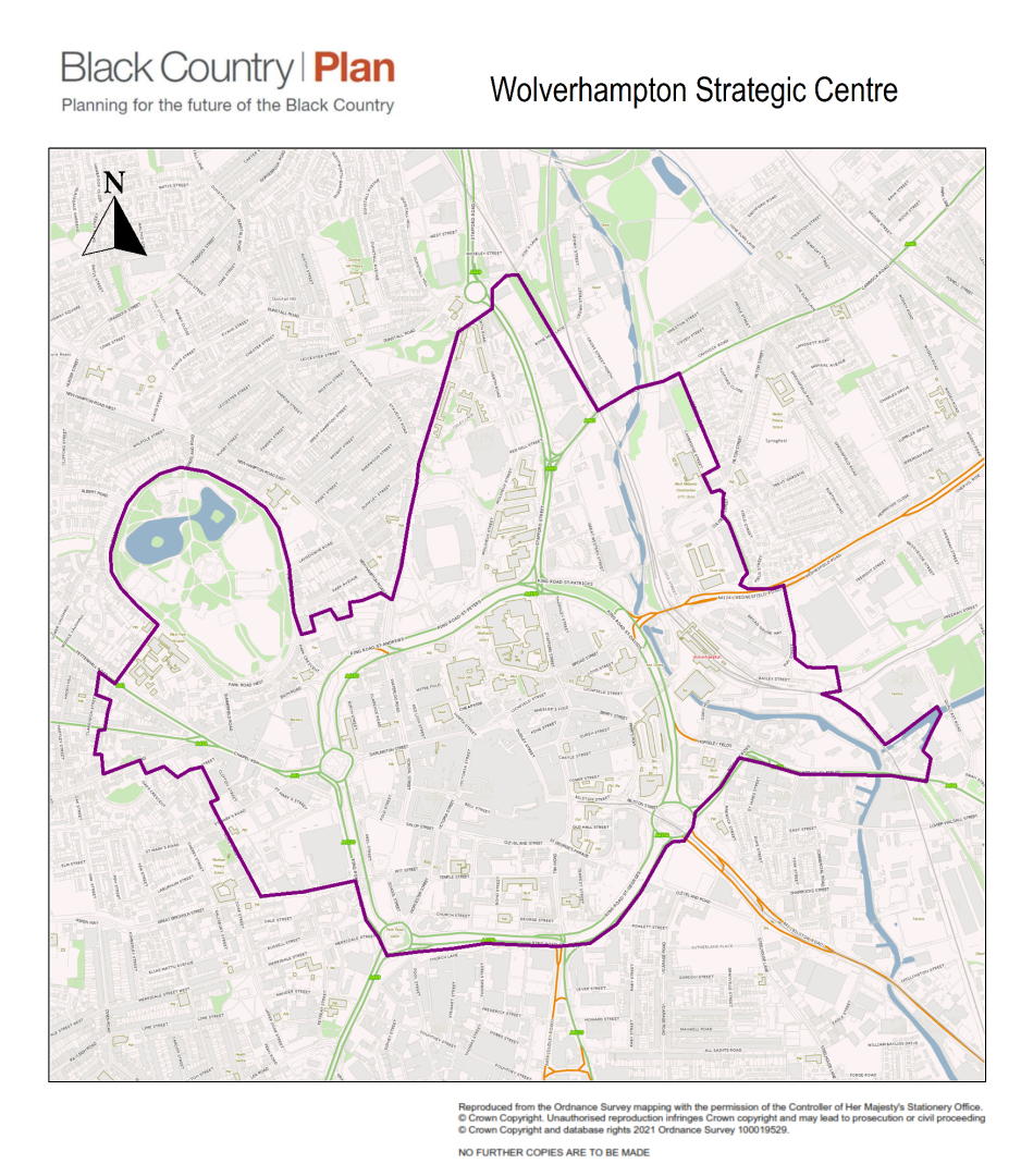
D.11 The Black Country Centres Study advises that the future prosperity of the City centre is predicated on attracting additional footfall. This can be achieved through new residential development, the repurposing of existing vacant space to create and attract interest in, and qualitative improvements to, the leisure offer and associated services. The provision of Grade A offices to focus employment in the centre will also contribute to generating additional footfall. This will build on the strategy of the City Centre AAP, which looked to consolidate the role of the shopping core and encourage complementary activities such as leisure, office and residential uses; and the need for planning 'flexibility' to capture future investment. Regeneration of the City Centre is being delivered through various funding mechanisms and regeneration schemes. For example, the Future High Streets Fund is a £15.7million scheme providing major works that focus on 15ha covering the Victoria Street, Bell Street, Cleveland Street, Fold Street and public realm around the Civic Halls area of the City Centre. This will involve new investment in public realm and events space, helping to boost the evening economy and unlock a wider package of investment, maximising the creation of new jobs, delivery of new homes, a hotel, event zone and green public space improvements.
D.12 The key opportunities for Wolverhampton City Centre are:
a) building on the current wave of development activity - there are several major investment and regeneration opportunities underway (2021) within the City centre, including the Interchange Commercial Area, Canalside, Westside Development Area and the Civic Halls;
b) providing high density uses that would aid in increasing footfall; and
c) patronage of the centre's facilities;
d) exploring the potential to attract more visitors in the afternoon and evening;
e) increasing a more family-oriented evening economy;
f) continuing to improve on the perception of the centre as a safe place;
g) exploring the opportunities to increase cycling?
h) maximising the opportunity for rapid 5g rollout.
D.13 Policy CSP2 sets out the critical role of the four Strategic Centres as the key drivers to deliver the overall growth Strategy. This is supplemented by Policy CEN2, which defines this role in more detail, providing specific guidance on the range of activities and scale of development that will be appropriate.
D.14 The City centre benefits from an existing Area Action Plan, adopted in 2016. The AAP identifies a number of character areas, with an associated set of policies and proposals with indicative development capacity figures for each one. The early review of this AAP is a priority for the Council and will commence in 2023. Until the AAP review is completed, all AAP policies remain relevant for proposals within the BCP boundary of Wolverhampton Strategic Centre. The Blakenhall and Graiseley[14] and All Saints[15] (Character Areas of the AAP are outside the BCP Wolverhampton Strategic Centre boundary and were consequently 'in scope' as potential locations for BCP site allocations). Therefore, AAP allocations within these areas have been replaced by allocations in the BCP, as detailed in Appendix 15D.
D.15 For the purposes of Policies CEN1- CEN6, within Wolverhampton Strategic Centre the following are relevant in-centre boundaries (see also Appendix 16):
a) Retail - Primary Shopping Area (AAP Policy CC1(a) and CA1 – Shopping Core)
b) Office - Wolverhampton City Centre AAP boundary (AAP Policy CC2)
c) Leisure - Wolverhampton Ring Road (AAP Policy CC3)
D.16 The housing capacity for Wolverhampton City Centre set out in Table 46 is based on existing permissions and AAP allocations, but also includes an estimated uplift based on more recent evidence, including the Black Country Centres study and emerging development proposals, as detailed in the Black Country Urban Capacity Review Update 2021. This housing capacity figure will be further tested in detail through the AAP review, but provides a sound basis to understand the housing capacity of the City centre for the purposes of the BCP.
(1) Stafford Road Core Regeneration Area (SRCRA)
D.17 The Stafford Road Core Regeneration Area is focussed on the A449 Stafford Road and is one of the main gateways into the Black Country. It contains important road, canal and rail infrastructure that links the City with Staffordshire, Shropshire, Telford and northwest England.
D.18 The BCP supports the role of this area as one of the premier employment locations in the Black Country, building on the success of the adjacent i54 Business Park in South Staffordshire, by safeguarding jobs in existing Strategic and Local Employment areas, complemented by sites to accommodate new high-quality development in Fordhouses and Wolverhampton Science Park. There are also more limited opportunities for residential development. The Plan also promotes enhancements to public transport, walking, cycling and highway networks, particularly along the A449, to maintain sustainable travel patterns and secure private sector investment. Development will respect and enhance the historic character and local distinctiveness of the area, with investment in environmental infrastructure including the canals, open spaces and wildlife habitats.
Wednesfield Core Regeneration Area (WCRA)
D.19 The Wednesfield Core Regeneration Area is centred on the Walsall to Wolverhampton Growth Corridor, recognised as a priority for investment in the WMCA SIDP and the West Midlands Housing Deal. The area contains a range of facilities, including New Cross Hospital, Wednesfield Town Centre, the Bentley Bridge retail centre and the Wednesfield employment area. It is subject to a number of existing regeneration projects including housing renewal and new housing at the Heath Town Estate, Wednesfield Town Centre enhancements and the A454 Eastern Gateway enhancement programme. It is also a key transport corridor linking the City with Walsall and the M6 motorway, served by the A454 Wolverhampton to Walsall dual carriageway and the Walsall to Wolverhampton railway line.
D.20 The BCP supports the protection and enhancement of the Wednesfield employment area by identifying a number of sites for development and safeguarding existing business premises from redevelopment to non-employment uses. The BCP also promotes enhanced connectivity both through and into the area to better meet the needs of businesses and local people. Key projects include the improvements to the A454 and access to New Cross Hospital.
(1) Bilston Core Regeneration Area (BCRA)
D.21 The Bilston Core Regeneration Area acts as a gateway linking Wolverhampton to the heart of the Black Country and Birmingham by rail, Metro, road and canal. At the centre of the Core Regeneration Area is the largest concentration of industrial land in the City, providing thousands of jobs and reflecting the area's industrial heritage. This industrial core, fringed by housing, is anchored by Wolverhampton City Centre in the north and Bilston town centre in the south. Bilston town centre acts as a significant focus for the local community, offering a range of shopping, leisure and community facilities.
D.22 The BCP supports the protection and enhancement of the employment function of the area by identifying new development opportunities and encouraging the refurbishment and enhancement of existing premises. The BCP also identifies opportunities for residential development on poor-quality surplus industrial land clustered around the City centre and Bilston town centre, building on the success of flagship partnership-led regeneration schemes currently on-site including Bilston Urban Village, Steelhouse Lane and Ward Street. The BCP promotes enhanced connectivity and high-quality networks of open space focussed on the canal and Metro corridor to serve new communities, with significant environmental projects underway at Ward Street and Bilston Urban Village, and further improvements planned for East Park and the Bradley Canal Arm Link.
(46) Wolverhampton Towns and Neighbourhoods Area (WTNA)
D.23 The Towns and Neighbourhoods Area of the City includes Tettenhall and Penn to the west, Bushbury, Wednesfield and Ashmore Park to the north and Ettinghshall to the south. This is where the majority of residents live, and is served by areas of open space, health and education facilities and a network of district and local centres as defined in Policy CEN1 and CEN5. There are also a small number of employment areas subject to Policy EMP4, providing a valuable source of jobs for local people.
D.24 The BCP seeks to sustain and enhance the Towns and Neighbourhoods Area by ensuring that residents have good access to jobs, shopping, health, recreation, open space and other facilities to meet day-to day community needs. The Towns and Neighbourhoods Area will provide for enhanced housing choice through the bringing forward of a constant supply of development opportunities.
D.25 The Towns and Neighbourhoods Area also includes two new Neighbourhood Growth Areas: Bushbury (BNGA) and Fallings Park (FPNGA), located in the north east of the City. Each of these Neighbourhood Growth Areas covers a Strategic Allocation, for which there is a separate Policy to guide master planning work (see Policies CSA1 and CSA2 below). Housing growth in this part of the City will be supported by strengthened local infrastructure, including local highway improvements, provision for a new primary school (should this be required) and creation of new green space of value for residents and wildlife. Where there are cross-boundary issues arising from the emerging South Staffordshire Local Plan, infrastructure investment will be coordinated with South Staffordshire Council and Staffordshire County Council.
(7) Green Belt Areas
D.26 The green belt areas of Wolverhampton form a series of wedges and urban fringe areas and perform many different functions. The green belt areas do contain some rural landscapes, including agricultural land and rural settlements such as Penn Village. However, much of the Wolverhampton green belt is urban in character and provides a network of natural and formal open space, education buildings, recreational facilities (such as Aldersley Leisure Village, Dunstall Park Racecourse and golf courses), and other infrastructure (such as sewage works, sub-stations and cemeteries). The Smestow Valley Local Nature Reserve, which follows the routes of the canal network, disused railway and Smestow Brook running north-south through the western part of the City, is a particularly important wedge of green belt of high value for wildlife and people, and a priority for improvement and extension. Northycote Farm Country Park is another key community facility located in the green belt, which is a priority for improvement – this will be significantly supported through delivery of the Bushbury Strategic Allocation CSA1 (see below).
(1) Delivering the Strategy
D.27 This strategy will be delivered by:
a) The allocation of sites and implementation of policies in the BCP across the administrative area to accommodate housing and employment development;
b) The saving of policies and designations contained in existing Local Plan documents unless specifically replaced by Policies in the Black Country Plan as listed in Tables 43 - 48 and Appendix 15D;
c) An early review of the adopted Wolverhampton City Centre Area Action Plan to refresh detailed site allocations within the Wolverhampton Strategic Centre boundary in a comprehensive manner, in accordance with the Vision and Strategic priorities
D.28 Tables 43 - 48 provide details of all development allocations and waste and minerals allocations made through the BCP within Wolverhampton (outside the Wolverhampton Strategic Centre boundary). These allocations are shown on Figure 21. A small number of development allocations are considered to be of strategic significance to delivery of the BCP because of their size, in combination with adjoining allocations. These have been grouped together to form two Strategic Allocations, each of which has a separate policy, providing details of the specific constraints and requirements affecting development. This policy should be read alongside the information for each allocation provided in Tables 43- 48.
D.29 A number of the allocations replace existing allocations made in adopted Local Plan documents, which formed part of the Wolverhampton Policies Map. Where this is the case, the previous allocation reference and the Local Plan document concerned are listed. Appendix 15D provides details of all other Local Plan designations in Wolverhampton which have also been replaced or amended through this Plan. Such changes have only been made where this is necessary to deliver Development Allocations. All detailed allocation and designation boundaries can be viewed on the online Wolverhampton Policies Map.
(332) Development Allocations
|
Table 43 - Wolverhampton Housing Allocations in Black Country Plan |
|||||||||
|
BCP site ref / location |
Previous Local Plan allocation (replaced unless stated) |
Site name and address |
Appropriate Uses |
Indicative development capacity (net homes) |
Gross site area (ha) (brownfield /greenfield) |
Indicative net developable area (ha) |
Net density (dph) |
Anticipated delivery timescale |
Further information |
|
WOH183 WCRA |
HNP – H6 (not replaced) |
Former G & P Batteries, Grove Street, Heath Town |
Housing |
56 |
0.79 (B) |
0.79 |
71 |
By 2025 |
Development has outline planning permission |
|
WOH186 WCRA |
BCAAP – H1 |
East of Qualcast Road, Wolverhampton |
Housing |
101 |
2.4 0 (B) |
2.00 |
51 |
By 2029 |
Development has outline planning permission. |
|
WOH192 BCRA |
CCAAP – 10d (part) |
Dudley Road / Bell Place, Blakenhall |
Housing |
100 |
0.68 (B) |
0.68 |
147 |
By 2025 |
Development has full planning permission for housing and offices. Remaining part of 10d is not now developable. |
|
WOH182 BCRA |
CCAAP – 11a |
Former Royal Hospital, Royal Hospital Development Area, All Saints |
Housing |
192 |
5.13 (B) |
4.11 |
47 |
By 2029 |
Development has outline / full planning permission |
|
WOH187 WCRA |
BCAAP – H1 (part) |
West of Qualcast Road, Wolverhampton |
Housing |
119 |
3.40 (B) |
3.00 |
40 |
2029-34 |
Occupied employment land. Majority of site suitable for 40 dph subject to minor improvements to access to health services. Any development should be designed to mitigate noise and vibration effects arising from neighbouring land uses. |
|
WOH188 WCRA |
BCAAP – H1 (part) |
West of Colliery Road, Wolverhampton |
Housing and Employment |
90 |
2.94 (B) |
2.00 |
45 |
2034-49 |
Occupied employment land. 75% of site suitable for housing at 45 dph and 25% suitable for employment uses. Any development should be designed to mitigate noise and vibration effects arising from neighbouring land uses. Remaining part of H1 is not now developable. |
|
WOH189 BCRA |
BCAAP – H2 |
Delta Trading Estate, Bilston Road, Wolverhampton |
Housing |
80 |
2.00 (B) |
2.00 |
40 |
2034-39 |
Occupied employment land. Site suitable for 40 dph subject to access improvements. The Bilston Corridor Canals Conservation Area Appraisal and Management Proposals sets out principles for development on this site. |
|
WOH190 BCRA |
BCAAP – H6 |
Greenway Road, Bradley, Wolverhampton |
Housing |
180 |
4.00 (B) |
4.00 |
45 |
2029-34: 80 2034-39: 100 |
Occupied employment land. Site suitable for 45 dph subject to access improvements. |
|
WOH191 BCRA |
BCAAP – MU2 |
South of Oxford Street, Bilston |
Housing |
20 |
0.63 (B) |
0.45 |
45 |
2034-39 |
Occupied employment land. Site suitable for 45 dph subject to access improvements. Any development should be designed to mitigate noise effects arising from neighbouring land uses. |
|
WOH185 BCRA |
BCAAP – HOS1 BCAAP Recreational Open Space (not to be replaced) |
Alexander Metals Open Space, Darlaston Lane / Wrenbury Drive, The Lunt |
Housing and Open Space |
70 |
4.08 (G) |
1.75 |
40 |
2029-34 |
A development of around 70 new homes on 2 ha of open space to the east of Wrenbury Drive and along the northern edge of Bailey's Pool (exact extent to be determined). Subject to mitigation for loss of open space through creation of a 4 ha area of Neighbourhood Park to serve the local area on the remaining Alexander Metals Open Space. The details of the Neighbourhood Park creation works are to be determined in consultation with the local community and should include any necessary improvements to paths around Bailey's Pool, to facilitate fishing and deal with drainage issues. Links via the Black Country Route path/cycleway to Dingle Wood and a multi-use games area to the south to be maintained. Housing should front onto Bailey's Pool, making the pool safer to use, and the development should be designed and constructed so as to minimise amenity impacts on existing residents of Wrenbury Drive, including noise, traffic safety and parking. The site is a former landfill and the existing mound will need to be flattened and material removed to provide a developable area. There are records of great-crested newts on lower-lying parts of the site behind Wrenbury Drive, therefore an ecological survey should be carried out and retention of these areas or mitigation may be required. |
|
WOH195 BCRA |
BCAAP – B3 |
Land at Hall Street / The Orchard, Bilston Town Centre |
Housing and Commercial |
21 |
0.12 (B) |
0.12 |
175 |
2034-39 |
Site located within Bilston Town Centre therefore suitable for net density of over 100 dph. |
|
WOH193 / WOH194 BCRA |
CCAAP – 10g |
Former St Luke's Junior School, Goldthorn Road, Wolverhampton |
Housing |
89 |
2.21 (B/G) |
2.21 |
40 |
By 2029 |
Part is former school buildings and part is former school playing fields. Compensation for loss of these playing fields has already been provided at new St Luke's School site. Capacity may be constrained by highways access. Work is underway to re-assess the capacity of this site which will be reflected in the Publication Plan. |
|
WOH199 WTNA |
Not allocated |
Former Northicote Secondary School, Northwood Park Road, Wolverhampton |
Housing |
178 |
4.94 (B/G) |
4.94 |
36 |
By 2024 |
Part is former school buildings and part is former school playing fields. Full planning application (19/01269/FUL) under consideration as of March 2021. |
|
WOH196 BCRA |
Not allocated |
Dobbs Street, Wolverhampton |
Housing |
266 |
0.96 (B) |
0.96 |
277 |
By 2029 |
Former banqueting suite and industrial units acquired by WMCA in 2020 for high density residential. |
|
WOH198 WTNA |
Not allocated |
Former Beckminster House, Beckminster Road, Wolverhampton |
Housing |
15 |
0.86 (B) |
0.25 |
60 |
By 2029 |
Grade II Listed Building in grounds with potential for conversion / refurbishment to provide approx. 15 flats. |
|
WOH184 WTNA |
Not allocated |
Former Rookery Lodge, Woodcross Lane, Wolverhampton |
Housing |
16 |
1.04 (B) |
0.25 |
64 |
2029-34 |
Permission granted 2012 for care village including self-contained accommodation. Not brought forward due to viability / mineshafts. External funding being sought. |
|
WOH200 WTNA |
Not allocated |
Former Nelson Mandela House, Whitburn Close, Wolverhampton |
Housing |
20 |
0.6 (B) |
0.6 |
33 |
By 2024 |
|
|
WOH201 WTNA |
Not allocated |
Former Stowheath Day / Childrens Centres, Stowheath Lane, Wolverhampton |
Housing |
45 |
1.13 (B) |
1.13 |
40 |
By 2029 |
Site suitable for 40 dph.. |
|
WOH202 WTNA |
Not allocated |
Land to rear of former Stowheath Day Centre, Stowheath Lane, Wolverhampton |
Housing |
16 |
0.39 (G) |
0.39 |
40 |
By 2029 |
Site suitable for 40 dph. |
|
WOH197 BCRA |
Not allocated |
Former Pipe Hall, The Orchard, Bilston |
Housing |
20 |
0.13 (B) |
0.13 |
154 |
By 2024 |
Listed building purchased by WMCA in 2020 for residential development and suitable for conversion to create up to 20 flats. |
|
WOH272 BCRA |
Not allocated |
Lane Street / Highfields Road, Bradley |
Housing |
72 |
1.79 (B) |
1.79 |
40 |
2029-34 |
Occupied employment land submitted through BCP 'call for sites'. Site suitable for 40 dph, subject to a design which: protects the operation of employment land to the east; retains the locally listed Highfield Works building; respects the setting of this building and the Bilston Canal Corridor Conservation Area within which it falls; and respects the Area of High Historic Townscape Value designation covering the whole site. Recreational open space needs of new residents to be met through off-site improvements to local open space. |
|
WOH274 WTNA |
BCAAP Recreational Open Space (not to be replaced) |
Moseley Road Open Space (part), Langdale Drive, Bilston |
Housing |
85 |
1.89 (G) |
1.89 |
45 |
By 2029 |
Part of recreational open space suitable for 45 dph, subject to improvements to local open space sufficient to offset loss and meet needs of new residents. |
|
WOH259 BNGA |
Not allocated |
North of Moseley Road, Bushbury |
Housing |
78 |
2.01 (G) |
1.95 |
40 |
By 2034 (see CSA1 for est. phasing) |
Site removed from green belt. See Policy CSA1 for further details. |
|
WOH258 BNGA |
Not allocated |
South of Moseley Road, Bushbury |
Housing |
124 |
4.26 (G) |
3.10 |
40 |
By 2034 (see CSA1 for est. phasing) |
Site removed from green belt. See Policy CSA1 for further details. |
|
WOH257 BNGA |
Not allocated |
Northycote Lane, Bushbury |
Housing |
182 |
7.44 (G) |
4.56 |
40 |
By 2034 (see CSA1 for est. phasing) |
Site removed from green belt. See Policy CSA1 for further details. |
|
WOH260 BNGA |
Not allocated |
Land at Bushbury Lane / Legs Lane, Bushbury |
Housing and Primary School |
148 |
7.30 (G) |
3.70 |
40 |
By 2034 (see CSA1 for est. phasing) |
Site removed from green belt. See Policy CSA1 for further details |
|
WOH263 FPNGA |
Not allocated |
Land North of Grassy Lane, Fallings Park |
Housing |
80 |
2.70 (G) |
2.00 |
40 |
By 2034 (see CSA2 for est. phasing) |
Site removed from green belt. See Policy CSA2 for further details. |
|
WOH264 FPNGA |
Not allocated |
Land at Grassy Lane, Fallings Park |
Housing |
95 |
2.38 (G) |
2.38 |
40 |
By 2034 (see CSA2 for est. phasing) |
Site removed from green belt. See Policy CSA2 for further details. |
|
WOH262 FPNGA |
WUDP Recreational Open Space (not to be replaced) |
Open space at Grassy Lane, Fallings Park |
Housing and Recreational Open Space |
88 |
3.20 (G) |
2.20 |
40 |
By 2034 (see CSA2 for est. phasing) |
Site removed from green belt. See Policy CSA2 for further details. |
|
WOH271 FPNGA |
Not allocated |
Land east of Wood Hayes Road, Wolverhampton |
Housing |
40 |
2.04 (G) |
1.60 |
25 |
By 2034 (see CSA2 for est. phasing) |
Site removed from green belt. See Policy CSA2 for further details. |
|
WOH266 WTNA |
Not allocated |
City of Wolverhampton College / Activity Centre, Paget Road, Compton Park |
Housing |
140 |
3.52 (B) |
3.52 |
40 |
By 2029 |
Site removed from green belt. The new green belt boundary will continue to follow the edge of built development. Mitigation for green belt loss to be provided through accessibility, biodiversity and environmental quality improvements to nearby Smestow Valley Local Nature Reserve. Site suitable for 40 dph, in accordance with local character, subject to relocation of the College and Activity Centre to appropriate sites and splitting highways access between Paget Road and Compton Park to limit impact on Paget Road capacity. Recreational open space needs of new residents to be met through off-site improvements to local open space. . |
|
WOH261 WTNA |
Not allocated |
Oxley Park Golf Club land adjacent to 139 Oxley Moor Road, Wolverhampton |
Housing |
3 |
0.13 (G) |
0.13 |
Na |
By 2029 |
Site removed from green belt. The new green belt boundary will continue to follow the edge of Oxley Park Golf Course. The whole of Oxley Park Golf Course, including this site, is designated as a SLINC. Mitigation for green belt and SLINC loss to be provided through accessibility, biodiversity and environmental quality improvements to Oxley Park Golf Course. Capacity determined in accordance with local character and presence of trees which may require retention. |
|
WOH268 WTNA |
Not allocated |
Oxley Park Golf Club land adjacent to 1A Ribbesford Road, Wolverhampton |
Housing |
3 |
0.06 (B) |
0.06 |
Na |
By 2029 |
As for C33. |
|
WOH269 WTNA |
Not allocated |
Oxley Park Golf Club land adjacent to 21 Oxley Links Road |
Housing |
3 |
0.14 (G) |
0.14 |
Na |
By 2029 |
As for C33. |
|
WOH270 WTNA |
Not allocated |
Oxley Park Golf Club land adjacent to 10 Oxley Links Road |
Housing |
4 |
0.23 (G) |
0.23 |
Na |
By 2029 |
As for C33. |
|
WOH267 WTNA |
Not allocated |
South Staffordshire Golf Course land at Codsall Road, Wolverhampton |
Housing |
8 |
0.85 (G) |
0.40 |
20 |
By 2029 |
Site removed from green belt. The new green belt boundary will continue to follow the edge of South Staffordshire Golf Course. Mitigation for green belt loss to be provided through accessibility, biodiversity and environmental quality improvements to South Staffordshire Golf Course. Mature trees cover half of the site, reducing the net developable area. Adjoining housing is of very low density with large rear gardens and new development should reflect this open character and ribbon development with a net density of no more than 20 dph. Subject to reconfiguration of golf course to replace hole lost to development and retain high standard of South Staffordshire Golf Course as defined in current Playing Pitch evidence. |
|
WOH265 WTNA |
Not allocated |
Land West of Perton Road, Wightwick |
Housing |
4 |
0.60 (G) |
0.60 |
Na |
By 2029 |
Site removed from green belt. Mitigation for green belt loss to be provided through accessibility, biodiversity and environmental quality improvements to nearby Smestow Valley Local Nature Reserve. Track to the north west, which runs along the Wolverhampton / South Staffs District boundary, is capable of providing a defensible new green belt boundary. |
|
WOH274 WTNA |
Not allocated |
Former Wolverhampton Environment Centre (WEC), Westacre Crescent, Finchfield |
Housing |
14 |
0.83 (B) |
0.45 |
31 |
By 2029 |
Previously developed site removed from green belt. Outline permission previously granted on site for 14 houses. Mitigation for green belt loss to be provided through 10 years maintenance funding for former WEC grounds, which are to be incorporated into the adjoining Smestow Valley Local Nature Reserve. . |
Table 44 - Wolverhampton Gypsy and Traveller Pitch Allocations in Black Country Plan
|
BCP Site Ref / Location
|
Previous Local Plan Allocation (replaced unless stated) |
Site Name and Address |
Appropriate Uses |
Indicative Development Capacity (net homes) |
Gross Site Area (ha) (Brownfield /Greenfield) |
Indicative Net Developable Area (ha) |
Net Density (dph) |
Anticipated Delivery Timescale |
Further Information |
|
WOGT06 SRCRA |
SRCAAP – HP5 |
Former Bushbury Reservoir, Showell Road, Wolverhampton |
Gypsy and Traveller Pitches |
12 |
2.42 (G) |
0.30 |
40 |
By 2029 |
Subject to compensation for loss of SLINC value. |
|
Table 45 - Wolverhampton Employment Allocations in Black Country Plan – Policy EMP1 |
|||||||
|
BCP Site Ref / Location |
Previous Local Plan Allocation (replaced unless stated) |
Site Name and Address |
Appropriate Uses |
Indicative Development Capacity (ha employment land) |
Gross Site area (ha) |
Anticipated Delivery Timescale |
Further Information |
|
WOE684 SRCRA |
SRCAAP EDO 2 |
Rear of IMI Marstons, Wobaston Road |
Employment |
7.2 |
7.2 |
By 2039 |
High quality design adjacent to canal. |
|
WOE731 WCRA |
Not allocated |
Pantheon Park (former Prime 10, Bentley Bridge) |
Employment |
7.2 |
7.2 |
By 2029 |
|
|
WOE737 BCRA |
BCAAP MU3 |
Bilston Urban Village |
Employment |
6.0 |
6.0 |
By 2029 |
|
|
WOE703 WCRA |
BCAAP Recreational Open Space (not to be replaced) |
Dean Road / Neachells Lane |
Employment |
8.0 |
8.0 |
By 2029 |
Part of larger Neachells Lane Open Space. Subject to mitigation for loss of open space and SLINC / nature conservation value. Capacity may be constrained by highways access onto Neachells Lane. Further assessment work is underway which will be reflected in the Publication Plan. |
|
WOE618 WCRA |
Not allocated |
Tata Steel, Wednesfield |
Employment |
4.3 |
4.3 |
By 2034 |
|
|
WOE735 BCRA |
BCAAP EDO 13 |
South of Citadel Junction, Bilston |
Employment |
3.2 |
3.2 |
By 2039 |
Subject to remediation and mitigation for loss of nature conservation value. |
|
WOE723 SRCRA |
SRCAAP EDO 10 |
Gas Holder site, Wolverhampton Science Park |
Employment |
2.6 |
2.6 |
By 2029 |
|
|
WOE732 WCRA |
Not allocated |
Bowmans Harbour, Wednesfield |
Employment |
2.6 |
2.6 |
By 2029 |
|
|
WOE662 BCRA |
Not allocated |
Former MEB site, Major Street / Dixon Street |
Employment |
2.5 |
2.5 |
By 2039 |
|
|
WOE681 SRCRA |
SRCAAP EDO 14 |
Cross Street North / Crown Street |
Employment |
2.1 |
2.1 |
By 2039 |
High quality design adjacent to canal. Specific guidance in Wolverhampton Locks Conservation Area. Appraisal to be Incorporated into design and layout of site. |
|
WOE755 BCRA |
BCAAP EDO 8 |
Rolls Royce Playing Field, Spring Road |
Employment |
1.8 |
1.8 |
By 2039 |
Subject to compensation for loss of playing field / bowling green. |
|
WOE725 SRCRA |
SRCAAP EDO 4 |
Wolverhampton Business Park |
Employment |
1.8 |
1.8 |
By 2034 |
Existing commitment (includes Class E Office use) |
|
WOE698 WCRA |
Not allocated |
Phoenix Road |
Employment |
1.8 |
1.8 |
By 2039 |
|
|
WOE757 BCRA |
BCAAP EDO 1 |
Inverclyde Drive |
Employment |
1.4 |
1.4 |
By 2034 |
|
|
WOE753 BCRA |
BCAAP EDO 12 |
Rear of Dale Street (Vulcan Road) |
Employment |
1.4 |
1.4 |
By 2034 |
|
|
WOE729 WCRA |
Not allocated |
Bentley Bridge Business Park, Well Lane |
Employment |
1.2 |
1.2 |
By 2029 |
|
|
WOE694 WCRA |
Not allocated |
Land behind Keyline Builders Merchants Limited, Neachells Lane / Noose Lane |
Employment |
1.2 |
1.2 |
By 2034 |
|
|
WOE756 BCRA |
BCAAP EDO 5 |
Purbrook Road |
Employment |
0.9 |
0.9 |
By 2034 |
Subject to protecting and improving the environment along Willenhall Road in line with Bilston Corridor AAP Policy BC2. |
|
WOE759 BCRA |
BCAAP EDO 6 |
Powerhouse, Commercial Road |
Employment |
0.9 |
0.9 |
By 2039 |
|
|
WOE763 BCRA |
Not allocated |
Dale St, adjacent Debs Diner |
Employment |
0.9 |
0.9 |
By 2039 |
|
|
WOE727 SRCRA |
SRCAAP EDO 12 |
Mammoth Drive, Wolverhampton Science Park |
Employment |
0.8 |
0.8 |
By 2034 |
|
|
WOE690 SRCRA |
SRCAAP EDO 18 |
Shaw Road |
Employment |
0.8 |
0.8 |
By 2034 |
|
|
WOE758 SRCRA |
Not allocated |
Former Strykers, Bushbury Lane |
Employment |
0.8 |
0.8 |
By 2029 |
|
|
WOE658 BCRA |
Not allocated |
Millfields Road, Ettingshall |
Employment |
0.7 |
0.7 |
By 2039 |
|
|
WOE726 SRCRA |
SRCAAP EDO 11 |
Stratosphere Site, Wolverhampton Science Park |
Employment |
0.7 |
0.7 |
By 2034 |
High quality design adjacent to canal. Specific guidance in Wolverhampton Locks Conservation Area Appraisal to be Incorporated into design and layout of Site. |
|
WOE760 BCRA |
BCAAP EDO 9 |
Rear of Spring Road |
Employment |
0.7 |
0.7 |
By 2039 |
|
|
WOE734 BCRA |
BCAAP EDO 11 |
Springvale Avenue |
Employment |
0.7 |
0.7 |
By 2039 |
|
|
WOE754 BCRA |
BCAAP EDO 4 |
Hickman Avenue |
Employment |
0.7 |
0.7 |
By 2039 |
Subject to protecting and improving the environment along Willenhall Road in line with Bilston Corridor AAP Policy BC2. |
|
WOE761 BCRA |
BCAAP EDO 2 |
Chillington Fields |
Employment |
0.6 |
0.6 |
By 2039 |
Subject to protecting and improving the environment along Willenhall Road in line with Bilston Corridor AAP Policy BC2. |
|
WOE762 BCRA |
BCAAP EDO 3 |
St Matthews Street |
Employment |
0.5 |
0.5 |
By 2039 |
|
Policies for Strategic Allocations
(73) Policy CSA1 – Bushbury Strategic Allocation
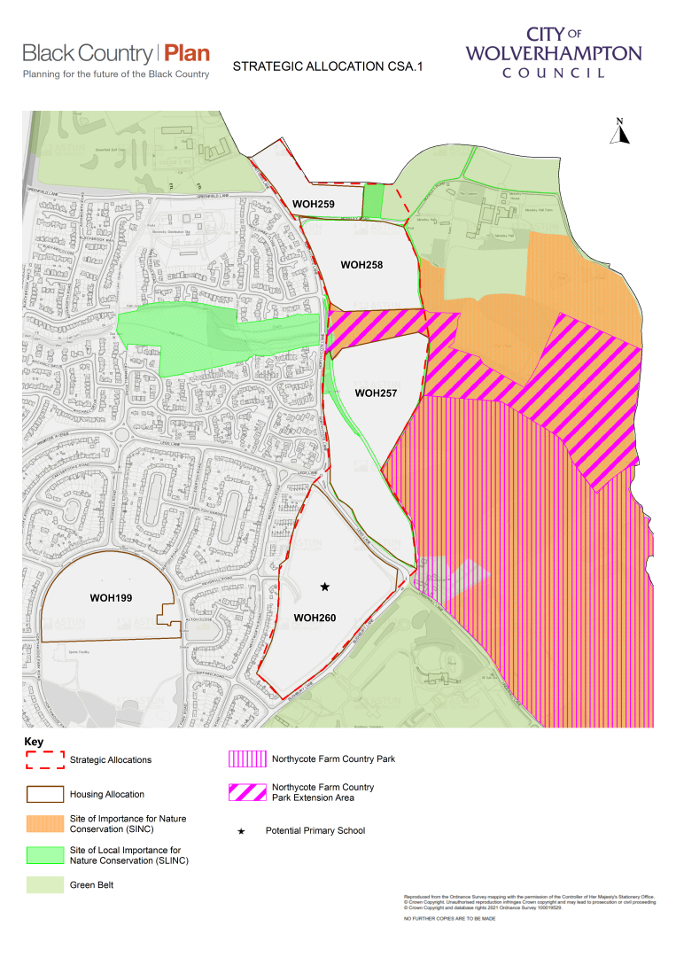
D.30 The Bushbury Strategic Allocation falls within the Bushbury Neighbourhood Growth Area and covers BCP Housing Allocations WOH257, WOH258, WOH259 and WHO260. These sites have been removed from the green belt and allocated to deliver 532 homes in total, at an average net density of 40 dph, together with sufficient space to provide a two-form entry primary school.
The estimated phasing of delivery is:
- By 2029: 348 homes and primary school (if necessary)
- 2029-34: 184 homes
- The sites are currently in two separate ownerships; however, they require an integrated and comprehensive approach to development because they are adjacent to each other and have joint infrastructure needs, in terms of:
- school place impacts;
- highways impacts;
- delivery of mitigation for green belt loss ;
- delivery of biodiversity net gain;
- delivery of improvements to recreational open space
- The potential new primary school could also serve the needs of the Fallings Park Strategic Allocation (see Policy CSA2).
- The key planning requirements for the Bushbury Strategic Allocation are set out below. Other standard policy requirements, as set out in the BCP and Wolverhampton Local Plan documents and SPDs, will also apply. A masterplan will be prepared to guide comprehensive development of the Bushbury Strategic Allocation. This will provide further detail on the requirements set out in this Policy and will provide a spatial framework for developments.
School Place Requirements
D.34 Current pupil yield estimates from housing developments indicate that additional primary school places may be required to serve the Bushbury Neighbourhood Growth Area and other planned housing developments in the north east of Wolverhampton. Therefore, 2.3ha of Site WOH260 has been set aside for a potential primary school. If this site is not ultimately required for provision of a primary school, it will be brought forward for additional housing. In this event, improvements to increase accessibility to nearby primary schools may be required in accordance with Policy HOU2.
D.35 It is currently anticipated that secondary school place requirements arising from housing developments in the north east of Wolverhampton over the plan period will be capable of being accommodated in existing secondary schools and / or the potential provision of a new secondary school within Wolverhampton. Public transport improvements to increase accessibility to secondary schools may be required in accordance with Policy HOU2.
Highways Requirements
D.36 To avoid adverse impacts on the wider road network, improvements to highway junctions along the Northycote Lane / Legs Lane / Bushbury Lane route will be required. Part of Moseley Road will also need to be upgraded to provide access to Sites WOH258 and WOH259, which will need to be brought forward together. Details will be set out in the masterplan.
Green Belt Loss Mitigation Requirements
D.37 The following measures will together form sufficient mitigation for the loss of green belt at Sites WOH257, WOH258, WOH259 and WOH260:
a. accessibility, biodiversity and environmental quality improvements to Northycote Farm Country Park, which falls within the green belt and is owned and managed by City of Wolverhampton Council;
b. accessibility, biodiversity and environmental quality improvements to 10.4ha of land designated as the Northycote Farm Country Park Extension Area, which is currently in the control of the owner of Sites WOH257, WOH258 and WOH259. This area falls within the green belt and is a designated SINC, which is currently not accessible to the public. The area will be subject to sensitive improvements, opened up for public access and maintained in perpetuity as an extension to the existing Northycote Farm Country Park.
D.38 There will be a requirement for all green belt loss mitigation works and any necessary transfer of land ownership to be completed before substantial completion of development at sites WOH257, WOH258, WOH259 and WOH260.
D.39 The green belt boundary has been redrawn around the development sites to exclude them from it. In most cases there is an existing landscaped buffer or road that will provide a defensible new green belt boundary. However, the northern boundary of Site WOH259 abuts agricultural land in South Staffordshire. To provide a defensible new green belt boundary in this location, it is important to ensure that the design of development on the site incorporates a significant landscaped buffer along this northern boundary.
D.40 Developments should be designed to minimise potential harm to the integrity of remaining green belt areas and landscape character, as identified in the Black Country Green Belt Study and Black Country Landscape Sensitivity Assessment.
Nature Conservation and Net Biodiversity Gain Requirements
D.41 All existing SINCs, SLINCs, tree preservation orders, hedgerows, woodland and significant trees, both within and adjoining the development sites, should be retained, protected and incorporated sympathetically into the design of development (see Policy ENV4). Sufficient buffer zones should be provided at the edge of these habitat areas, particularly where there are mature trees and hedgerows, to allow them to thrive following development.
D.42 It is anticipated that biodiversity net gain requirements for the developments will be met through delivery of the green belt loss mitigation requirements set out above, and subject to the minimum 10% requirement identified in the Environment Bill / Act and the requirements of Policy ENV3.
Historic Environment Requirements
D.43 The design of developments should respect the existence of historic environment designations in areas to the north, east and south of the sites, specifically: Moseley Old Hall (National Trust); Northycote Farm Grade II Listed Building; Moseley Mill and Fishponds Area of High Historic Landscape Value; Moseley Court Bushbury Designed Landscape of High Historic Value; Moseley Historic Rural Settlement Area of High Historic Townscape Value and Bushbury Hill Conservation Area.
Recreational Open Space Requirements
D.44 Subject to satisfactory delivery of the green belt loss mitigation requirements set out above, it is judged that the local area will have good access to existing recreational open space, allotments and play and sports facilities that have the capacity to meet the varied needs of residents, in line with adopted open space standards. Therefore, no new on-site open space will be required, beyond that necessary to protect existing nature conservation value and to provide sufficient natural, sustainable drainage systems. However, it will be necessary to provide quality walking and cycle routes within the developments, which provide easy, quick and safe access to nearby open spaces and the countryside, and incorporate existing rights of way, including the existing footpath / cycleway track currently dividing the two parts of Site WOH257.
Sustainable Drainage Requirements
D.45 Naturalised sustainable drainage systems that are sufficient to retain greenfield runoff rates should be provided separately for each site, in accordance with Policy CC5. An allowance for the space necessary to accommodate these systems has been made when defining the indicative net developable area. This allowance may be adjusted when the masterplan is prepared.
Local Wastewater Treatment Capacity
D.46 The Black Country Water Cycle Study concludes that there is limited headroom / capacity at the Coven Heath wastewater treatment works serving the area. Severn Trent have identified this constraint and have indicated that they will be able to deliver the upgrades required to local wastewater treatment capacity in a timely manner to support the delivery of developments within Bushbury Neighbourhood Growth Area, and also other developments in the north of Wolverhampton and parts of South Staffordshire, over the Plan period.
(40) Policy CSA2 – Fallings Park Strategic Allocation
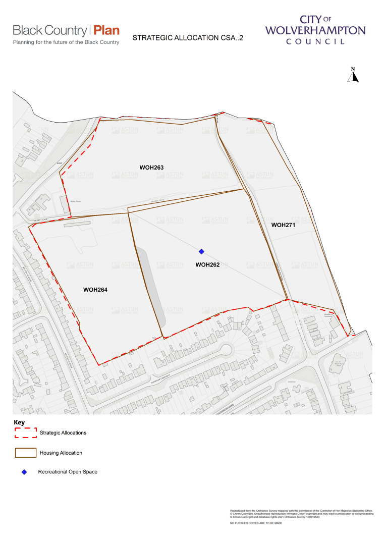
D.47 The Fallings Park Strategic Allocation lies within the Fallings Park Neighbourhood Growth Area and covers BCP Housing Allocations WOH262, WOH263, WOH264 and WOH271. These sites have been removed from the green belt and allocated to deliver 303 homes in total together with a central area of high-quality recreational open space, including play facilities, on Site WOH262, to serve existing and new residents. The sites are suitable for an average density of 40 dph, with the exception of Site WOH271. Due to the linear shape of this site, the rural character of the local area and the need to create a defensible green belt boundary, a development of no more than 25 dph is appropriate.
D.48 The estimated phasing of delivery is:
- By 2029: 200 homes and recreational open space
- 2029-34: 103 homes
D.49 The sites are currently in four separate ownerships; however they require an integrated and comprehensive approach to development because they are adjacent to each other and have joint infrastructure needs, in terms of:
a) school place impacts;
b) highways impacts;
c) delivery of green belt loss mitigation;
d) delivery of biodiversity net gain;
e) delivery of recreational open space
D.50 The potential new primary school on the Bushbury Strategic Allocation could also serve the needs of the Fallings Park Strategic Allocation (see Policy CSA1 above).
D.51 The key planning requirements for the Fallings Park Strategic Allocation are set out below. Other standard policy requirements, as set out in the BCP and Wolverhampton Local Plan documents and SPDs, will also apply. A masterplan will be prepared to guide the comprehensive development of the Fallings Park Strategic Allocation. This will offer further detail on the requirements set out in this Policy and will also provide a spatial framework for developments.
School Place Requirements
D.52 Current pupil yield estimates from housing developments indicate that additional primary school places may be required to serve the Fallings Park Neighbourhood Growth Area and other housing developments over the plan period in the north east of Wolverhampton. Therefore, 2.3ha of Site WOH260 has been set aside for a potential primary school.
D.53 It is currently anticipated that secondary school place requirements arising from housing developments in the north east of Wolverhampton over the plan period will be capable of being accommodated in existing secondary schools and / or the potential provision of a new secondary school within Wolverhampton.
Highways Requirements
D.54 To avoid adverse impacts on the wider road network, major improvements will be required to Grassy Lane, Wood Hayes Road, the Grassy Lane \ Wood Hayes Road junction and the Wood Hayes Road \ Wood End Road signal-controlled junction. Development would also contribute towards increasing congestion on Cannock Road, which has been identified as a pinch point requiring medium term investment.
D.55 Therefore, major improvements along the routes of Cannock Road and Wood Hayes Road are likely to be required. Details will be set out in the masterplan.
Green Belt Loss Mitigation Requirements
D.56 Mitigation for the loss of green belt at Sites WOH262, WOH263, WOH264 and WOH271 will be provided through accessibility, biodiversity and environmental quality improvements to the significant areas of recreational open space located in the nearby Bushbury Hill area, which fall within the green belt and are owned and managed by City of Wolverhampton Council. These cover: Tennyson Road Neighbourhood Park; Bushbury Hill Amenity Area; and Sandy Lane Allotments.
D.57 There will be a requirement for all green belt loss mitigation works and any necessary transfer of land ownership to be completed before substantial completion of development at sites WOH262, WOH263, WOH264 and WOH271.
D.58 The green belt boundary has been redrawn around the development sites to exclude them and to align with the administrative boundary between Wolverhampton and South Staffordshire. To the north and east this lies along a culvert / brook and hedgerows and through agricultural fields. To provide a defensible new green belt boundary in this location, it is important that the design of development incorporates significant landscaped buffers, which will also enhance the nature conservation value of existing habitats.
D.59 Developments should be designed to minimise potential harm to the integrity of remaining green belt areas and landscape character, as identified in the Black Country Green Belt Study and Black Country Landscape Sensitivity Assessment.
Nature Conservation and Net Biodiversity Gain Requirements
D.60 All existing hedgerows, woodland and significant trees both within and adjoining the development sites should be retained, protected and incorporated sympathetically into the design of development (see Policy ENV4). Sufficient buffer areas should be provided at the edge of these habitat areas, particularly where mature trees and hedgerows exist, to allow them to thrive following development.
D.61 It is anticipated that biodiversity net gain requirements for the developments will be met on-site or through the green belt mitigation measures set out above, and subject to the minimum 10% requirement identified in the Environment Bill / Act and the requirements of Policy ENV3.
Recreational Open Space Requirements
D.62 1ha of recreational open space, including play facilities, will be provided on Site WOH262 to deliver a park to serve residents. Following this provision, the local area will benefit from good access to recreational open space, allotments, play and sports facilities that together have the capacity to meet the varied needs of residents, in line with adopted open space standards. No additional new on-site open space is likely to be required, beyond that necessary to protect existing nature conservation value and provide sufficient natural, sustainable drainage systems. However, it will be necessary to provide quality walking and cycle routes within the developments that provide easy, quick and safe access to nearby open spaces and the countryside, and which also incorporate existing rights of way.
Sustainable Drainage Requirements
D.63 Naturalised sustainable drainage systems that are sufficient to retain greenfield runoff rates should be provided in accordance with Policy CC5. Allowances for the space necessary to accommodate these systems, and a culvert standoff zone, have been made when defining the indicative net developable area. These allowances may be adjusted when the masterplan is prepared.
Local Wastewater Treatment Capacity
D.64 The Black Country Water Cycle Study concludes that there is limited headroom / capacity at the Coven Heath wastewater treatment works that serve this area. Severn Trent have identified this constraint and have indicated that they are able to deliver the upgrades required to local wastewater treatment capacity in a timely manner to support the delivery of developments within the Fallings Park Neighbourhood Growth Area, and also other developments in the north of Wolverhampton and parts of South Staffordshire, over the Plan period.
Waste Allocations
Strategic Waste Management Sites
D.65 The existing strategic sites identified on the Waste Key Diagram are the significant waste management facilities operating in the Black Country. They have been identified through a detailed analysis of all known licenced and exempt facilities in each authority's area. Under Policy W2: Waste Sites, the BCA will safeguard existing strategic and other waste management facilities from inappropriate development, to maintain existing levels of waste management capacity. The strategic waste management sites within Wolverhampton are listed in Table 50:
Table 46 - Wolverhampton Strategic Waste Management Sites (BCP Policy W2)
|
BCP Site Ref / Location |
Previous Local Plan Ref (replaced unless stated) |
Site Name and Address |
Operational Capacity (tonnes per annum) |
|
Municipal Waste Recovery - installations |
|||
|
WS03 SRCRA |
SRCAAP – SW1 |
Wolverhampton Energy from Waste (EfW), Crown Street |
115,000 |
|
Municipal Waste Recovery - Supporting Infrastructure |
|||
|
WS13 SRCRA |
SRCAAP – SW2 |
Crown Street Recycling Transfer Station |
20,000 |
|
WS14 BCRA |
BCAAP – BC2 (1) |
Anchor Lane Household Waste Recycling Centre (HWRC) |
10,000 |
|
WS15 SRCRA |
SRCAAP – SW3 |
Shaw Road Household Waste Recycling Centre (HWRC) |
10,000 |
|
Other Significant Waste Management Infrastructure |
|||
|
WS57 BCRA |
Not Allocated |
Ettingshall Inert Waste Recycling Facility, Millfields Road |
100,000 |
|
WS58 BCRA |
Not Allocated |
Neachells Lane WTS (SUEZ Recycling and Recovery UK Ltd) |
25,000 |
|
WS59 BCRA |
Not Allocated |
JMP Wilcox & Company, Road, Beldray Road, Bilston |
45,000 |
|
WS60 BCRA |
BCAAP – BC2 (6) |
Purbrook WTS (S.B. Waste Management & Recycling Ltd), Purbrook Road |
25,000 |
Sources: Environment Agency: Waste Data Interrogator (WDI) 2007 – 2018, Operational Incinerators, 2018, Public Register, Remaining Landfill Capacity in England as at end of 2018 Version 2
Preferred Areas for New Waste Facilities
D.66 A number of employment areas have been identified in the Black Country Waste Study (BCWS) as being suited to the development of new waste recovery, waste treatment and waste transfer infrastructure. Under Policy W3: Preferred Areas for New Waste Facilities, these areas are considered to be the least likely locations to give rise to land use conflicts; in several cases, there is already co-location of existing waste facilities to which new sites would contribute. There are three such areas within Wolverhampton, and these are identified on the Waste Key Diagram and listed in Table 51:
Table 47 - Wolverhampton Preferred Areas for New Waste Facilities (BCP Policy W3)
|
BCP Site Ref / Location |
Site Name and Address |
Potentially suitable waste uses[16] |
Area (hectares) |
|
WPWo1 BCRA |
Wolverhampton / Ettingshall Corridor (North) The area west of the railway line is under pressure from non-employment uses / proximity to housing, however, proposals will be dealt with on a case by case basis. The area to the east of the railway line is less threatened and should therefore be the focus for additional waste uses. |
Energy from Waste Treatment In-vessel composting Anaerobic digestion Transfer Recycling |
88.5 |
|
WPWo2 BCRA |
Wolverhampton / Ettingshall Corridor (South) The area is under pressure from housing proposals with significant areas of interest to the north eastern and western boundaries. The area to the east of the railway line is less threatened, nd should therefore be the focus for additional waste uses. |
Energy from Waste Treatment In-vessel composting Anaerobic digestion Transfer Recycling |
74.5 |
|
WPWo3 BCRA |
Dale Street, Loxdale, Bilston |
Treatment In-vessel composting Anaerobic digestion Transfer Recycling |
20.6 |
Minerals Allocations
D.67 The Black Country Minerals Study (BCMS, Tables 12.10 and 12.9) lists all known existing mineral sites and mineral infrastructure sites in the Black Country. Existing mineral sites within the Black Country include permitted mineral extraction sites, stockpiles, brick and tile works, and a pot clay factory. There are no existing mineral sites in Wolverhampton.
D.68 Existing Black Country mineral infrastructure sites include secondary / recycled aggregates production, rail-linked aggregates depots, coating plants, ready-mix (RMX) concrete batching plants, manufacture of concrete products, and dry silo mortar (DSM) plants.
D.69 Under Policy MIN2: Minerals Safeguarding Areas, the BCA will safeguard all existing mineral sites and mineral infrastructure sites from inappropriate development; this is considered necessary in order to retain existing capacity, thus helping to make the best use of and conserve the Black Country's finite mineral resources.
D.70 The locations of Black Country mineral sites and mineral infrastructure sites are identified on the Minerals Key Diagram, and those sites located within Wolverhampton are listed in Table 52:
Table 48 - Wolverhampton Mineral Infrastructure Sites (BCP Policy MIN2)
|
BCP Site Ref / Location |
Previous Local Plan Ref (replaced unless stated) |
Site Name |
Address |
Type |
|
MIWo1 WCRA |
Not Allocated |
Aggregate Industries (Wolverhampton) |
Manfield Road, Wolverhampton |
Concrete batching plant |
|
MIWo2 BCRA |
Not Allocated |
Britannia Onsite Concrete |
Oxford Street/ Vulcan Road, Bilston |
Concrete batching plant |
|
MIWo3 BCRA |
Not Allocated |
CPI Mortars (Wolverhampton) |
Springvale Industrial Estate, Springvale Avenue, Bilston |
Dry silo mortar plant |
|
MIWo4 WCRA |
Not Allocated |
Dismantling & Engineering Services |
Noose Lane, Willenhall |
Aggregates recycling |
|
MIWo5 BCRA |
BCAAP – BC2 (5) |
Ettingshall Asphalt Plant |
Spring Road, Wolverhampton, |
Coating plant |
|
MIWo6 BCRA |
BCAAP – BC2 (5) |
Ettingshall Recycling Facility |
Millfields Road, Ettingshall |
Aggregates recycling |
|
MIWo7 BCRA |
Not Allocated |
G L Ready Mix Concrete |
Unit 1a, Thomas Street, Blakenhall |
Concrete batching plant |
|
MIWo8 BCRA |
Not Allocated |
Hanson Ready Mix, Concrete (Wolverhampton) |
Neachells Lane, Wednesfield |
Concrete batching plant |
|
MIWo9 WCRA |
Not Allocated |
Landywood Concrete Products Ltd |
Neachells Lane, Wednesfield |
Concrete batching plant |
|
MIWo10 WCRA |
Not Allocated |
Neachells Lane Transfer Station |
Consolidation House, Neachells Lane, Willenhall |
Specialist facility for manufacture of concrete blocks from recovered street sweepings |
|
MIWo11 BCRA |
Not Allocated |
Premier Mortars (Wolverhampton) |
Chillington Works Industrial Estate, Cross Street, Eastfield |
Dry silo mortar plant |
|
MIWo12 BCRA |
Not Allocated |
S S Concrete |
Price Street, Bilston |
Concrete batching plant |
|
MIWo13 BCRA |
BCAAP – BC2 (5) |
Tarmac Concrete Ettingshall |
Millfields Road, Ettingshall |
Concrete batching plant |