- 1 Introduction
- 2 The Black Country 2039: Spatial Vision, Strategic Objectives and Strategic Priorities
- 3 Spatial Strategy
- 4 Infrastructure & Delivery
- 5 Health and Wellbeing
- 6 Housing
- 7 The Black Country Economy
- 8 The Black Country Centres
- 9 Transport
- 10 Environmental Transformation and Climate Change
- 11 Waste
- 12 Minerals
- 1 Sub-Areas and Site Allocations
- 2 Delivery, Monitoring, and Implementation
- 3 Appendix – changes to Local Plans
- 4 Appendix – Centres
- 5 Appendix – Black Country Plan Housing Trajectory
- 6 Appendix – Nature Recovery Network
- 7 Appendix – Glossary (to follow)

Draft Black Country Plan
(34) 10 Environmental Transformation and Climate Change
Introduction
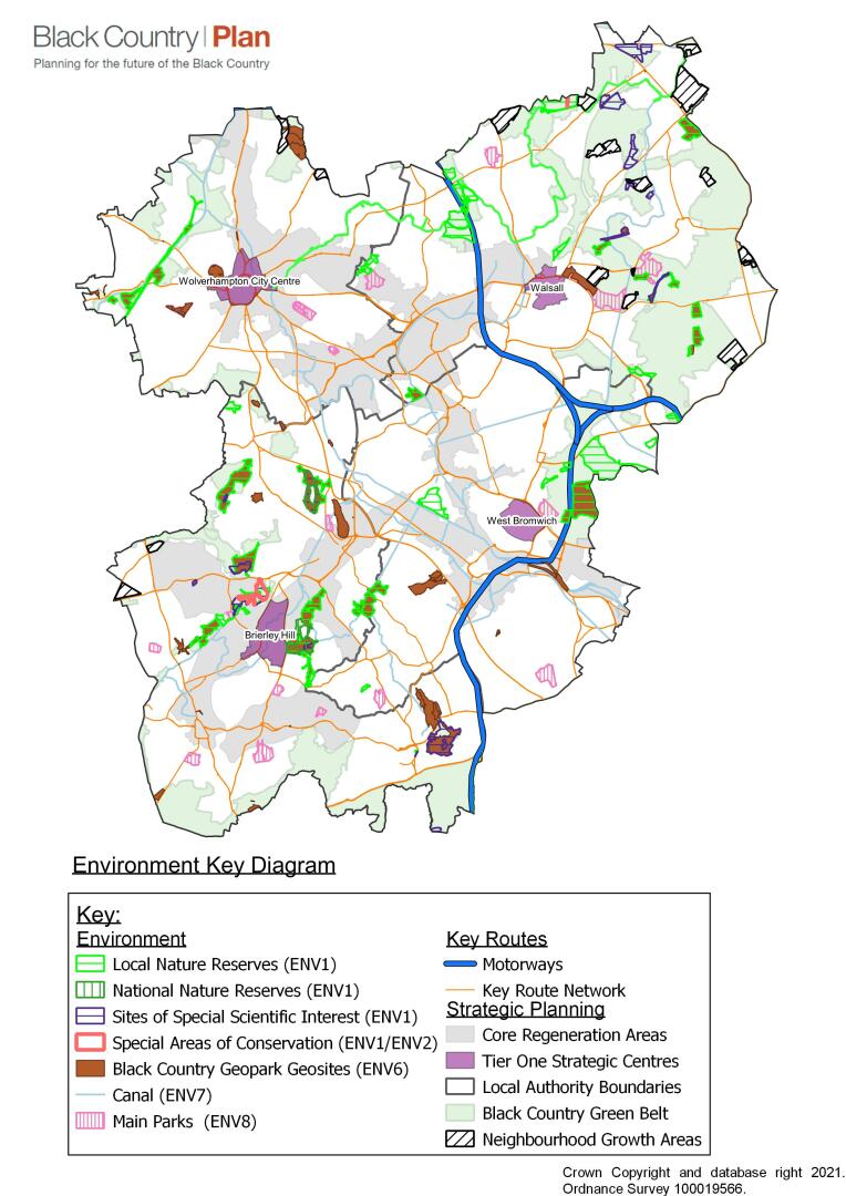
10.1 The Black Country enjoys a unique physical and cultural heritage thanks to its origins as a mainstay of heavy industry and driver of the Industrial Revolution. The geological complexity of the area, its topography, its settlement pattern and the existence of significant areas of green and open space within one of the most densely-developed parts of the country require a set of robust and relevant planning policies that will help to protect and enhance what gives the Black Country its unique physical, ecological and historic character and appearance.
10.2 The protection and improvement of the Black Country's biodiversity and geodiversity will improve the attractiveness of the area for people to live, work, study and visit while at the same time improving the physical and natural sustainability of the conurbation in the face of climate change. This will directly contribute to achieving Spatial Objectives 1, 2, 5, 6, 11 and 12.
10.3 The BCP addresses a number of established and emerging topic areas, including the natural and historic environments, air quality, flooding and climate change.
10.4 The chapter includes a specific section containing policies designed to mitigate and adapt to a changing climate, including policies on the management of heat risk, the use of renewable energy, the availability of local heat networks and the need for increasing resilience and efficiency to help combat the changes that are affecting people and the environment.
10.5 The importance of green infrastructure in achieving a healthy and stable environment is reflected throughout the plan and is supported in this chapter by policies on trees and environmental net gain.
10.6 The importance of the Black Country in terms of its contribution to geological science and the environment is recognised by its UNESCO Geopark status, which is also reflected in a policy for the first time.
10.7 The Black Country contains, or has the potential to impact on, several Special Areas of Conservation (including Cannock Chase). These sites are of European importance and the Black Country has a major role to play in ensuring their special environmental qualities are not impacted adversely by development.
Figure 10 - Environment Key Diagram
Nature Conservation - Spatial Objectives
10.8 The protection and improvement of the Black Country's biodiversity and geodiversity will safeguard and improve the environmental attractiveness and value of the area for residents and visitors while at the same time improving the physical and natural sustainability of communities within the conurbation in the face of climate change. This will directly contribute to delivering Strategic Priority 11, which is also associated with supporting the physical and mental wellbeing of residents.
(59) Policy ENV1 – Nature Conservation
- Development within the Black Country will safeguard nature conservation, inside and outside its boundaries, by ensuring that:
- development will not be permitted where it would, alone or in combination with other plans or projects, have an adverse impact on the integrity of an internationally designated site, including Special Areas of Conservation (SAC), which are covered in more detail in Policy ENV2;
- development is not permitted where it would harm nationally (Sites of Special Scientific Interest and National Nature Reserves) or regionally (Local Nature Reserves and Sites of Importance for Nature Conservation) designated nature conservation sites;
- locally designated nature conservation sites (Sites of Local Importance for Nature Conservation), important habitats and geological features are protected from development proposals that could negatively impact them;
- the movement of wildlife within the Black Country and its adjoining areas, through both linear habitats (e.g. wildlife corridors) and the wider urban matrix (e.g. stepping-stone sites) is not impeded by development;
- species that are legally protected, in decline, are rare within the Black Country or that are covered by national, regional, or local Biodiversity Action Plans will be protected as far as possible when development occurs.
- Adequate information must be submitted with planning applications for proposals that may affect any designated site or important habitat, species, or geological feature, to ensure that the likely impacts of the proposal can be fully assessed. Where the necessary information is not made available, there will be a presumption against granting permission.
- Where, exceptionally, the strategic benefits of a development clearly outweigh the importance of a local nature conservation site, species, habitat or geological feature, damage must be minimised. Any remaining impacts, including any reduction in area, must be fully mitigated. Compensation will only be accepted in exceptional circumstances. A mitigation strategy must accompany relevant planning applications.
- Over the plan period, the BCA will update evidence on designated nature conservation sites and Local Nature Reserves as necessary in conjunction with the Local Sites Partnership and Natural England and will amend existing designations in accordance with this evidence. Consequently, sites may receive new, or increased, protection over the Plan period.
- All appropriate development should positively contribute to the natural environment of the Black Country by:
- extending nature conservation sites;
- improving wildlife movement; and / or
- restoring or creating habitats / geological features that actively contribute to the implementation of Nature Recovery Networks, Biodiversity Action Plans (BAPs) and / or Geodiversity Action Plans (GAPs) at a national, regional, or local level.
- Details of how improvements (appropriate to their location and scale) will contribute to the natural environment, and their ongoing management for the benefit of biodiversity and geodiversity, will be expected to accompany planning applications.
- Local authorities will provide additional guidance on this in Local Development Documents and SPDs where relevant.
(5) Justification
10.9 The past development and redevelopment of the Black Country, along with Birmingham, has led to it being referred to as an "endless village"[24], which describes the interlinked settlements and patches of encapsulated countryside present today. The Black Country is home to internationally and nationally designated nature conservation sites and has the most diverse geology, for its size, of any area on Earth[25]. Many rare and protected species are found thriving within its matrix of greenspace and the built environment.
10.10 The Black Country lies at the heart of the British mainland and therefore can play an important role in helping species migrate and adapt to climate change as their existing habitats are rendered unsuitable. It is therefore very important to increase the ability of landscapes and their ecosystems to adapt in response to changes in the climate by increasing the range, extent, and connectivity of habitats. In order to protect vulnerable species, the Nature Recovery Network process, which is taking place at a national level, will allow isolated nature conservation sites to be protected, buffered, improved, and linked to others. This will be supplemented by the emerging Black Country Nature Recovery Network Strategy, which all development will be required to consider as set out under Policy ENV3. Species dispersal will be aided by extending, widening, and improving the habitats of wildlife corridors. Conversely, fragmentation and weakening of wildlife sites and wildlife corridors by development will be opposed.
10.11 Development offers an opportunity to improve the local environment and this is especially so in an urban area. The BCA are committed to meeting their "Biodiversity Duty" under the Natural Environment and Rural Communities Act (2006) and to delivering the principles of the NPPF by proactively protecting, restoring and creating a richer and more sustainable wildlife and geology.
10.12 The local Biodiversity Partnership, Geodiversity Partnership and Local Sites' Partnership will identify, map, and regularly review the priorities for protection and improvement throughout the Black Country, in accordance with the emerging Black Country Nature Recovery Network strategy. These will be used to inform planning decisions.
(2) Primary Evidence
- Birmingham and Black Country EcoRecord
- Birmingham and Black Country Local Sites Assessment Reports
- Biodiversity Action Plan for Birmingham and the Black Country (2009)
- Geodiversity Action Plan for the Black Country (2005)
- An Ecological Evaluation of the Black Country Green Belt (2019)
(2) Delivery
- Biodiversity and Geodiversity Action Plans.
- Development and implementation of Black Country Nature Recovery Network
- Updated ecological surveys and Local Sites Assessment Reports, as appropriate.
- Preparation of Local Development Documents.
- Development Management process.
Issues and Options consultation response
10.13 Policy ENV1 has worked effectively to protect and enhance biodiversity
10.14 Support from a number of respondents for including ancient woodland in list of nationally designated sites
10.15 The Policy should allow for appropriate mitigation or off-setting so that development sites are not sterilised unduly
10.16 The overall consensus from issues and options was that ENV1 worked well at protecting nature conservation and could be strengthened with the addition of reference to ancient woodlands,
Special Areas of Conservation
10.17 There are a number of Special Areas of Conservation (SAC) within and close to the Black Country which may be adversely affected by development within the Black Country over the Plan period. A policy approach is required to address any identified potential impacts.
(19) Policy ENV2 - Development Affecting Special Areas of Conservation (SACs)
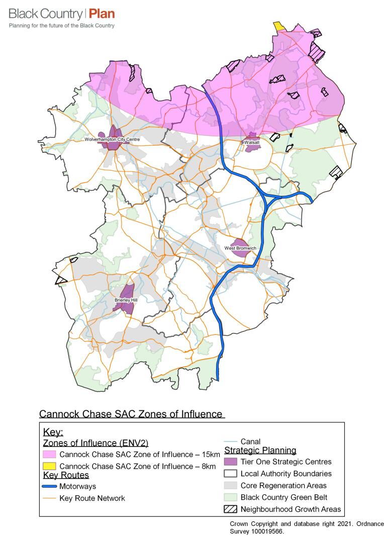
Cannock Chase SAC
- An appropriate assessment will be carried out for any development that leads to a net increase in homes or creates visitor accommodation within 15 km of the boundary of Cannock Chase SAC, as shown on the Policies Maps for Walsall and Wolverhampton.
- If the appropriate assessment determines that the development is likely to have an adverse impact upon the integrity of Cannock Chase SAC, then the developer will be required to demonstrate that sufficient measures can be provided to either avoid or mitigate the impact.
- Acceptable mitigation measures will include proportionate financial contributions towards the current agreed Cannock Chase SAC Partnership Site Access Management and Monitoring Measures (SAMMM).
Figure 11 - Cannock Chase SAC
(2) Justification
10.18 There are a number of Special Areas of Conservation (SAC) within and close to the Black Country. Fens Pool SAC is located in Dudley and the Cannock Extension Canal extends between Walsall and Cannock. Cannock Chase SAC, located to the north of the Black Country, is one of the best areas in the UK for European dry heath land and is the most extensive area of dry heath in the Midlands.
Cannock Chase SAC
10.19 Walsall and Wolverhampton Councils are part of the Cannock Chase SAC Partnership, which works together to prevent damage to the SAC. Other members of the Partnership include Natural England, Staffordshire County Council, Cannock Chase District Council, Lichfield District Council, East Staffordshire Borough Council, South Staffordshire District Council, the Forestry Commission and the Area of Outstanding Natural Beauty (AONB) Partnership. A key role of the Partnership is to ensure no adverse effect on the integrity of the SAC arises from new housing development via recreational pressure.
10.20 A Visitor Survey and Planning Evidence Base Review (PEBR) completed by the Partnership during 2019-21 demonstrated that any development within 15 km of Cannock Chase SAC that could increase visitor use of Cannock Chase may have a significant impact on the integrity of the SAC. The PEBR recommended a package of Site Access Management and Monitoring Measures (SAMMM), which are considered necessary to mitigate the cumulative impact of maximum potential housing development within the 15 km zone up to 2040. These measures include habitat management and creation; access management and visitor infrastructure; publicity, education and awareness raising; provision of additional recreational space within development sites where they can be accommodated; and measures to encourage sustainable travel. Completion of an updated Cannock Chase SAC Partnership Memorandum of Understanding (MOU) to reflect this new evidence is anticipated by 2022.
10.21 Parts of northern Walsall and Wolverhampton, as shown on Figure 11 and the Policies Maps, fall within 15 km of Cannock Chase SAC. Any development within this area over the Plan period that results in new homes or creates visitor accommodation, such as a hotel or caravan site, may lead to adverse effects on the SAC through increased visitor activities. Therefore, Walsall and Wolverhampton Councils will seek contributions towards the total cost of the Cannock Chase SAC SAMMM in proportion to the amount of housing development anticipated to take place within the 15 km zone.
10.22 Given the significantly higher frequency of visits to Cannock Chase SAC from households living within 8 km of the SAC, a higher level of contributions may be sought from housing developments within this zone. Also, given the need to create an effective contributions system that secures a reasonable minimum level of contributions from each development, it is likely that, within the Black Country, only developments of ten homes or more will be expected to make a payment towards the Cannock Chase SAC SAMMM. Guidance will be produced to set out the detailed procedure and the level of financial contributions required. This guidance will come into effect following completion of the MOU.
10.23 Policy ENV2, supported by guidance, will ensure that decisions made on planning applications in the Black Country will not have adverse effects on Cannock Chase SAC. If there are any potential adverse impacts, the development must be refused unless there are appropriate mitigation measures in place. Any proposals that comply with the current guidance are likely to result in a conclusion of no adverse impact on the integrity of Cannock Chase SAC.
Nitrous Oxide (NOx) Deposition
10.24 A number of different types of development can increase the levels of Nitrous Oxide (NOx) deposition that may affect designated SACs, both directly (via increasing industrial emissions) or indirectly (for example, via increasing traffic usage on main roads that run within close proximity of the boundary of the SAC). Where it is possible that a development may result in harm to a SAC by significantly increasing the level of NOx deposition, then the relevant Council will carry out an appropriate assessment and may require the developer to provide sufficient measures to either avoid or mitigate adverse impacts.
10.25 A partnership approach is being developed to address NOx deposition impacts on SACs in the West Midlands area. When the Partnership is established, evidence collected, and a system developed to address NOx deposition avoidance and mitigation, it is anticipated that this will provide an effective mechanism to deal with NOx impacts, similar to that developed for Cannock Chase SAC visitor impacts.
Fens Pools SAC
10.26 The Fens Pools SAC extends to approximately 20 hectares and is located in Dudley. The site comprises three canal feeder reservoirs and a series of smaller pools and a wide range of other habitats from swamp, fen and inundation communities to unimproved neutral and acidic grassland and scrub. Great crested newts (Triturus cristatus) occur as part of an important amphibian assemblage which comprises the qualifying species feature of the SAC.
10.27 Fens Pools SAC is sensitive to changes in air quality and vulnerable to water pollution, as these may affect nutrient neutrality at the site. The Habitats Regulations Assessment Screening of the draft BCP has concluded that further evidence is needed on current air quality and modelling of potential traffic movements close to the site before a conclusion can be drawn on the potential impact of the draft BCP proposals on Fens Pool SAC and any necessary policy response. This evidence will be available to inform the Publication BCP and may require the inclusion of a specific approach in Policy ENV2. Habitat fragmentation has been identified as a threat to the 'great crested newt' qualifying feature of the site.
Cannock Extension Canal SAC
10.28 The Cannock Extension Canal SAC covers an area of approximately 5.47 hectares and is partially situated within north Walsall. It is an example of anthropogenic, lowland habitat that is fed by the Chasewater Reservoir SSSI. Its qualifying feature is floating water-plantain (Luronium natans) and the canal supports the eastern limit of the plant's natural distribution in England. A very large population of the species occurs in the canal, which has a diverse aquatic flora and rich dragonfly fauna, indicative of good water quality.
10.29 Air quality has been identified as a threat to the 'floating water-plantain' qualifying feature of Cannock Extension Canal SAC. Of particular concern is atmospheric nitrogen deposition and ground level ozone. The Habitats Regulations Assessment Screening of the draft BCP has concluded that further evidence is needed regarding air quality and modelling of potential traffic movements close to the site before a conclusion can be drawn on the potential impact of the draft BCP proposals and any necessary policy response. This evidence will be available to inform the Publication BCP.
(1) Evidence
- Cannock Chase SAC Planning Evidence Base Review: Stage 1 (Footprint Ecology, 2018)
- Cannock Chase Visitor Survey (Footprint Ecology, 2018)
- Cannock Chase SAC Planning Evidence Base Review: Stage 2 (Footprint Ecology, 2021)
- Habitats Regulations Assessment Screening of Draft Black Country Plan (Lepus, 2021)
- Draft Black Country Plan Duty to Cooperate Statement (2021)
(1) Delivery
- Completion of Cannock Chase SAC Partnership Memorandum of Understanding
- Preparation of Cannock Chase SAC Mitigation Guidance for Wolverhampton and Walsall
- Completion of air quality and transport modelling evidence for Fens Pool SAC
- Development Management process
Issues and Options Consultation Responses
10.30 Respondents requested that the Plan should make reference to the updated evidence base on Cannock Chase SAC (CCSAC) and include a policy to address CCSAC issues to align with other CCSAC Partnership authorities.
Nature Recovery Network and Biodiversity Net Gain
10.31 The Nature Recovery Network (NRN) is a major commitment in the government's 25 Year Environment Plan. The Government has set out in the Environment Bill 2019 - 21 that a Local Nature Recovery Strategy (LNRS) is to be prepared locally and published for all areas of England, and that these will:
a) agree priorities for nature's recovery;
b) map the most valuable existing habitat for nature using the best available data; and
c) map specific proposals for creating or improving habitat for nature and wider environmental goals.
10.32 LNRS will help restore many ecosystem functions and improve the services upon which society depends, benefitting nature, people and the economy, and helping to address three of the biggest challenges society faces: biodiversity loss, climate change and human wellbeing.
10.33 LNRS will support delivery of mandatory biodiversity net gain and provide a focus for a strengthened duty on all public authorities to conserve and enhance biodiversity, which is also being introduced by the Bill. They will underpin the Nature Recovery Network, alongside work to develop partnerships and to integrate nature into incentives and land management actions.
10.34 Biodiversity net gain is a process that attempts to leave the environment in a more valuable and richer condition than it was found to be in previously. The Government has set out in the Environment Bill 2019 - 21 that development proposals are required to provide a minimum 10% uplift in habitat quality where sites are being developed.
10.35 This process involves the use of a metric as a proxy for recognising the negative impacts on habitats arising from a development and calculating how much new or restored habitat, and of what types, is required to deliver sufficient net gain.
10.36 The Environment Bill 2019 - 21 is scheduled to progress to the draft legislation stage and be laid before Parliament in Autumn 2022. Policy ENV3 sets out how development proposals would be required to consider the Nature Recovery Network Strategy and how biodiversity net gain would be secured
(52) Policy ENV3 – Nature Recovery Network and Biodiversity Net Gain
- All development shall deliver the Local Nature Recovery Network Strategy in line with the following principles:
- take account of where in the Local Nature Recovery Network the development is located and deliver benefits appropriate to that zone;
- follow the mitigation hierarchy of avoidance, mitigation and compensation, and provide for the protection, enhancement, restoration and creation of wildlife habitat and green infrastructure;
- follow the principles of Making Space for Nature and recognise that spaces are needed for nature and that these should be of sufficient size and quality and must be appropriately connected to other areas of green infrastructure, to address the objectives of the Black Country Nature Recovery Network Strategy.
- All development shall deliver a minimum 10% net gain in biodiversity value when measured against baseline site information.
- Losses and gains as a result of proposed development will be calculated using the national Biodiversity Metric.
- Development that is likely to have an impact on biodiversity will be considered in accordance with the mitigation hierarchy set out in the NPPF.
- Biodiversity net gain shall be provided in line with the following principles:
- a preference for on-site habitat provision / enhancement wherever practicable, followed by improvements to sites within the local area, and then other sites elsewhere within the Black Country;
- the maintenance and where possible enhancement of the ability of plants and animals (including pollinating insects) to move, migrate and genetically disperse across the Black Country;
- the provision / enhancement of priority habitats identified at the national, regional, or local level, having regard to the scarcity of that habitat within the Black Country;
- Exemptions to the need to provide biodiversity net gain on all development will be as set out in the relevant legislation and national guidance.
- Compensation will only be accepted in exceptional circumstances. Provision of off-site compensation should not replace or adversely impact on existing alternative / valuable habitats in those locations and should be provided prior to development.
Justification
10.37 Locally developed Nature Recovery Network strategies are due to be introduced through the Environment Bill. LNRS will help to map the NRN locally and nationally, and will help to plan, prioritise and target action and investment in nature at a regional level across England.
10.38 The Environment Bill (when enacted) will introduce a new duty on all public bodies to have regard to any relevant LNRSs, creating an incentive for a wide range of organisations to engage with the creation of LNRSs and to take steps to support their delivery. Local authorities and other public bodies designated by the Secretary of State will also have to report on what steps they have taken, at least every five years.
10.39 The Black Country Authorities have commenced work on a Local Nature Recovery Network Strategy. This has produced draft opportunities mapping that future development proposals will be required to consider in demonstrating how they deliver benefits appropriate to the zones identified. The draft Nature Recovery Network Opportunities Map (April 2021) is shown at Appendix 18 alongside a description of the components of the opportunities map.
10.40 The Environment Bill underpins the government's approach to establishing the NRN. The Environment Bill: sets the framework for at least one legally binding biodiversity target; establishes spatial mapping and planning tools to identify existing and potential habitat for wildlife and agrees local priorities for enhancing biodiversity in every area of England (LNRS); creates duties and incentives, including mandatory biodiversity net gain.
10.41 Biodiversity net gain has been described as a measurable target for development projects where impacts on biodiversity are outweighed by a clear mitigation hierarchy approach to first avoid and then minimise impacts, including through restoration and / or compensation.
10.42 Net gain is an approach to development, and / or land management, which aims to leave the natural environment in a measurably better state than beforehand (DEFRA Biodiversity Metric 2.0 Dec 2019).
10.43 Mandatory biodiversity net gain will provide a financial incentive for development to support the delivery of LNRSs through an uplift in the calculation of biodiversity units created at sites identified by the strategy. LNRSs have also been designed to help local planning authorities deliver existing policy on conserving and enhancing biodiversity and to reflect this in the land use plans for their area.
10.44 The Environment Bill 2019 - 21 proposes that new developments must demonstrate a minimum 10% increase in biodiversity on or near development sites. New development should always seek to enhance rather than reduce levels of biodiversity present on a site. This will require a baseline assessment of what is currently present, and an estimation of how proposed designs will add to that level of biodiversity, supported by evidence that a minimum 10% net gain has been delivered.
10.45 Development generates opportunities to help achieve an overall nature conservation benefit. It will often be possible to secure significant improvements through relatively simple measures, such as the incorporation of green infrastructure and features including bird / bat boxes and bricks that can enable wildlife to disperse throughout the Black Country.
10.46 Biodiversity features of value frequently occur beyond designated sites and should be conserved, enhanced and additional features created as part of development.
10.47 On-site biodiversity improvements will also be vital to enhancing the liveability of urban areas, and improving the connection of people to nature, particularly as development densities increase. Development should also contribute to wildlife and habitat connectivity in the wider area, in line with the Biodiversity Action Plan and the developing Black Country Local Nature Recovery Strategy.
10.48 The ways in which developments secure a net gain in biodiversity value will vary depending on the scale and nature of the site. On some sites, the focus will be on the retention of existing habitats. For others, this may be impracticable, and it may be necessary instead to make significant provision for new habitats either on- or off-site.
10.49 It can be challenging to establish new habitats. It is essential that the most important and irreplaceable habitats in the Black Country are protected, and so mitigation rather than retention will not be appropriate in some circumstances.
Evidence
- The Environment Bill 2019 – 2021
- The Government's 25 Year Environment Plan
- Nature Networks Evidence Handbook - Natural England Research Report NERR081
- Making Space for Nature (Lawton et al. 2010)
- DEFRA Biodiversity Metric 2.0 (Dec 2019)
- Biodiversity Net Gain – Principles and Guidance for UK Construction and Developments – CIEEM
Delivery
- Development Management, legal and funding mechanisms.
(2) Issues and Options Consultation Responses
10.50 This is a new policy produced in response to emerging national legislation and thus was not addressed previously.
Provision, retention and protection of trees, woodlands, and hedgerows
10.51 The BCA will support and protect a sustainable, high-quality tree population and will aim to significantly increase tree cover across the area over the Plan period.
10.52 A main theme of the Government's 25-Year Environment Plan is the need to plant more trees. This is to be achieved not only as part of the creation of extensive new woodlands but also in urban areas; this will be accomplished in part by encouraging businesses to offset their emissions in a cost-effective way through planting trees. The national ambition is to deliver one million new urban trees and a further 11 million new trees across the country.
10.53 It is important to encourage and support the delivery of green infrastructure and ecological networks through urban areas, especially in relation to their role in climate change mitigation and adaptation and to mitigate the health problems associated with air pollution. The provision of new trees and the protection of existing ones throughout the Black Country will be a key component of this approach.
10.54 The aim will be to increase the Black Country's canopy cover to at least 18% over the plan period[26], based on data establishing its current levels of provision[27] and identifying opportunities for doing so derived from the Nature Recovery Network and biodiversity net gain targets.
(46) Policy ENV4 – Provision, retention and protection of trees, woodlands and hedgerows
Retention and protection of trees and woodland
- Development that would result in the loss of or damage to ancient trees, ancient woodland or veteran trees will not be permitted. Development adjacent to ancient woodland will be required to provide an appropriate landscaping buffer, with a minimum depth of 15m and a preferred depth of 50m.
- Provision should also be made for the protection of individual veteran or ancient trees likely to be impacted by development, by providing a buffer around such trees of a minimum of 15 times the diameter of the tree. The buffer zone should be 5m from the edge of the tree’s canopy if that area is larger than 15 times its diameter.
- There will be a presumption against the removal of trees that contribute to public amenity and air quality management unless sound arboricultural reasons support their removal[28]. Where removal is unavoidable, replacement trees should be provided to compensate for their loss, on a minimum basis of three for one.
- The planting of new, predominantly native, trees and woodlands will be sought, in appropriate locations, to increase the extent of canopy cover in the Black Country to around 18% over the period to 2039.
- Tree Preservation Orders will be used to protect individual(s) or groups of trees that contribute to the visual amenity and / or the character of an area and that are under threat of damage or removal.
Habitat Creation
- All available data on extant tree cover and associated habitat[29] will be considered when making decisions on the proposed loss of trees and woodland to accommodate infrastructure and other development proposals. In areas where evidence demonstrates that current levels of tree cover are low, proposals that incorporate additional tree planting, to increase existing levels of habitat and canopy cover, will be considered positively, as part of the wider contribution to biodiversity net gain.
- A majority of native tree species able to withstand climate change should be used in landscaping schemes or as replacement planting, to maximise habitats for local wildlife / species and maintain and increase biodiversity. In circumstances where non-native tree species are also considered to be appropriate, a mix of native and non-native species should be provided, to help maintain a healthy and diverse tree population.
- Opportunities for increasing tree provision through habitat creation and the enhancement of ecological networks, including connecting areas of ancient woodland, will be maximised, in particular by means of the biodiversity net gain and nature recovery network initiatives (see Policy ENV3).
Trees and development
- An arboricultural survey, carried out to an appropriate standard, should be undertaken prior to removal of any vegetation or site groundworks and used to inform a proposal’s layout at the beginning of the detailed design process.
- Development should be designed around the need to incorporate trees already present on site, using sensitive and well-designed site layouts to maximise their retention.
- Existing mature trees[30], trees that are ecologically important, and ancient / veteran trees, must be retained and integrated into the proposed landscaping scheme, recognising the important contribution of trees to the character and amenity[31] of a development site and to local green infrastructure networks.
- In addition to meeting the requirements for replacement trees on sites and biodiversity net gain, new tree planting should be included in all new residential developments and other significant proposals[32], as street trees or as part of landscaping schemes. Development proposals should use large-canopied species where possible, which provide a wider range of health, biodiversity and climate change mitigation and adaptation benefits because of their larger surface area and make a positive contribution to increasing overall canopy cover[33].
- New developments should make a minimum contribution of 20% canopy cover across the development site and a recommended contribution of 30% canopy cover across the development site[34].
- New houses and other buildings must be carefully designed and located to prevent an incompatible degree of shade[35] being cast by both existing and new trees that might result in future pressure for them to be removed.
- The positioning of trees in relation to streets and buildings should not worsen air quality for people using and living in them. Care should be taken to position trees and / or design streets and buildings in a way that allows for street-level ventilation to occur, to avoid trapping pollution between ground level and tree canopies (see Policy CC4).
- Where planning permission has been granted that involves the removal of trees, agreed replacement trees of a suitable species must be provided onsite. Where sufficient and suitable onsite replacements cannot be provided, off-site planting or woodland enhancement, including support for natural regeneration, in the near vicinity of the removed tree(s) must be provided, in line with the mitigation hierarchy set out in Policy ENV3. Appropriate planning conditions will be used to secure timely and adequate alternative provision and ongoing maintenance.
- Replacement trees located off-site should not be planted where they would impact on areas designated as ecologically important unless this has been specifically agreed with the relevant authority and its ecological officers / advisers.
- Trees proposed for removal during development should be replaced at a ratio of at least three for one. The species, size and number of replacement trees will be commensurate with the size, stature, rarity, and public amenity of the tree(s) to be removed. Where trees to be replaced form a group of amenity value (rather than individual specimens), replacement must also be in the form of a group commensurate with the area covered, size and species of trees and established quality of the original group and, where possible, located in a position that will mitigate the loss of visual amenity associated with the original group[36].
- Trees on development sites must be physically protected during development. Care must be taken to ensure that site engineering / infrastructure works[37], the storage of plant and machinery, excavations and new foundations do not adversely impact their continued retention, in line with current arboricultural and Building Regulation requirements.
- New trees on development sites should be planted in accordance with arboricultural best practice, including the use of suitably sized planting pits[38], supporting stakes, root barriers, underground guying, and appropriate protective fencing during the construction phase.
- Appropriate conditions will be included in planning permissions to ensure that new trees that fail on development sites are replaced within a specified period by trees of a suitable size, species, and quality.
- Where proposed development will impact on the protection, safety and / or retention of a number of trees, or on the character and appearance of trees of importance to the environment and landscape, the use of an arboricultural clerk of works[39] will be required, to be made subject to a condition on the relevant planning permission.
- A presumption should be applied that replacement trees are UK and Ireland sourced and grown, to help limit the spread of tree pests and diseases, while supporting regional nurseries where possible when acquiring them. Hedgerows
- There will be a presumption against the wholesale removal of hedgerows for development purposes, especially where ecological surveys have identified them to be species-rich and where they exist on previously undeveloped land.
- Hedgerow retention and reinforcement will be of particular importance where hedgerows form part of an established ecological network enabling the passage of flora and fauna into and out of rural, suburban, and urban areas. If hedgerow removal is needed to accommodate a high-quality site layout, replacement hedgerow planting will be required.
- Protection of hedgerows before and during development must be undertaken. This will include: the provision of landscape buffers where appropriate; protective fencing; and careful management of plant and materials on site to avoid damage to the hedgerow(s) and its root system.
- New hedgerows will be sought as part of site layouts and landscaping schemes.
(3) Justification
10.55 Section 15 of the NPPF (2019) identifies the importance of trees in helping to create an attractive and healthy environment. The NPPF expects local plans to identify, map and safeguard components of ecological networks and promote their conservation, restoration, and enhancement. Ancient woodlands and ancient and veteran trees are an irreplaceable aspect of both the ecological and historic landscape and the NPPF is very clear about the need to protect such resources where they occur. Hedgerows are also a finite and vulnerable resource and their provision, retention and enhancement will be expected when new development is proposed.
10.56 Tree canopy cover across the Black Country is currently 13.6%, using information from local and national sources that is regularly updated. The % canopy cover is available at a ward level[40], and varies across the Black Country. There is a need to increase total tree canopy cover to 18%, to help prevent the further fragmentation of habitats across the Black Country, support the Nature Recovery Network, and provide more equal canopy cover across all wards.
10.57 Wildlife corridors are important in helping overcome habitat fragmentation, by ensuring that species can reach the resources they need and that their populations do not become isolated, inbred, and prone to the adverse impacts of climate change. Supporting wildlife corridors will mean:
a) creating and maintaining a diverse tree population (including trees of all ages and sizes),
b) controlling invasive species,
c) promoting the reintroduction of native species in locations where they are appropriate and would have a positive impact on biodiversity,
d) retaining dead wood,
e) making sure that any new planting is in the right location and of the right species, and
f) recognising that woodlands are not simple monoculture habitats and will also contain glades, wet areas, understoreys, and grassland.
10.58 The requirement to plant trees on development sites will also help support and deliver increased biodiversity and green network opportunities on sites that at present do not contain tree cover, e.g. some sites currently in managed agricultural use where trees and hedgerows have previously been removed.
10.59 An example of the importance of trees in helping to manage and mitigate adverse impacts relating to air quality and climate change can be found in the report produced for the London iTree[41] project in 2015 (highlighting the value of London's tree population). This identified that the tree population of inner and outer London (8.5 million trees) held nearly 2.4 million tonnes of carbon and was sequestering an additional 77,000 tonnes per annum, equivalent to the total amount of carbon generated by 26 billion vehicle miles. The project also reported significant value and benefits provided by trees in terms of pollution removal, storm water alleviation, building energy savings and amenity.
10.60 The loss of trees from urban environments has been demonstrated to have negative outcomes for human health. Social costs, such as an increase in crime, have also been associated with the loss of trees[42]. There is a growing body of evidence that the presence of trees in and around urban environments provides major public health and societal benefits.
10.61 Trees in the urban landscape have a vital role to play in delivering ecosystem services[43], such as in:
a) helping to improve residents' physical health[44]
b) helping to improve residents' mental health by reducing stress levels
c) helping to mitigate climate change by sequestering carbon dioxide
d) providing shading and cooling benefits (including associated savings to the NHS from avoided skin cancer and heat stroke[45])
e) improving air quality and reducing atmospheric pollution
f) reducing wind speeds in winter, thereby reducing heat loss from buildings
g) reducing noise
h) Improving local environments and bringing people closer to nature
i) supporting ecological networks and green infrastructure
j) maximising people's enjoyment of and benefits from their environment
k) contributing towards the aesthetic value of the urban area
Trees on development sites
10.62 The BCP is delivering a significant quantum of new development and redevelopment in both urban and semi-rural areas and it will be important to ensure that the existing stock of trees and woodlands is protected, maintained, and expanded as far as possible. Developers will be expected to give priority to the retention of trees and hedgerows on development sites, and existing landscaping should also be kept and protected where possible.
10.63 There will be a requirement to: -
a) replace trees and woodlands that cannot be retained on development sites with a variety of suitable tree specimens (species and size);
b) require developers to both retain trees on sites as part of comprehensive landscape schemes and to provide suitable new trees in locations that will enhance the visual amenity of a development;
c) where individual or groups of trees are of landscape or amenity value, they are retained and that developments are designed to fit around them;
d) encourage diversity in the tree population to help to counter ecological causes of tree loss, such as diseases, pests, or climate change; and
e) balance the impacts of the loss of trees on climate change and flooding by identifying opportunities to plant replacements via appropriate tree and habitat enhancement and creation schemes.
10.64 As part of the requirement for biodiversity net gains (see Policy ENV3) developers and others will need to pursue adequate replacements for trees and woodlands lost to allocated and approved development, as well as additional trees and other habitat creation to achieve appropriate compensatory provision on sites. The main imperative will be to ensure that trees are maintained in good health on development sites in the first instance but where this is not possible, the grant of planning permission will be conditional upon the replacement and enhancement of tree cover nearby.
10.65 Tree species specified in submitted planting plans should be evaluated by either a chartered Landscape Architect or accredited arboriculturist employed by the local authority. This will ensure that a suitable variety of species and standard / size of tree is being planted and will deliver the most appropriate solution for a specific location.
10.66 Normally, for every tree removed from a development site a minimum of three replacement trees will be required to be planted on the site. There will be circumstances where the ratio of replacement planting will be greater than this – especially in cases where significant / mature trees contributing to the visual and ecological amenity of an area and its character are to be removed. Where a development site cannot accommodate additional planting, replacement trees will be expected to be planted in an appropriate off-site location.
10.67 The clearance of trees from a site prior to the submission of a planning application is discouraged. If the Local Planning Authority have robust evidence to prove that trees were until recently present on a cleared site, there will still be a requirement to provide suitable and sufficient replacement trees, either within the proposed scheme or on an alternative identified site. This is also addressed in the amended Environment Bill 2019 - 2021, which makes provision for sanctions against the clearance of sites prior to a planning application being submitted in relation to the requirement for biodiversity net gain.
10.68 To ensure that good tree protection measures are maintained through the construction project, the BCA will support and encourage the use of arboriculture clerks of work on development sites where trees are to be managed, removed and / or planted on the site. Where the likelihood of trees being adversely affected by construction activity is significant, the BCA will use appropriate conditions to require this level of oversight.
Ancient woodland and veteran trees[46]
10.69 The NPPF defines ancient woodland and veteran trees as an irreplaceable habitat. Ancient woodland is an area that has been wooded continuously since at least 1600 AD. It includes ancient semi-natural woodland and plantations on ancient woodland sites. An ancient or veteran tree is a tree which, because of its age, size, and condition, is of exceptional biodiversity, cultural or heritage value. Veteran trees are of exceptional value culturally, in the landscape, or for wildlife, due to their great age, size or location. The soils in which these trees sit has been identified as having a high biodiversity value, given the length of time the trees have been successfully established.
10.70 Individual trees can have historic and cultural value and can be linked to specific historic events or people, or they may simply have importance because of their appearance, contribution to landscape character and local landmark status. Some heritage trees may also have great botanical interest, for example as rare native trees or cultivars of historic interest.
10.71 Very few trees of any species can be classed as ancient or veteran. Such trees / areas are a finite resource of great biodiversity value. For this reason, the BCA consider that it is essential to provide absolute protection for ancient and veteran trees and ancient woodland sites in the Black Country.
Hedgerows
10.72 The planting of hedgerows not only enhances opportunities for wildlife but can also significantly improve the appearance of new development. It is particularly suitable on frontages and along plot and site boundaries, both softening the appearance of the built form and supplementing the design of the overall scheme.
10.73 Hedgerows are integral to ecological networks, given their linear form, and will be essential elements of habitat linkages within and beyond the Black Country. Planting additional hedgerows will help to support and increase the movement of wildlife and plants through the Black Country. The planting of bare root plants is an economical way of providing green infrastructure on sites.
(2) Evidence
- Valuing London's Urban Forest - Results of The London I-Tree Eco Project 2015
- Neighbourhood Greenspace and Health in A Large Urban Center. Sci. Rep. 5, 11610; Doi: 10.1038/Srep11610 (2015)
- Health Benefits of Street Trees - Vadims Sarajevs, The Research Agency Of The Forestry Commission, 2011
- GB Wards Canopy Cover Map
- GB 25-Year Environment Plan
- The Environment Bill 2019 - 2021
Delivery
- Development Management, legal and funding mechanisms.
Issues and Options Consultation Responses
10.74 This is a new policy produced in response to emerging national legislation and thus was not addressed previously.
Historic Character and Local Distinctiveness of the Black Country
10.75 Environmental transformation and promoting sustainable development are two of the underpinning themes of the Black Country Plan Vision, which in turn requires a co-ordinated approach to the conservation and enhancement of the built and natural environment. The protection and promotion of the historic character and local distinctiveness of the Black Country's buildings, settlements and landscapes are key elements of sustainability and transformation and in particular help to deliver Strategic Priority 12, to protect, sustain and enhance the quality of the built and historic environment, whilst ensuring the delivery of distinctive and attractive places.
10.76 Local distinctiveness arises from the cumulative contribution made by many and varied features and factors, both special and commonplace. It is the ordinary and commonplace features of the Black Country that, in fact, give it its distinctiveness and help to create a unique sense of place. This is beneficial for community identity and wellbeing as well as making places attractive to investment.
10.77 The Black Country Historic Landscape Characterisation (2009), along with other urban historic landscape characterisation studies, has provided a key evidence base to inform an understanding of the historic character of the Black Country. This work has been built upon with the preparation of the Black Country Historic Landscape Characterisation Study (2019), and this evidence should be used in considering how new development proposals and the enhancement of existing townscapes and landscape should respect the local character and distinctiveness of the Black Country.
10.78 Policy ENV5 aims to ensure that where physical evidence of local character persists, it should be conserved. Where development is proposed, every effort should be made to ensure that the Black Country's historic environment is fully appreciated and enhanced in terms of its townscape, landscape and individual heritage assets, and that new development makes a positive contribution to the local character and distinctiveness of the Black Country.
(38) Policy ENV 5 - Historic Character and Local Distinctiveness of the Black Country
- All development proposals within the Black Country should sustain and enhance the locally distinctive character of the area in which they are to be sited, whether formally recognised as a designated or non-designated heritage asset. They should respect and respond to its positive attributes in order to help maintain the Black Country’s cultural identity and strong sense of place.
- Development proposals will be required to preserve and enhance local character and those aspects of the historic environment - together with their settings - that are recognised as being of special historic, archaeological, architectural, landscape or townscape quality.
- Physical assets, whether man-made or natural that contribute positively to the local character and distinctiveness of the Black County’s landscape and townscape should be retained and, wherever possible, enhanced and their settings respected.
- The specific pattern of settlements (urban grain), local vernacular and other precedents that contribute to local character and distinctiveness should be used to inform the form, scale, appearance, details, and materials of new development.
- New development in the Black Country should be designed to make a positive contribution to local character and distinctiveness and demonstrate the steps that have been taken to achieve a locally responsive design. Proposals should therefore demonstrate that:
- all aspects of the historic character and distinctiveness of the locality, including any contribution made by their setting, and (where applicable) views into, from, or within them, have been fully assessed and used to inform proposals; and
- they have been prepared with full reference to the Black Country Historic Landscape Characterisation Study (BCHLCS) (October 2019), the Historic Environment Record (HER), and to other relevant historic landscape characterisation documents, supplementary planning documents (SPD’s) and national and local design guides where applicable.
- All proposals should aim to sustain and reinforce special character and conserve the historic aspects of locally distinctive areas of the Black Country, for example:
- The network of now coalesced but nevertheless distinct small industrial settlements of the former South Staffordshire Coalfield, such as Darlaston and Netherton;
- The civic, religious, and commercial cores of the principal settlements of medieval origin such as Wolverhampton, Dudley, Wednesbury and Walsall;
- Surviving pre-industrial settlement centres of medieval origin such as Halesowen, Tettenhall, Aldridge, Oldbury and Kingswinford;
- Rural landscapes and settlements including villages / hamlets of medieval origin, relic medieval and post-medieval landscape features (hedgerows, holloways, banks, ditches, field systems, ridge and furrow), post-medieval farmsteads and associated outbuildings, medieval and early post-medieval industry (mills etc.) and medieval and post-medieval woodland (see Policy ENV4). The undeveloped nature of these areas means there is also the potential for evidence of much earlier activity that has largely been lost in the urban areas;
- Areas of Victorian and Edwardian higher-density development, which survive with a high degree of integrity including terraced housing and its associated amenities;
- Areas of extensive lower density suburban development of the mid-20th century including public housing and private developments of semi-detached and detached housing;
- Public open spaces, including Victorian and Edwardian municipal parks, often created from earlier large rural estates or upon land retaining elements of relict industrial landscape features;
- The canal network and its associated infrastructure, surviving canal-side pre-1939 buildings and structures together with archaeological evidence of the development of canal-side industries and former canal routes (see Policy ENV7);
- Buildings, structures and archaeological remains of the traditional manufacturing and extractive industries of the Black Country including glass making, metal trades (such as lock making), manufacture of leather goods, brick-making, coal mining and limestone quarrying;
- Geosites of geological, historic, cultural, and archaeological significance within the UNESCO Black Country Geopark (see Policy ENV6);
- The Beacons and other largely undeveloped high prominences lying along the Sedgley to Northfield Ridge (including Sedgley Beacon and Wrens Nest), Castle Hill and the Rowley Hills (Turners Hill), and the Queslett to Shire Oak Ridge (including Barr Beacon) and views to and from these locations.
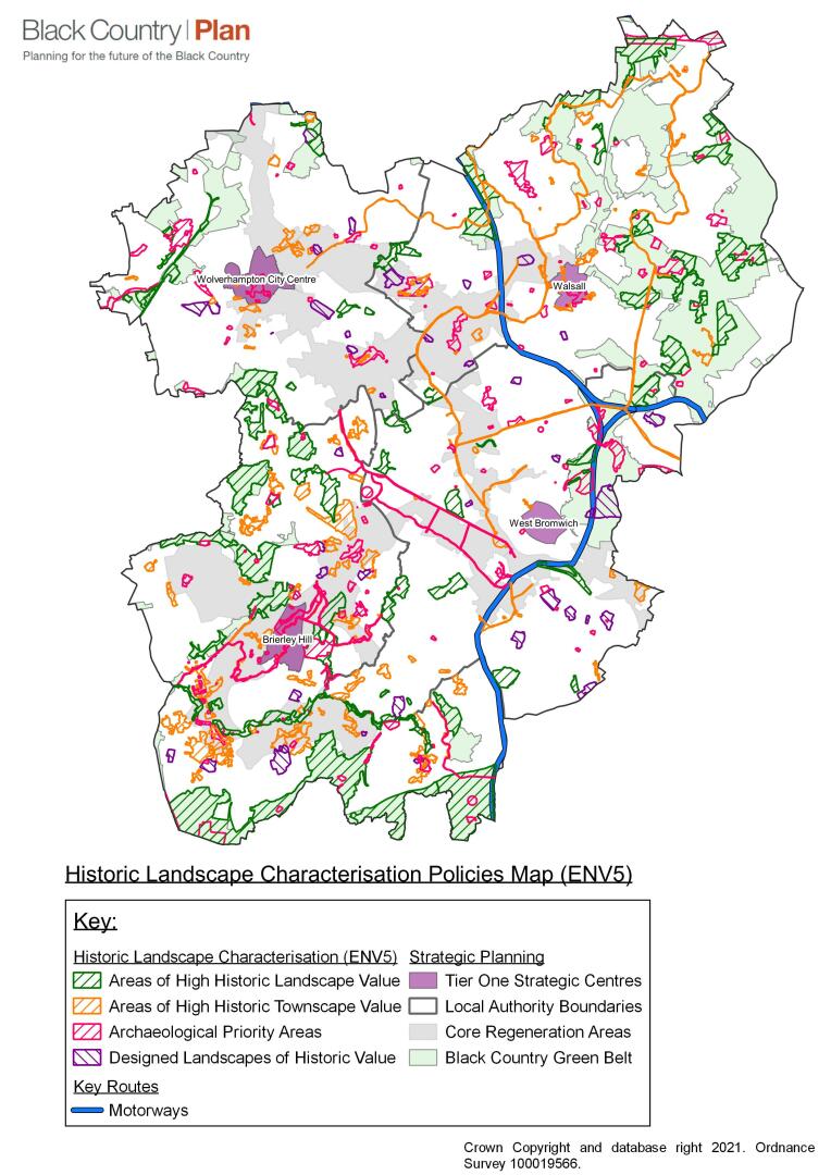
- In addition to designated heritage assets[47], attention should be paid to the following non-designated heritage assets[48] including the Historic Environment Area Designations (HEADS) described and mapped in the Black Country Historic Landscape Characterisation Study (BCHLCS, 2019 – see evidence section for link):
- Areas of High Historic Townscape Value (AHHTV) that exhibit a concentration of built heritage assets and other historic features that, in combination, make a particularly positive contribution to local character and distinctiveness;
- Areas of High Historic Landscape Value (AHHLV) that demonstrate concentrations of important wider landscape elements of the historic environment, such as areas of open space, woodland, watercourses, hedgerows, and archaeological features, that contribute to local character and distinctiveness;
- Designed Landscapes of High Historic Value (DLHHV) that make an important contribution to local historic character but do not meet the criteria for inclusion on the national Register for Parks and Gardens;
- Archaeology Priority Areas (APA) that have a high potential for the survival of archaeological remains of regional or national importance that have not been considered for designation as scheduled monuments, or where there is insufficient data available about the state of preservation of any remains to justify a designation;
- Locally listed buildings / structures and archaeological sites;
- Non-designated heritage assets of archaeological interest;
- Any other buildings, monuments, sites, places, areas of landscapes identified as having a degree of significance[49].
- Development proposals that would potentially have an impact on the significance of any of the above distinctive elements, including any contribution made by their setting, should be supported by evidence that the historic character and distinctiveness of the locality has been fully assessed and used to inform proposals. Clear and convincing justification should be provided, either in Design and Access Statements, Statements of Heritage Significance, or other appropriate reports.
- In some instances, local planning authorities will require developers to provide detailed Heritage Statements and / or Archaeological Desk-based Assessments to support their proposals.
- For sites with archaeological potential, local authorities may also require developers to undertake Field Evaluation to support proposals.
Figure 12 - Historic Landscape Characterisation Policies Map[50]
(2) Justification
10.79 The Black Country has a rich and diverse historic environment, which is evident in the survival of individual heritage assets and in the local character and distinctiveness of the broader landscape. The geodiversity of the Black Country underpins much of the subsequent development of the area, the importance of which is acknowledged by the inclusion of the Black Country Geopark in the UNESCO Global Geopark Network[51]. The exploitation of abundant natural mineral resources, particularly those of the South Staffordshire coalfield, together with the early development of the canal network, gave rise to rapid industrialisation and the distinctive settlement patterns that characterise the area.
10.80 Towns and villages with medieval origins survive throughout the area and remain distinct in character from the later 19th century industrial settlements, which typify the coalfield and gave rise to the description of the area as an "endless village" of communities, each boasting a particular manufacturing skill for which many were internationally renowned.
10.81 Beyond its industrial heartland, the character of the Black Country can be quite different and varied. The green borderland, most prominent in parts of Dudley, Walsall, and the Sandwell Valley, is a largely rural landscape containing fragile remnants of the ancient past. Undeveloped ridges of high ground punctuate the urban landscape providing important views and points of reference that define the character of the many communities. Other parts of the Black Country are characterised by attractive, well-tree'd suburbs with large houses in substantial gardens and extensive mid-20th century housing estates designed on garden city principles.
10.82 This diverse character is under constant threat of erosion from modern development, some small scale and incremental and some large scale and fundamental. As a result, some of the distinctiveness of the more historic settlements has already been lost to development of a "homogenising" character. In many ways the Black Country is characterised by its ability to embrace change, but future changes will be greater and more intense than any sustained in the past. Whilst a legislative framework supported by national guidance exists to provide for the protection of statutorily designated heritage assets the key challenge for the future is to manage change in a way that realizes the regeneration potential of the proud local heritage and distinctive character of the Black Country.
10.83 To ensure that heritage assets make a positive contribution towards the wider economic, social and environmental regeneration of the Black Country, it is important that they are not considered in isolation but are conserved and enhanced within their wider context. A holistic approach to the built and natural environment maximises opportunities to improve the overall image and quality of life in the Black Country by ensuring that historic context informs planning decisions and provides opportunities to link with other environmental infrastructure initiatives.
10.84 An analysis and understanding of the local character and distinctiveness of the area has been made using historic landscape characterization (HLC) principles. Locally distinctive areas of the Black Country have been defined and categorised as Areas of High Historic Townscape Value, Areas of High Historic Landscape Value, Designed Landscapes of High Historic Value, and Archaeology Priority Areas (BCHLCS, 2019). This builds on the work of the original Black Country Historic Landscape Characterization (2009), other local HLC studies and plans, and the Historic Environment Records.
(1) Evidence
- Black Country Historic Landscape Characterisation Study (2019) – available online at: https://blackcountryplan.dudley.gov.uk/t2/p4/t2p4h/ Black Country HLC Final Report 30-10-2019-LR
- Historic Environment Record (HER)
- https://www.gov.uk/government/publications/national-design-guide .
(2) Delivery
- Historic Landscape Characterisation documents prepared by individual local authorities in support of their Local Plan
- Adopted Conservation Area Character Appraisals
- Development Management process including Design and Access Statements and Statements of Heritage Significance
- Supplementary Planning Documents
- A regularly updated and maintained Historic Environment Record (HER).
Issues and Options consultation responses
10.85 Among the issues raised during the consultation, the idea of a heritage policy was broadly supported. The importance of Heritage Statements, and non-designated heritage assets was noted. Greater recognition of nature and natural features in terms of local distinctiveness and historic character was sought, and concerns were expressed about impacts on the Green Belt.
Geodiversity and the Black Country UNESCO Global Geopark
10.86 The geology of the Black Country is very rich in industrial minerals. Limestone, ironstone, fireclay, coal and other industrial minerals provided the ingredients to make iron and paved the way for an intense and very early part of the Industrial Revolution to begin in the area.
10.87 The Black Country UNESCO Global Geopark was declared on Friday 10 July 2020. The Executive Board of UNESCO confirmed that the Black Country had been welcomed into the network of Global Geoparks as a place with internationally important geology, because of its cultural heritage and the extensive partnerships committed to conserving, managing and promoting it.
10.88 A UNESCO Global Geopark uses its geological heritage, in connection with all other aspects of the area's natural and cultural heritage, to enhance awareness and understanding of key issues facing society in the context of the dynamics of modern society, mitigating the effects of climate change and reducing the impact of natural disasters. By raising awareness of the importance of the area's geological heritage in history and society today, UNESCO Global Geoparks give local people a sense of pride in their region and strengthen their identification with the area. The creation of innovative local enterprises, new jobs and high-quality training courses is stimulated as new sources of revenue are generated through sustainable geotourism, while the geological resources of the area are protected.
(7) Policy ENV6 - Geodiversity and the Black Country UNESCO Global Geopark
- Development proposals should:
- wherever possible, make a positive contribution to the protection and enhancement of geodiversity, particularly within the boundaries of the Black Country UNESCO Global Geopark and in relation to the geosites identified within it;
- be resisted where they would have significant adverse impact on the Geopark geosites or other sites with existing or proposed European or national designations in accordance with Government guidance;
- give locally significant geological sites[52] a level of protection commensurate with their importance;
- take into account, and avoid any disruption to, the importance of the inter-connectivity of greenspace and public access between geosites within the boundary of the Black Country UNESCO Global Geopark.
- In their local plans, the BCA should:
- establish clear goals for the management of identified sites (both individually and as part of a network) to promote public access to, appreciation and interpretation of geodiversity;
- ensure geological sites of international, national or regional importance are clearly identified.
(1) Justification
10.89 Paragraph 170 of the NPPF (June 2019) requires local authorities to protect sites of geological value, "… in a manner commensurate with their statutory status or identified quality in the development plan". The Overarching National Policy Statement for Energy[53] states that development should aim to avoid significant harm to geological conservation interests and identify mitigation where possible; effects on sites of geological interest should be clearly identified.
10.90 Areas of geological interest also form significant facets of the industrial landscapes of the Black Country. They reflect the area's history of mining and extraction and will often co-exist with, and form part of the setting of, protected / sensitive historic landscapes. In many cases they also form an intrinsic part of the green infrastructure network, contributing to landscape and ecological diversity as part of the wider natural environment.
10.91 As part of this strategic network of green infrastructure, geosites should be retained wherever possible and their contribution to GI recognised and taken into account when development is proposed that would affect the areas they form part of.
10.92 New development should have regard to the conservation of geological features and should take opportunities to achieve gains for conservation through the form and design of development.
10.93 Where development is proposed that would affect an identified geological site the approach should be to avoid adverse impact to the existing geological interest. If this is not possible, the design should seek to retain as much as possible of the geological Interest and enhance this where achievable, for example by incorporating permanent sections within the design, or creating new interest of at least equivalent value by improving access to the interest.
10.94 The negative impacts of development should be minimised, and any residual impacts mitigated.
UNESCO Global Geoparks
10.95 A UNESCO Global Geopark[54] is a single, unified geographical area where sites and landscapes of international geological significance are located. It is an area of geological significance, managed with three main objectives in mind:
a) to protect the geological landscape and the nature within it;
b) to educate visitors and local communities; and
c) to promote sustainable development, including sustainable tourism.
10.96 All the UNESCO Global Geoparks contain internationally significant geology and are managed through community-led partnerships that promote an appreciation of natural and cultural heritage while supporting the sustainable economic development of the area.
10.97 UNESCO Global Geopark status is not itself a statutory designation.
Evidence
Delivery
- Geopark Management Team, delivering aims of the Geopark
Issues and Options Consultation Responses
10.98 This is a new policy produced in response to the Black Country Geopark being declared by UNESCO in July 202 and was not subject to consultation during issues and options.
Canals of the Black Country
10.99 The Black Country's canal network is one of its most defining historical and environmental assets and its preservation and enhancement remains a major objective in the Vision for environmental transformation across the area and in the delivery of Strategic Priorities 11 and 12. Canals play a multifunctional role, providing economic, social, environmental and infrastructure benefits. They form a valuable part of the green infrastructure and historic environment of the Black Country and have a significant role to play in mental wellbeing and physical health, allowing people opportunities for exercise and access to nature.
(23) Policy ENV7 - Canals
- The Black Country canal network comprises the canals and their surrounding landscape corridors, designated and undesignated historic assets, character, settings, views and interrelationships. The canal network provides a focus for future development through its ability to deliver a high-quality environment and enhanced accessibility for pedestrians, cyclists, and other non-car-based modes of transport.
- All development proposals likely to affect the canal network must:
- safeguard the continued operation of a navigable and functional waterway;
- ensure that any proposals for reinstatement or reuse would not adversely impact on locations of significant environmental value where canals are not currently navigable;
- protect and enhance its special historic, architectural, archaeological, and cultural significance, including the potential to record, preserve and restore such features;
- protect and enhance its nature conservation value including habitat creation and restoration along the waterway and its surrounding environs;
- protect and enhance its visual amenity, key views and setting;
- protect and enhance water quality in the canal.
- reinstate and / or upgrade towpaths and link them into high quality wider pedestrian and cycle networks, particularly where they can provide links to transport hubs, centres and opportunities for employment.
- Where opportunities exist, all development proposals within the canal network must:
- enhance and promote its role in providing opportunities for leisure, recreation and tourism activities;
- enhance and promote opportunities for off-road walking, cycling, and boating access, including for small-scale commercial freight activities;
- preserve and enhance the historical, geological, and ecological value of the canal network and its associated infrastructure;
- positively relate to the opportunity presented by the waterway by promoting high quality design, including providing active frontages onto the canal and by improving the public realm;
- sensitively integrate with the canal and any associated canal-side features and, where the opportunities to do so arises, incorporate canal features into the development.
- Development proposals must be fully supported by evidence that the above factors have been fully considered and properly incorporated into their design and layout.
- Where proposed development overlays part of the extensive network of disused canal features, the potential to record, preserve and restore such features must be fully explored. Development on sites that include sections of disused canals should protect the line of the canal through the detailed layout of the proposal. Development will not be permitted that would sever the route of a disused canal or prevent the restoration of a canal link where there is a realistic possibility of restoration, wholly or in part.
Residential Canal Moorings
- For residential moorings, planning consent will only be granted for proposals that include the provision of:
- the necessary boating facilities (a minimum requirement of electrical power, a water supply and sanitary disposal);
- dedicated car parking provided within 500m of the moorings, suitable vehicular access, including access by emergency vehicles and suitable access for use by people with disabilities;
- appropriate access to cycling and walking routes;
- an adequate level of amenity for boaters, not unduly impacted upon by reason of noise, fumes or other nearby polluting activities.
- In determining a planning application for residential moorings, account will be taken of the effect that such moorings and their associated activities may have on the amenities or activities of nearby residential or other uses.
(2) Justification
10.100 The development of the Black Country's canal network had a decisive impact on the evolution of industry and settlement during the 18th, 19th, and 20th centuries. It was a major feat of engineering and illustrates a significant stage in human history - development of mercantile inland transport systems in Britain's industrial revolution during the pre-railway age. As such, the historic value of the Black Country's canal network today should be acknowledged, promoted, protected, and enhanced. The network also plays a major part in the Black Country Geopark, as the mineral wealth of the area meant that canals were a vital link to areas within and beyond the Black Country and continue to provide this link today.
10.101 The canal network is a major unifying characteristic of the Black Country's historic landscape. The routes of the canals that make up the network have created landscape corridors with a distinctive character and identity based on the industries and activities that these transport routes served and supported. The network has significant value for nature conservation, tourism, health and wellbeing and recreation and the potential to make an important contribution to economic regeneration through the provision of high-quality environments for new developments and a network of pedestrian, cycle and water transport routes.
10.102 It is also important for development in the Black Country to take account of disused canal features, both above and below ground. Only 54% of the historic canal network has survived in use to the present day; a network of tramways also served the canals. Proposals should preserve the line of the canal through the detailed layout of the development. Where appropriate, opportunities should be explored for the potential to preserve the line of the canal as part of the wider green infrastructure network. Where feasible and sustainable, proposals should consider the potential for the restoration of disused sections of canal.
10.103 It is acknowledged that there are aspirations to restore disused sections of the canal network within the Black Country. However, it is also recognised that there are very limited opportunities to reinstate such canal sections as navigable routes because of the extensive sections that have been filled in, built over or removed making their reinstatement (and necessary original realignment) financially unviable and unachievable within the Plan period.
10.104 There are also areas within the disused parts of the canal network that have naturally regenerated into locations with significant ecological and biodiversity value; to re-open or intensify use on these sections of the network could have an adverse impact on sensitive habitats and species.
10.105 Any development proposals that come forward to restore sections of the canal network will be expected to demonstrate that the proposals are sustainable, sufficient water resources exist, and that works will not adversely affect the existing canal network or the environment.
10.106 Residential moorings must be sensitive to the needs of the canalside environment in conjunction with nature conservation, green belt and historic conservation policies but also, like all residential development, accord with sustainable housing principles in terms of design and access to local facilities and a range of transport choices.
(1) Evidence
- Black Country Historic Landscape Characterisation Study (2019)
- Historic Landscape Characterisation documents prepared by individual local authorities in support of their Local Plan
- Adopted Conservation Area Character Appraisals
- Historic England Good Practice Advice Notes (GPAs) and Historic England Advice Notes (HEANs)
Issues and Options consultation responses
- Recognise the difficulties that have emerged from the inclusion of local projects and whilst generally supports the principle of such initiatives, understand difficulties relating to the viability of such policies on grounds of technical challenges, support removal of reference to specific projects, proving text to support such initiatives would be forthcoming.
- As the Hatherton Branch Canal is safeguarded in Walsall's SAD it is considered appropriate to remove reference from the BCCS and for this to be considered at a local level.
- The benefits of the current policy are welcomed, would benefit from additional reference of wider opportunities provided by a waterside location
- Waterways span several local authority boundaries and it is therefore important to ensure that there is a clear and consistent strategic policy approach to development that affects existing waterways or proposals for restoration.
- Beneficial for the CS to recognise in principle the benefits that canal restoration can bring to the BC recognise feasibility and technical issues should be considered at the appropriate stage and local level.
Open Space, Sport and Recreation
10.107 The principles of national planning policy on open space, sport and recreation need to be applied in a Black Country context to support the vision for urban renaissance and environmental transformation and in particular to deliver opportunities for safe, attractive, functional, linked and accessible green spaces for people to exercise and play sport in and enjoy. This resource also promotes the enhancement of the natural environment to support greater biodiversity, maximises benefits for health and well-being, helps to mitigate and adapt to climate change and promotes economic regeneration.
(33) Policy ENV8 - Open Space, Sport and Recreation
- All development proposals should recognise the values and functions of open space as set out in Government policy and guidance and also address as appropriate the following functions of open space that are of particular importance in the Black Country:
- Improving the image and environmental quality of the Black Country;
- defining and enhancing local distinctiveness;
- preserving and enhancing industrial, geological, archaeological and architectural heritage, including canals;
- enhancing visual amenity;
- providing buffer zones between incompatible uses;
- mitigating the effects of climate change, through reducing potential urban heat island effects and providing opportunities for additional landscaping and tree planting;
- preserving and enhancing diversity in the natural and built environment and preventing the fragmentation of habitat networks;
- strengthening (through extension, increased access and enhanced value) and providing components of a high quality, multifunctional green space and greenway network;
- providing outdoor sport and physical activity facilities, including footpath and cycle networks and areas for informal recreation and children’s play;
- providing opportunities for people to grow their own food on allotments and encouraging urban horticulture;
- enhancing people’s mental and physical health and well-being.
- Development that would reduce the overall value of the open space, sport and recreation network in the Black Country will be resisted. Development that would increase the overall value of the open space, sport and recreation network will be supported, especially in areas of proven deficiency against adopted quantity, quality and accessibility standards.
- Each local authority will set out, in their Local Plans and on Policies Maps, proposals for specific open space, sport and recreation facilities and planning requirements for open space, sport and recreation, to:
- move towards the most up-to-date local open space, sport and recreation standards for each local authority, in terms of quantity, quality and access. In order to balance the realisation of these standards, in some cases a loss in quantity of open space or facilities may be acceptable if compensatory gains in quality and / or accessibility of other open spaces / facilities can be secured that would be of a greater value in the local area;
- address the priorities set out in the Black Country Nature Recovery Network Strategy;
- make more efficient use of urban land by:
- creating more multifunctional open spaces;
- protecting the existing greenway network for recreation and biodiversity and taking opportunities to strengthen and expand the network;
- significantly expanding community use of open space, sport, play and recreation facilities provided at places of education (see Policy HOU5);
- providing opportunities to increase accessible public open space, sport and recreation use of the Green Belt;
- making creative use of land exchanges and disposing of surplus assets to generate resources for investment;
- increasing access to open space, sport and recreation facilities for all, including people with disabilities and other target groups with limited access at present; and
- where there is a cross-boundary impact, identifying the most appropriate location to maximise community access and use of new facilities.
- The existing network of built sports facilities will be protected and enhanced. Proposals involving the loss of a built sports facility will be permitted only where adequate alternative provision is available to meet the needs of the community served by the facility.
- New built sports facilities should be:
- Well-designed, including through the provision of high-quality landscaping and public realm enhancements, and well-related to neighbourhood services and amenities;
- Well-linked to public transport infrastructure and footpath and cycleway networks and directed to a centre appropriate in role and scale to the proposed development and its intended catchment area. Proposals located outside centres must be justified in terms of relevant national policy.
- Where a housing development would increase the need for built sports facilities to the extent that significant new or improved facilities would be required to meet this need, proportionate planning obligations or Community Infrastructure Levy will be secured to help address this need, where this is financially viable and appropriate and long-term management arrangements can be secured and funded.
- Where land is provided for a new built sports facility as part of a housing development, the financial contribution made by that development towards built sports facilities will be reduced accordingly.
(3) Justification
10.108 All open spaces and sport and recreation facilities in the Black Country, both existing and proposed, are subject to the policies and requirements of national planning guidance and also to detailed policies in Local Plans covering the four local authorities. These policies apply to existing sites that have an open space, sport or recreation function, regardless of whether they are shown on local authorities' Policies Maps.
10.109 Separate local standards for different types of open space, sport and recreation facilities have been developed for Dudley, Sandwell, Walsall and Wolverhampton, based on robust audits and needs assessments. These standards will form the basis for the application of national planning guidance in each local authority area. Open space, sport and recreation standards and detailed local policies on open space, sport and recreation, including planning obligations for new housing development, will be set out in Development Plan Documents and SPDs for the BCA and will be subject to review as evidence is updated over the Plan period. Playing pitch strategies for the Black Country authorities will be updated during 2021/22 and this new evidence will feed into amendments to the BCP for Publication, where appropriate. Built facilities strategies will also, where applicable, inform decisions by the BCA.
10.110 Publicly accessible urban open space, play and sports facilities all have a vital role to play in helping to promote healthy lifestyles. As sports participation rates in the Black Country are below the national average, standards set for sports facilities, including in any built facilities strategies, will consider the need to increase sports participation and improve health as well as meet existing needs. Existing and potential cross-boundary effects will also be considered when setting standards and when developing proposals which would affect sports facility provision. Cross-boundary issues particularly affect facilities with large catchment areas, such as swimming pools.
10.111 The provision of high-quality open space to serve new residential developments and the improvement of existing open spaces is critical to the overall aims of urban renaissance and environmental transformation across the Black Country. Policy ENV8 therefore identifies the functions of open space that are of particular importance to the Black Country, in addition to those set out in national guidance.
10.112 Chapter 13 sets out broad, strategic open space, sport and recreation proposals for strategic allocations in the Black Country Plan. These proposals aim to address current deficiencies against existing local standards and meet the needs of new development, whilst taking into account cross-boundary issues and emerging strategic priorities in the Black Country Nature Recovery Network Strategy (see Policy ENV3).
10.113 The provision of open space, sport and recreation facilities within new development, as required by local policies, will not be sufficient in themselves to fully address gaps in open space, sport and recreation provision, which may be exacerbated by population growth. Consequently, the policy sets out ways in which the BCA can make more efficient use of scarce land resources within the urban area to help meet quantity, quality and access standards.
10.114 The policy recognises that, in some circumstances, for example where there is a significant gap in provision of built sports facilities such as sports courts and swimming pools, it may be necessary for housing developments to contribute towards improvements to such facilities. However, given the high capital and revenue costs of such facilities and the challenges of securing appropriate, long-term management and maintenance for them, it is recognised that this may not always be possible or viable.
10.115 Greenways are defined as linear features of mostly open character, including paths through green spaces, canal corridors and disused railway lines (although some of these could be brought back into rail use in the future), which act as wildlife corridors and provide attractive and safe off-road links for pedestrians and cyclists. They form an important network throughout the Black Country but in some cases are of poor quality or are severed by other infrastructure or barriers. The restoration of towpaths, bridges, public rights of way and the creation of cycle and pedestrian links to enhance the greenway network will be sought through planning conditions and obligations, transportation funding, and the support of other organisations such as the Canal & River Trust. Blue infrastructure features such as rivers and streams also provide opportunities for physical activity.
10.116 To promote healthy living, it is important that open space and sports facilities, and places that people visit every day such as shops and schools, are located and designed so that people are encouraged to walk or cycle to them from their homes. This can be achieved through:
a) Location of key facilities in the most accessible locations, as set out in Policies HOU5 and HW2;
b) Meeting open space quantity, quality and access standards, as set out in Policy ENV8;
c) Setting of accessibility standards for new housing developments, as set out in Policy HOU2;
d) Co-location of key facilities and promotion of community use, such as dual use schools, as set out in Policies HOU5 and HW2;
e) On and off-site measures such as signage and cycle storage, as set out in Policy TRAN5.
(1) Evidence
- Open Space Audits, Needs Assessments and Action Plans for the Black Country Authorities
- Playing Pitch Assessments, Strategies and Action Plans for the Black Country Authorities (updates to be completed 2021/22)
- Sport England Active Design Policy
Delivery
- Open Space and Playing Pitch Strategies and Action Plans for the Black Country Authorities, in partnership with Sport England
- Local Transport Plan
- Through the Development Management process
Issues and Options Consultation Responses
10.117 There was general support for retaining the principles of the current BCCS policy, whilst extending the policy to cover trees, woodland and nature conservation (this is now addressed in new policies ENV3 and ENV4); and sports facilities (now addressed in the revised policy).
Design Quality
10.118 High quality design is an essential element both in placemaking and in reflecting the distinctive character of the area and will help deliver the Spatial Objectives by setting challenging but appropriate standards. Achieving sustainable development is fundamental to the Vision for transforming the Black Country environmentally, socially and economically. Each area in the Black Country is distinct and successful place-making will depend on understanding and responding to their unique identities through high-quality and sensitive design proposals. Development proposals across the Black Country will deliver successful urban regeneration and expansion through high quality design that provides economic, social and environmental benefits.
10.119 High-quality, innovative and modern design will also have a significant part to play in mitigating and adapting to climate change. This is achieved by ensuring that buildings and landscaping are designed to offer comfortable and attractive living environments reflecting the traditional design qualities and features of the Black Country, while also addressing issues around climate change in the form of the use of green energy technologies, a reduction in carbon generation and the efficient and effective use of water, planting and materials.
(40) Policy ENV9 – Design Quality
- Development proposals must demonstrate that the following aspects have been addressed, through design and access statements that reflect their Black Country context:
- implementation of the principles of the National Design Guide[55] to ensure the provision of a high-quality network of streets, buildings and spaces;
- implementation of the principles of “Manual for Streets[56] ” to ensure urban streets and spaces are designed to provide a high quality public realm and an attractive, safe and permeable movement network;
- use of the Building for a Healthy Life[57] criteria (or subsequent iterations) and local housing design SPDs for new housing developments, to demonstrate a commitment to achieve the highest possible design standards, good place-making and sustainable development;
- consideration of crime prevention measures and Secured by Design principles, in addition to the requirements of Part Q of the Building Regulations 2010 or any successor legislation;
- accordance with the agent of change[58] principle in relation to existing uses adjacent to proposed development sites.
- Development will be designed to the highest possible standards, creating a strong sense of place. Development proposals must address as appropriate:
- the townscapes and landscapes of the Black Country;
- the need to maintain strategic gaps and views;
- the built and natural settings of development and the treatment of ‘gateways’;
- the Black Country’s industrial and vernacular architecture and links with the wider rural hinterland;
- the need to ensure development has no harmful impacts on key environmental assets (see Policies ENV1 and ENV3).
- New residential development (including conversions from non-residential properties) and houses in multiple occupation will be required to meet water efficiency standards[59] of 110 litres per person per day, as set out in Part G2 of current Building Regulations 2010 or any successor legislation.
- All new residential development (including the conversion of buildings) and the creation of houses in multiple occupation will be required to meet the Nationally Described Space Standards (NDSS)[60] , except where it can be clearly evidenced that the implementation of the NDSS would cause harm to the significance of a heritage asset. The space standards will apply to all tenures.
- Major development proposals should contribute to the greening of the Black Country by:
- including urban greening as a fundamental element of site and building design;
- incorporating measures such as high-quality landscaping (including trees), other soft landscaping and planting, green roofs, green walls and sustainable drainage and conserving existing green spaces and natural resources;
- optimising the use of multi-functional green infrastructure (including water features, green roofs and planting) for urban cooling, local flood risk management and to provide access to outdoor space and shading.
- Development should reflect National Design Guide principle H1[61] in delivering functional, healthy and sustainable homes and buildings, particularly in relation to creating healthy, comfortable and safe internal and external environments.
- Development must not cause a detrimental impact on the living environment of occupiers of existing residential properties, or unacceptable living conditions for future occupiers of new residential properties, in terms of:
- privacy and overlooking
- access to sunlight and daylight;
- artificial lighting;
- vibration;
- dust and fumes;
- smell;
- noise;
- crime and safety;
- wind, where the proposals involve new development of more than eight storeys.
(1) Justification
10.120 Urban areas, settlements, towns and villages in the Black Country all possess their own distinct character. Successful place-making will depend on understanding and responding to these unique localities through the delivery of high-quality design proposals that are complementary to local character and vernacular.
10.121 High-quality design will help to stimulate economic, social and environmental benefits, including ensuring that new homes and other buildings are designed and built to help to mitigate and minimise climate change impacts. Ensuring good design is embedded across the Black Country will help support regeneration and the delivery of an inclusive and robust economy, attracting people and businesses to both relocate to and remain in the area.
10.122 The Government published an updated National Design Guide in January 2021 that set out a series of aims and objectives for achieving well-designed places. The document identified the key themes of good design and goes on to set out a list of ten characteristics[62] that drive it. Paragraph 36 of the Guide was clear that the ten characteristics reflect the Government's priorities and so provide a common overarching framework within which issues around good design should be considered:
36. 'Well-designed places have individual characteristics which work together to create its physical Character. The ten characteristics help to nurture and sustain a sense of Community. They work to positively address environmental issues affecting Climate. They all contribute towards the cross-cutting themes for good design set out in the National Planning Policy Framework'
10.123 The National Planning Policy Framework (2019) addresses the issue of good design throughout, including in paragraph 130, which states that permission should be refused for development of poor design that fails to take the opportunities available for improving the character and quality of an area and the way it functions.
10.124 Locally, the West Midlands Combined Authority (WMCA) have published a West Midlands Design Charter[63]. The Charter was produced in collaboration with the various public bodies that make up the WMCA and was tested with developers, designers and investors from the private sector.
10.125 The Charter represents a regional commitment to good place-making and will be used to support applications for WMCA funding for new development (including residential, commercial and mixed use). Its key themes include:
a) character;
b) connectivity and mobility;
c) future readiness;
d) health and wellbeing;
e) engagement;
f) stewardship and delivery;
which in turn encompass 12 further principles of good placemaking[64].
10.126 The BCA will support urban regeneration by ensuring all new development exhibits high quality design. The BCP emphasises that the ideas and principles behind successful place-making and urban design will be a key factor in the renaissance of the sub-region. A high-quality environment is also an essential prerequisite for economic competitiveness and housing choice. This will support the Black Country Garden City principles adopted by the Black Country LEP[65]. Developments will be encouraged to seek accreditation through the Garden City Scheme to achieve an exemplar standard of development.
10.127 Great opportunities exist across the Black Country to transform areas into high quality places for people to live, work and invest in. This will involve, in some cases, the reinforcement or reinvention of a sense of place and local identity within the Black Country. The Black Country needs a collective commitment to high-quality design if it is to maximise the benefits from the opportunities offered by transformation on this scale.
10.128 At the same time, the Black Country has a strong tradition of providing live music and entertainment; and this aspect of its character and economy should be protected by the application of the agent of change principle in relation to existing uses adjacent to proposed development sites, which can be found in Paragraph 182 of the NPPF (2019).
10.129 This policy seeks to integrate key design principles with an approach that interprets and reflects both local distinctiveness and the overall character of the Black Country. High-quality design relates to buildings, architecture, the spaces within which buildings sit, the quality of the public realm reflected in its streets and spaces and the relationship between the development and the surrounding area. Places should be designed with Active Design principles to increase opportunities for physical activity.
10.130 There are three optional national technical standards for housing which can be adopted through planning policy[66]. Policy ENV9 adopts two of these standards for new housing in the Black Country, covering internal space standards and water efficiency standards, and Policy HOU3 adopts the third (accessibility and wheelchair user housing standards) in defined circumstances. The Viability and Delivery Study demonstrates that the introduction of these standards is unlikely to have a significant impact on development viability.
10.131 The BCA believe that everyone has the right to a high standard of residential accommodation, with sufficient space to meet their needs. Black Country overcrowding rates are higher than the national average. In order to address this, Policy ENV9 adopts national space standards covering internal floor area and dimensions for key parts of the home. The standard is modest and is generally met in most new build housing across the Black Country; however, in a minority of cases the standard would help to achieve better living conditions. The requirement for a minimum space standard can also add to the attractiveness of a development and increase the marketability of properties. The standard will apply to all tenures. Evidence provided by the Black Country Viability and Delivery Study (2021) suggests that introduction of this standard is very unlikely to impact on development viability, given the relatively modest increases in room sizes.
10.132 Introduction of the higher water efficiency standard for all new homes in the Black Country is justified by evidence provided in the Water Cycle Study (2020). This standard will be enforced through the building regulations system.
10.133 To ensure that development proposals accord with policy requirements, the Design and Access Statements accompanying planning applications should follow Commission for Architecture and the Built Environment guidance.
10.134 A key objective for new developments should be that they create safe and accessible environments where crime, or the fear of crime, and anti-social behaviour do not undermine the quality of life, health or community cohesion. Good design, layout and spatial relationships (including the use of sensitively designed and located landscaping that reduces opportunities for anti-social behaviours) can make a positive contribution towards improving community safety in an area. It is the intention of the BCA and the police to work together towards the reduction of crime and the fear of crime, and anti-social behaviour across the Black Country. This will be a material consideration in all planning proposals.
10.135 The fifth principle of the West Midlands Design Charter refers to the need to address climate change through good design;
Principle 5 – Climate Resilience
Developments should incorporate climate adaptation measures that respond to the short and long-term impacts of climate change and address the environmental impact of the proposal across its lifecycle.
10.136 Climate change mitigation and adaptation measures will be addressed through the specific climate change policies in the BCP and the renewable energy and BREEAM requirement for new development, which are set out in Policy CC7.
Primary Evidence
- National Design Guide (2019)
- Broadening Horizons – A Vision of the Black Country Urban Park, Lovejoy (2004)
- Dudley New Housing Development SPD (2007)
- Walsall Design Guide SPD (2008)
- Sandwell Residential Design Guide (2014)
- Wolverhampton Residential Development SPG (1996)
- Housing Audit: Assessing the Design Quality of New Housing in the East Midlands, West Midlands and the South West, CABE (2007)
- Black Country Water Cycle Study 2020
Delivery
- Development Management process including Design and Access Statements.
- Through AAPs
(1) Issues and Options consultation responses
10.137 Consultees requested retention of Secured by Design references. Several respondents supported removal of references to Code for Sustainable Homes, as this has been deleted from the NPPF. There was support for high design quality, particularly for green belt release sites but also for brownfield and urban sites.
10.138 Support was expressed for the need to reduce water consumption through the national standards. However, some felt that the draft BCP should not place unnecessarily burdensome requirements, such as national space standards, on developments impacting viability and deliverability.
10.139 Some of the content of the policy has been updated to reflect changes to the NPPF and other legislation or guidance that has been published since the Issues and Options Consultation in 2017, such as the National Design Guide.
(1) Monitoring
|
Policy |
Indicator |
Target |
|
ENV1 |
Change in areas of biodiversity importance |
No net reduction in the area of designated nature conservation sites through development |
|
ENV2 |
Amount of new homes completed within 15 km of Cannock Chase SAC. |
Estimated housing for Wolverhampton and Walsall as set out in Cannock Chase SAC Partnership MOU. |
|
Annual financial contributions secured from eligible developments to meet the requirements of the Cannock Chase SAC Partnership MOU. |
Total financial contributions for Wolverhampton and Walsall as set out in Cannock Chase SAC Partnership MOU. |
|
|
ENV3 |
All development sites to provide biodiversity net gain |
Minimum 10% net gain, subject to national guidelines |
|
ENV4 |
Increase in tree cover across the BC by 2039. |
Tree canopy cover up to 18% of surface area of Black Country by 2039 |
|
Area of ancient woodland / number of veteran trees lost by 2039 |
No areas of ancient woodland / no veteran trees lost in Black Country by 2039 |
|
|
Area of hedgerow created by 2039 |
? km of new hedgerow created by 2039 |
|
|
ENV5 |
Proportion of planning permissions granted in accordance with Local Planning Authority Historic Environment Section or Advisor recommendations |
100% |
|
ENV6 |
n/a |
n/a |
|
ENV7 |
n/a |
n/a |
|
ENV8 |
Hectares of accessible open space per 1,000 population for each Black Country Authority |
Dudley: 4.66 (2019 Baseline: 4.66) Sandwell: 4.42 (2007 Baseline: 3.42) Walsall: 5.00 (2006 Baseline: 5.00) Wolverhampton: 4.38 (2018 Baseline: 4.38) |
|
ENV9 |
n/a |
n/a |
Climate Change
(17) Introduction
Climate Change Adaptation and Mitigation
10.140 The West Midlands Combined Authority declared a climate change emergency in June 2019. In July 2019, it committed to net zero carbon emissions by 2041. This means that the Black Country will be working towards meeting these targets through the timescale of the Black Country Plan.
10.141 Information from the Met Office[67] indicates that under projections looking at potential climate change over land to the 2070s, a location in the middle of England is likely to experience changes in precipitation and temperature in both summer and winter[68] equating to: -
Summer rainfall change
41% drier to 9% wetter [low emissions scenario].
57% drier to 3% wetter [high emissions scenario]
Winter precipitation change
3% drier to 22% wetter [low emissions scenario].
2% drier to 33% wetter [high emissions scenario]
Summer temperature change
No change to 3.3 °C warmer [low emissions scenario].
1.1°C warmer to 5.8 °C warmer [high emissions scenario]
Winter temperature change
-0.1 °C cooler to 2.4 °C warmer [low emissions scenario].
0.7 °C warmer to 4.2 °C warmer [high emissions scenario]
10.142 Local planning authorities are bound by the legal duty set out in Section 19 of the 2004 Planning and Compulsory Purchase Act, as amended by the 2008 Planning Act, to ensure that planning policy contributes to the mitigation of, and adaptation to, climate change.
10.143 The issues around adapting to and mitigating the effects of climate change form a major theme of the NPPF and its associated guidance (NPPG, National Design Guidance). The most recent version of the NPPF (updated June 2019) requires sustainable development to mitigate and adapt to climate change, including through moving to a low carbon economy (paragraph 8c). Paragraph 20d requires strategic policies to identify planning measures to address climate change mitigation and adaptation.
10.144 NPPF chapter 14 addresses in more detail the duty of planning in helping to contend with a changing climate and the vulnerabilities it generates in the built and natural environments. This includes planning for zero and low carbon development, requiring renewable and low carbon energy supply, reducing emissions and greenhouse gases, the mitigation of flood risks and employing appropriate policy and design solutions to address rising temperatures, ventilation, the need for additional green infrastructure and the protection of the natural environment.
10.145 Addressing climate change using strategic policies and requiring development to meet and sometimes exceed current standards makes economic sense both for the local authorities themselves and for homeowners and businesses potentially impacted by climate change:
a) ensuring projects, plans and processes are resilient to climate change strengthens the ability to achieve identified objectives over the long-term, helping local authorities and other organisations achieve their wider plans and ambitions.
b) screening public and strategic regeneration plans for climate risks can make them more attractive to inward investors by ensuring mitigation and adaptation aspects are considered at an early stage, while ensuring buildings provide adequate heating and cooling supports workforce health and productivity;
c) appropriate adaptation and mitigation allow assets and activities to continue performing during climate changes and will help to protect occupiers and users of buildings to continue to use them during times of environmental stress, such as flooding;
d) pre-emptive adaptation action is generally more cost effective over time[69] than the costs incurred in responding to the outcomes of extreme weather events;
e) through careful planning, adaptation actions can deliver multiple benefits to projects / activities, such as improving health and wellbeing, increasing property values, skills, and employment, reducing emissions, and supporting biodiversity.
10.146 To help the Black Country become a more efficient and resilient place, policies in the BCP will encourage development to: -
a) improve energy efficiency and move towards becoming zero carbon, in accordance with national targets and with the aims of the West Midlands Combined Authority commitment to achieve net zero carbon by 2041;
b) ensure buildings and infrastructure are designed, landscaped, and made suitably accessible to help adapt to a changing climate, making efficient use of water, reducing impacts from natural hazards like flooding and heatwaves, and avoiding contributing to the urban heat island effect.
c) create a safe and secure environment that is resilient to the impacts of climate-related emergencies.
d) take an integrated approach to the delivery of strategic and local infrastructure by ensuring that public, private, community and voluntary sectors plan and work together. Factors which may lead to the exacerbation of climate change (through the generation of more greenhouse gases) must be avoided (e.g. pollution, habitat fragmentation, loss of biodiversity) and the natural environment's resilience to change should be protected.
(3) Increasing efficiency and resilience
10.147 The Government have stated that all buildings need to be net zero carbon by 2050. Section 19 of the Planning and Compulsory Purchase Act (2004), Section182 of the Planning Act (2008), the Planning and Energy Act (2008), and section 14 of the NPPF (2019) all empower local planning authorities to enforce policies that seek to reduce carbon emissions from new homes.
10.148 The NPPF (2019) in particular states that plans should take a proactive approach to mitigating and adapting to climate change. As part of this, new development should be planned for in ways that can help to eliminate greenhouse gas emissions, such as through careful consideration of its location, orientation and design. The following Climate Change policies aim to ensure that future development address national energy and climate change objectives.
10.149 Policy CC1 sets out how new development proposals will be required to demonstrate they are designed to maximise resistance and resilience to climate change through a range of design requirements
(23) Policy CC1 – Increasing efficiency and resilience
- Development should be designed to mitigate climate change impacts and provide adaptations that will help communities and individuals to continue to avoid or mitigate adverse effects on human health. Proposals for development will need to demonstrate how they have been designed to maximise resistance and resilience to climate change through addressing the following requirements: -
- wherever feasible, new buildings will be orientated to maximise opportunities for both natural heating and ventilation and to reduce exposure to wind and other elements;
- development proposals that include and / or impact on transport infrastructure and / or which generate a significant number of person trips will need to meet the needs of all sections of the community by including a range of sustainable and low carbon transport modes as alternatives to private car use (see Policy TRAN6);
- use of trees and other planting in landscaping schemes will be required throughout the Black Country, to provide for the shading of amenity areas, buildings and streets, mitigate against poor air quality and help connect fragmented habitats and protect and support biodiversity networks;
- landscaping schemes should be designed using a mix of native tree species and plants where appropriate and should also use species that are able to adapt to changing climate conditions (see Policy ENV4 Trees, Woodland and Hedgerows);
- all development will need to minimise the impact of surface water runoff through the design of proposed drainage systems, including where possible grey water recycling and rainwater collection, and the use of permeable surfaces. Schemes should also make provision for sustainable drainage infrastructure, which should be built into landscaping schemes / open space provision as appropriate (see Policies CC5 and CC6);
- development will be required to incorporate mitigation and resilience measures designed to reduce the risk of river and surface water flooding (see Policies CC5 and CC6);
- the conversion of non-domestic buildings to residential use will be expected to employ high environmental standards, incorporating improved thermal insulation, appropriate levels of natural ventilation and measures to improve water efficiency;
- proposals for increasing the energy efficiency and resilience to climate change of designated heritage assets will be supported only where this will not cause demonstrable harm to the historic fabric, character, setting or appearance of the asset.
(1) Justification
10.150 Buildings, services, and infrastructure need to be able to cope with the impacts of climate change. Part of this will relate to ensuring that development is able to cope with more intense rainfall, the possibility of flooding, heat waves and droughts. The design of development therefore needs to address shading, insulation and ventilation, surface water runoff and storage and the use of appropriate tree planting and landscaping, to futureproof schemes against more extreme weather conditions.
10.151 Where possible and appropriate, the retrofitting of residential and other properties to achieve higher standards of energy and water efficiency will be encouraged and supported.
10.152 This policy should be read in conjunction with Policy CC7, which covers the use of renewable and low carbon energy and energy-saving measures.
10.153 BCP policies demonstrate that adaptation to and mitigation of climate change can be achieved across all forms of development. Policies that set out the detailed requirements sitting under Policy CC1 include ENV1, ENV5 and ENV7 as relevant.
10.154 The PPG section on climate change[70] identifies examples of mitigating climate change:
a) reducing the need to travel and providing for sustainable transport;
b) requiring good design to enable the focus of travel to move away from the motor car to modes of "active travel" such as safe cycling and walking routes especially on new housing estates;
c) providing opportunities for renewable and low-carbon energy technologies;
d) providing opportunities for decentralised energy production and district heat networks;
e) promoting zero-carbon design approaches to reduce energy consumption in buildings, such as utilising passive solar design features.
10.155 The provision of trees and other green infrastructure will be essential in helping to mitigate and adapt to changing climates; their positive impacts on air quality, heat reduction and ecological networks and habitats will be vital in helping to deliver sustainable and comfortable living and working environments across the Black Country. Development will be expected to increase the Black Country's tree canopy cover through habitat creation, landscaping, and biodiversity net gain.
10.156 Examples of adapting to climate change include:
a) considering future climate-related risks when allocating development sites, to ensure risks are understood and accounted for over the development's lifetime;
b) considering flood risk in the design of developments;
c) considering the availability of water and water infrastructure, and design to promote water efficiency and protect water quality;
d) promoting adaption in design policies, developments and works in the public realm.
Evidence
- Planning and Compulsory Purchase Act (2004)
- Planning Act (2008),
- Planning and Energy Act (2008)
- UKCP18 Climate Change Projections Overland - Meteorological Office
- UK Climate Change Risk Assessment – Climate Change Committee
- CCC Sixth Carbon Budget[71]
- National Design Guidance
- West Midlands Combined Authority WM2041 Programme and Actions
- Historic England Energy Efficiency and Historic Buildings
Delivery
- Delivery will be secured through the development management processes, specifically through Planning and Design statements, energy plans and evidence accompanying planning applications.
- Planning conditions, CIL and Section 106 contributions.
Issues and Options Consultation Responses
10.157 This is a new policy produced in response to emerging national legislation and thus was not addressed previously.
Energy Infrastructure
10.158 The NPPF (2019) states that plans should take a proactive approach to mitigating and adapting to climate change. Development should be planned for in ways that help eliminate greenhouse gas emissions, such as through consideration of its location, orientation and design.
10.159 To help increase the use and supply of renewable and low carbon energy and heat, plans should provide a positive strategy for energy from these sources. Policy CC2 sets out how energy infrastructure will be considered, including how opportunities for decentralised energy and communal heating will be identified.
(29) Policy CC2 – Energy Infrastructure
Decentralised energy networks and communal heating provision
- Any development including ten homes or more, or non-residential floorspace of 1,000 sq m or more must include opportunities for decentralised energy[72] provision within the site, unless it can be demonstrated that the development is not suitable, feasible or viable for district heat[73] or decentralised power networks.
- Where there is existing decentralised energy provision available close to the site, the development will be expected to link into it or should be designed to accommodate a subsequent connection[74] if a source has not yet become operational. Information on this linkage should be included in a design and access or planning statement, which should also explain how access to a decentralised network can be achieved in the future if it is not currently operational or available.
- Where developers can demonstrate to the satisfaction of the relevant BCA that a link to an existing or committed decentralised energy source nearby is not viable, the local authority will support the provision of alternative onsite carbon elimination measures that can be incorporated into the scheme (see Policy CC7).
Onsite energy provision
- Developers should engage with relevant energy companies and bodies at an early stage in the development process to establish the likely future energy and infrastructure requirements arising from large-scale development proposals including 100 homes or more, or non-residential floorspace of 10,000 sq m or more. Proposals for addressing energy provision on such sites should be developed and agreed between the local planning authority and developer(s) to establish the lowest lifetime carbon energy provision. Information to support the preferred solution(s) should identify and address:
- current and future major sources of demand for heat (e.g. sites such as industrial / manufacturing sites, universities, large-scale sporting or leisure development, hospitals and social housing);
- demands for heat from existing buildings that can be connected to future phases of a heat network;
- major heat supply plant;
- possible opportunities to utilise energy from waste or waste heat from industrial processes;
- opportunities for heat networks;
- opportunities for private wire electricity supply;
- possible land for energy centres and / or energy storage;
- possible heating and cooling network routes;
- infrastructure and land requirements for electricity and gas supplies;
- implementation options for delivering feasible projects, considering issues of procurement, funding and risk, and the role of the public sector.
- The BCAs’ local plans will, where applicable:
- identify any necessary energy infrastructure requirements, including upgrades to existing infrastructure;
- identify existing heating and cooling networks and opportunities for expanding existing networks and establishing new ones.
Heating / hot water systems
- Heat sources for a communal heating system should be chosen to minimise likely emissions and to make best use of any local decentralised networks, in preference to other solutions.
- Where a communal heating system is provided, development proposals must provide evidence to show that NOx emissions related to energy generation will be equivalent to or lower than those of an ultra-low NOx[75] gas boiler.
Justification
10.160 The ways in which heating and power are delivered to / used in development will need to change to meet the requirements of a zero carbon future and the intended elimination of greenhouse gas emission. The use of fossil fuels and traditional forms of energy generation will need to be phased out and replaced by zero carbon, non-polluting and energy-efficient sources. These methods will include the use of heat networks and communal heating systems wherever possible.
10.161 The policy requires that the feasibility of incorporating opportunities for decentralised energy provision is considered for all applicable development proposals. If low-carbon decentralised power and heating systems do not currently exist or are still in the process of being delivered, developers should ensure that new housing and employment schemes are provided with the infrastructure to link into those networks when they become available.
10.162 Where a link to an existing or committed decentralised energy source is not viable, the relevant Black Country authority will support the provision of alternative on-site zero carbon measures. This may include, for example, the provision of built-in renewable energy generation for individual buildings or other forms of decentralised energy provision within the site.
Heating and hot water systems
10.163 There is a broad hierarchy of provision that should be followed when considering and providing for communal heating systems on major residential schemes and where non-residential development would be of a scale to warrant some element of on-site provision. As an illustration, an appropriate hierarchical approach might be as follows: -
a) local existing or planned heat networks;
b) use available local secondary heat sources (in conjunction with heat pumps, if required, and a lower temperature heating system);
c) generate clean heat and / or power from zero-emission sources;
d) use of fuel cells. If using natural gas in areas where legal air quality limits are exceeded, all development proposals must provide evidence to show that any emissions related to energy generation will be equivalent to or lower than those of an ultra-low NOx gas boiler;
e) use low-emission combined heat and power (CHP);
f) use ultra-low NOx gas boilers only if more sustainable alternatives are unavailable;
g) CHP and ultra-low NOx gas boiler communal or district heating systems, designed to ensure that there is no significant impact on local air quality.
Evidence
- Powering Growth: Black Country Energy Strategy (AECOM) (February 2018)
- West Midlands Regional Energy Strategy (November 2018)
- Black Country Utilities Infrastructure Capacity Study (September 2019)
Delivery
- Delivery will be secured through the development management processes, specifically through Planning and Design statements, energy plans and evidence accompanying planning applications.
- Planning conditions, CIL and Section 106 contributions.
Issues and Options Consultation Responses
10.164 This is a new policy produced in response to emerging national legislation and thus was not addressed previously.
Managing Heat Risk
10.165 As part of the plan's proactive approach towards mitigating and adapting to climate change, Policy CC3 sets out the requirements for managing heat risk within new development proposals.
(4) Policy CC3 – Managing Heat Risk
- Development proposals[76] should minimise both internal heat gain and the impacts of urban heat islands[77] by using appropriate design, layout, orientation and materials.
- Development proposals will be expected to demonstrate how their potential for overheating and reliance on artificial cooling systems will be reduced, in accordance with the following cooling hierarchy:
- minimise internal heat generation through energy-efficient design;
- reduce the amount of heat entering a building through orientation, shading, albedo[78], fenestration, insulation and the provision of green roofs and walls (see also Policy ENV10 - Design);
- manage heat within a building through exposed internal thermal mass[79] and high ceilings;
- provide passive ventilation;
- provide mechanical ventilation;
- provide active cooling systems[80].
Justification
10.166 Global temperatures are rising, and this has been paralleled by changes in the weather in the UK. The Met Office published a document[81] in 2019 outlining current trends and predictions in the UK, including the following:
The average temperature over the most recent decade (2009-2018) has been on average 0.3°C warmer than the 1981-2010 average and 0.9°C warmer than the 1961-1990 average. All the top ten warmest years for the UK, in the series from 1884, have occurred since 2002. (paragraph 2.1)
10.167 The urban heat island effect[82] is caused by extensive built-up areas absorbing and retaining heat during the day and night, leading to those areas being several degrees warmer than their surroundings. With higher temperatures across the country, the likelihood of heat being trapped in this way is very likely to increase.
10.168 Retained heat can become problematic, to the point where circumstances can lead to physical discomfort and disruption, but for those with certain health conditions, the very young or the elderly, the effects can be serious. The use of green roofs and / or walls can provide some mitigation by shading roof surfaces and through the mechanism of evapotranspiration.
10.169 The concept of thermal inequity[83] will also have relevance in areas of the Black Country, whereby because of uneven social geographies, urban heating effects impact disproportionately on poorer / marginalised communities living in urban environments. This is exacerbated by a planning policy approach that concentrates development in urban areas, at higher densities and in taller forms. The removal of urban greening and trees to facilitate increased development densities will have further adverse effects on ambient temperatures in the vicinity.
10.170 Certain aspects of building design intended to increase energy efficiency and reduce heat demand, such as increased glazing and airtightness, can also exacerbate heat risk and cause uncomfortable living conditions. Design solutions can be found in the hierarchy proposed in Policy CC3.
10.171 Means of minimising heat risk may include, though not be limited to, inclusion of mitigation measures such as: -
a) solar shading, for instance through landscaping or brise-soleil[84],
b) using appropriate materials in areas exposed to direct sunlight,
c) using landscaping and permeable surfaces to mitigate against flooding / run-off, counter poor air quality and allow for heat absorption.
10.172 Mechanical air conditioning will utilise more energy and generate significant amounts of additional greenhouse gases and thus should be avoided where possible.
10.173 As addressed in Policy ENV4 - Trees, Woodlands and Hedgerows, the use of trees in landscaping schemes can generate significant natural shading. The layout and orientation of new houses should also be considered carefully, to avoid existing or newly-planted trees creating excessive shading during cooler, darker times of the year.
Evidence
- UK Climate Projections: Headline Findings September 2019
- Research into Overheating in New Homes MHCLG September 2019
- Overheating in Dwellings BRE Guidance Document 2016
- Historic England Energy Efficiency and Historic Buildings
Delivery
- Development Management and Building Regulations processes.
Issues and Options Consultation Responses
10.174 This is a new policy produced in response to emerging national legislation and thus was not addressed previously.
Air Quality
10.175 Promoting healthy living is a key element of the Black Country Plan. Reducing exposure to poor air quality will improve the health and quality of life of the population and support the BCP aims and objectives[85]. The need to address climate change and its associated impacts will include the need to tackle pollution and poor air quality, especially where it has impacts on both human and environmental health.
10.176 The WHO published data on the impacts of ambient and household air pollution on human health for the European High-Level Conference on Non-Communicable Diseases held in April 2019. The paper stated that more than 550,000 deaths in the WHO European region were attributable to the joint effects of household and ambient air pollution in 2016, with over 500,000 being due to ambient air pollution and more than 50,000 to household air pollution[86].
10.177 According to the 2019 Clean Air Strategy published by DEFRA[87],
Air pollution is the top environmental risk to human health in the UK, and the fourth greatest threat to public health after cancer, heart disease and obesity. It makes us more susceptible to respiratory infections and other illnesses, and we estimate that the actions outlined in this document could cut the costs of air pollution to society by £1.7 billion every year by 2020, rising to £5.3 billion every year from 2030.
10.178 Paragraph 4.1 of the same publication outlines the impacts of air quality on economic growth. Cleaner air helps to reduce the likelihood of workplace absences through ill-health; the strategy identifies that particulate matter; nitrogen dioxide and ozone were estimated to be responsible for total productivity losses of up to £2.7 billion in 2012. Clean air also helps to create and sustain a pleasant and attractive living and working environment, which is more likely to encourage growth and investment in an area.
10.179 Following adoption of the Black Country Core Strategy in 2011 further guidance and advice was provided through the adoption of the Black Country Air Quality Supplementary Planning Document (SPD) in 2016. This built on work undertaken on the West Midlands Low Emissions Towns and Cities Programme, including the West Midlands Good Practice Air Quality Planning Guidance (2014). The planning guidance offered further advice on issues around ambient and indoor air quality and model conditions for use by the local planning authorities. This document will be revised and republished following adoption of the Black Country Plan.
(17) Policy CC4 – Air Quality
Strategic Approach
- The BCP will promote a diverse approach to addressing the issue of poor air quality across the Black Country, including:
- requiring development and other land use proposals to promote the integration of cycling, walking, and electric charging points as part of their transport provision;
- promoting and supporting (including through continued joint working with authorities outside the Black Country) a modal shift from private vehicles to clean, fast and accessible public transport alternatives such as rail, the Metro and bus transport networks;
- requiring the provision and protection of green open spaces and significant additional tree cover;
- ensuring the sustainable location of new residential and employment development to minimise commute times; and
- as part of an integrated zero-emission public transport system, promoting and requiring the use of sustainable technologies, zero-emission vehicles, design and materials and providing new or extended bus services to meet demand when development of a strategic nature is planned and constructed.
- New development must be at least air quality neutral. Planning permission for new development or changes of use will be refused where data assessment indicates that development will:
- lead to deterioration of existing poor air quality;
- create any new areas that exceed air quality objectives; or
- delay compliance being achieved in areas that are currently in exceedance of legal limits unless sufficient mitigation can be achieved.
Improving air quality
- Residential or other sensitive development such as schools, hospitals / health care and care facilities should be sited in areas where air quality already meets national objectives, or where compliance with those objectives can be achieved with suitable mitigation proposed as part of the development proposal and verified as being achieved before occupation of the development.
- Developments that will have a moderate air quality impact, and which can be dealt with through standard mitigation measures, will not require an air quality assessment.
- Whenever development is proposed in locations where air quality does not / will not meet national objectives, or where significant air quality impacts are likely to be generated onsite or elsewhere by the development itself or its subsequent use / activities, an appropriate Air Quality Assessment will be required to demonstrate that the proposed development will improve air quality in order that it will meet air quality objectives once the development is completed and occupied / operational:
- the assessment must take into consideration the potential cumulative impact on air quality of all extant planning permissions in the locality, for both large / strategic and small schemes;
- the impact of point source emissions of pollutants to air on the scheme (pollution that originates from one place) must also be considered;
- the assessment must take into consideration the types of pollutant emissions likely to be generated by the development and its future use / associated activities that will have an impact on human health;
- where assessments show that a development is likely to result in exposure to pollutant concentrations that exceed national objectives, a mitigation plan will be required to determine that the development will improve air quality, in order that it will meet air quality objectives once it is complete and occupied / operational;
- adequate and satisfactory mitigation measures that are capable of implementation, including the planting of additional and replacement trees in appropriate locations, must be identified, submitted as part of an application, and made subject to appropriate conditions before planning permission is granted.
- Developments should not include materials or be positioned or ventilated in a way that would result in poor indoor air quality. Guidance will be provided to detail how such issues should be addressed.
Justification
10.180 National planning guidance identifies the need for local planning authorities to address the problems created by pollution, in terms of poor air quality and its impacts on human and environmental health. Major air pollutants that impact on human health include particulate matter (PM10 and PM2.5 and fine / very fine particulates) and nitrogen oxides (NOx). These gases may also combine to create ozone, a greenhouse gas that impacts on the atmosphere.
10.181 The main cause of poor air quality in the Black Country is transport-related. Locations have been identified that do not comply with current national objectives and that will result in relevant exposure; there are several air quality hotspots where on-going monitoring is required. The BCA are working to reduce pollutant concentrations and to minimise exposure to air quality that does not meet with national objectives. The authorities have declared air quality management areas in each borough to try to address the government's national air quality objectives, which have been set to provide protection for human health.
10.182 It is important that development likely to have a negative impact on air quality is fully assessed and measures taken to make it acceptable, particularly in parts of the Black Country where air quality is, or is likely to become, a concern. The majority of developments will have a moderate air quality impact which can be dealt with through standard mitigation measures, without the need for an Air Quality Assessment (AQA), as detailed in the Black Country Air Quality SPD. These standard mitigation measures are designed to deal with the cumulative impact of many moderate impact developments over time and over a wide area.
10.183 AQAs should be proportionate to the type and scale of development proposed, in accordance with the guidance provided by the Black Country Air Quality Supplementary Planning Document and relevant national standards for air quality. National planning policy guidance on air quality offers several examples of what might usefully be incorporated in such assessments, including baseline conditions, specific concerns, the assessment methods to be adopted, the basis for assessing impact and determining the significance of an impact and mitigation[88].
10.184 For some developments a basic screening assessment of air quality is all that will be required, whereas for other developments a full AQA will need to be carried out, using advanced dispersion modelling software. An appropriate methodology informed by the Black Country Air Quality SPD should be agreed with the relevant development management team / officer on a case by case basis.
10.185 Where a potentially adverse impact on air quality is identified, mitigation measures may include:
a) increasing the distance between the development and the pollution source;
b) using green infrastructure, particularly trees, to help absorb dust and other pollutants (see Policy ENV4 - Trees – care must be taken to ensure the type and location of such trees do not exacerbate air pollution by trapping it close to the street[89]);
c) using ventilation systems to draw cleaner air into buildings;
d) improving public transport access to all development;
e) implementing travel plans to reduce the number of trips generated;
f) implementing low emission strategies;
g) controlling dust and emissions from construction, demolition and working projects.
Evidence
- National Clean Air Strategy 2019
- Black Country Air Quality SPD
- Turning Houses into Homes fit for 2050, SHAP (2019)
Delivery
- Development Management, legal and funding mechanisms.
Issues and Options consultation responses
10.186 There were no objections to the policy and only two comments; the West Midlands has the poorest air quality outside of London; and ENV08 also needs to be updated to reflect work undertaken regionally on clean air and low emissions:
Flood Risk and Sustainable Drainage
10.187 This policy sets out the purpose of the chapter and how it addresses the Plan's Spatial Vision and Objectives.
Flood Risk
10.188 In recent years floods, storms and droughts have shown how vulnerable the UK is to extremes of weather, resulting in significant economic, social, and environmental cost. Climate change also means that extreme weather events will become more frequent and have the potential to cause damage to affected communities.
10.189 The most significant sources of flood risk in the Black Country are fluvial and surface water flooding. The primary fluvial flood risk lies along the River Tame, Stour and Smestow Brook and the tributaries of these watercourses. Surface water flooding is mostly caused by intense rainfall events. There are many areas at high risk of surface water flooding in the Black Country, due to the heavily urbanised nature of the area that impedes natural infiltration and drainage.
10.190 Climate change projections show an increased chance of warmer, wetter winters and hotter, drier summers, with a higher likelihood of more frequent and intense rainfall. This is likely to make severe flooding occur more often; effective flood risk management is one of the most important ways of adapting to intensive rainfall events. Ensuring that developments are planned to avoid vulnerability and manage risks with suitable adaptation measures where required will help to mitigate against related adverse impacts and disruptions.
(30) Policy CC5 – Flood Risk
- The BCA will seek to minimise the probability and consequences of flooding by adopting a strong risk-based approach to site allocations and the granting of planning permission, in line with the National Planning Policy Framework.
- The sequential test[90] will:
- be applied to all developments to ensure that development takes place in areas with the lowest flood risk;
- take account of the most up-to-date information available on river (fluvial) flooding and all other sources of flooding, making use of the information provided in the 2020 Strategic Flood Risk Assessment (SFRA);
- consider the impact of climate change over the lifetime of that development.
- Developers should apply the Sequential Test to all development sites, unless the site is:
- a strategic allocation and the test has already been carried out by the LPA; or
- a change of use (except to a more vulnerable use); or
- a minor development (householder development, small non-residential extensions with a footprint of less than 250m2); or
- a development in Flood Zone 1, unless there are other flooding issues in the area of the development (i.e. surface water, ground water, sewer flooding). The SFRA can be used to identify where there are flooding issues from sources others than rivers.
- Developers should provide evidence to the LPA that they have considered all reasonably available alternative sites that are at a lower risk of flooding prior to determining the suitability of the chosen site for the proposed development type, in relation to all sources of flood risk on it.
- For all developments the vulnerability of the development type to flooding should be considered with regard to the most up-to-date flood zone information in accordance with the NPPF, as set out below:
- Flood Zone 3
- Where the site is in Flood Zone 3b (Functional Floodplain), all development other than essential infrastructure (subject to the Exception Test) will be refused (including extensions and intensification of use and changes of use) and opportunities to relocate development out of the floodplain should be sought;
- Where the site is in Flood Zone 3a (High Probability), new homes can only be permitted subject to the Exception Test.
- Flood Zone 2
- Where the site is in Flood Zone 2 (Medium Probability), most development can be permitted, subject to a site-specific flood risk assessment;
- Highly vulnerable developments, such as caravans, mobile homes and park homes with permanent residential use can be permitted, subject to the Exception Test;
- Where the site is in Flood Zone 1 (Low Probability), the information in the 2020 SFRA should be used to assess if a development is at risk from other sources of flooding and / or if there is an increased risk of flooding in the future due to climate change. If this site is shown to be at risk, a site-specific flood risk assessment should accompany a planning application.
- To pass the Exception Test, developments will need to:
- provide a demonstrable benefit to the wider sustainability of the area. Matters such as biodiversity, green infrastructure, historic environment, climate change adaptation, flood risk, green energy, pollution, health and transport should be considered;
- detail the sustainability issues the development will address and how doing so will outweigh the flood risk concerns for the site;
- prove that the development will be safe from flooding for its lifetime, taking account of the vulnerability of its users;
- prove that the development can be achieved without increasing flood risk elsewhere, and, where possible, will result in a reduced flood risk overall.
- All new developments in the following locations should be accompanied by a flood risk assessment and surface water drainage strategy that sets out how the development will provide a betterment in flood risk terms i.e. help to reduce flood risk both on and off site:
- where any part of the site is within Flood Zone 2 or Flood Zone 3;
- where the site is greater than one hectare and is within Flood Zone 1;
- where the site is a minerals or waste development;
- where the site is within five metres of an ordinary watercourse;
- where the site is within 20m of a known flooding hotspot;
- where the site is within the 1 in 100-year flood extent based on the Risk of Flooding from Surface Water Map.
- Surface water drainage strategies are also required for all major developments. These should consider all sources of flooding to ensure that future development is resilient to flood risk and does not increase flood risk elsewhere.
Groundwater Source Protection Zones
- No development will be permitted within a groundwater Source Protection Zone that would physically disturb an aquifer, and no permission will be granted without a risk assessment demonstrating there would be no adverse effect on water resources.
Watercourses and flood mitigation
- Developments should, where possible naturalise urban watercourses (by reinstating a natural, sinuous river channel and restoring the functional floodplain) and open up underground culverts, to provide biodiversity net gain as well as amenity improvements.
- Developers should set out how their mitigation designs will ensure that there is no net increase to fluvial flood risk downstream and where practicable how the development could help mitigate against downstream fluvial flood risk.
- Development should not take place over culverted watercourses.
- There should be no built development within five metres of an ordinary watercourse and within ten metres of the top of the bank of a main river. This is to enable the preservation of the watercourse corridor, wildlife habitat, flood flow conveyance and future watercourse maintenance or improvement.
- Where there is a known or suspected culverted watercourse either on or immediately downstream of a site, where the SFRA highlights there may be a risk of flooding, developers should:
- confirm the location and presence of a watercourse (or otherwise) through ground-truthing strategic datasets and undertaking an assessment of the culvert extent and condition;
- confirm by survey, modelling and mapping, the flood extents of the watercourse(s), as many of the flood outlines associated with such watercourses have been carried out at a broad scale and may not take into account specific local features, such as culverts, bridges and detailed topographical survey;
- design the development to accommodate the floodplain of the watercourse and mitigate against flooding to properties on the site. This should include a consideration of residual flood risk e.g. if a culvert were to block downstream.
- All developments should seek to provide wider betterment by demonstrating in site-specific flood risk assessments and surface water drainage strategies (where required) what measures can be put in place to contribute to a reduction in overall flood risk downstream. This may be by provision of additional storage on site e.g. through oversized SuDS, natural flood management techniques, green infrastructure and green-blue corridors and / or by providing a partnership funding contribution towards wider community schemes (both within the Black Country and in shared catchments with Southern Staffordshire and Birmingham). Consultation on the site-specific requirements should be undertaken with the BCA, the Environment Agency, and Severn Trent Water (where this is a sewer flooding issue) at the earliest opportunity.
Justification
10.191 The Black Country is a densely populated and, in places, steeply sloping urban area. This makes it prone to rapid surface water flooding following heavy rainfall and flooding from smaller watercourses that are tributaries of the Rivers Tame and Severn. The industrial legacy has left complex urban drainage challenges, with many watercourses that have been heavily modified and culverted in places providing little if any biodiversity benefit and being prone to blockages.
10.192 Climate change will increase the likelihood of surface water and localised flooding from smaller and culverted watercourses. Alongside this the condition of many culverted watercourses are failing as they age, and where they lack maintenance, and therefore the likelihood of blockages or failure increases. Sustainable Drainage Systems provide an opportunity to replicate natural drainage systems through new development, which will help to reduce flood risk, improve water quality, and provide wider environmental benefits. Hence an approach is needed to new development that recognises local flood risk constraints and contributes wherever possible to wider environmental and flood risk improvements.
10.193 The NPPF and Planning Practice Guidance requires that inappropriate development in areas at risk of flooding should be avoided by directing development away from areas at highest risk, applying the Sequential Test and if necessary, applying the Exception Test. Where development is necessary the NPPF and technical guidance recognises that there may be exceptions for certain at-risk sites where there are no suitable and reasonably available lower risk sites. In exceptional circumstances, where development is necessary in areas of risk and an alternative site at lower risk cannot be found, appropriate mitigation measures will be required to make it safe. These must not increase or displace flood risk elsewhere.
(2) Evidence
- Black Country Level 1 Strategic Flood Risk Assessment (SFRA) 2020
- Black Country Water Cycle Study Stage 1 2020
Delivery
- Through Development Management and LLFA processes.
Issues and Options consultation responses
10.194 The waterway network presents a number of opportunities to support and enhance urban development, with particular reference to water management.
10.195 The implications upon site layout and viability do need to be considered. A flexible approach will be required from the Local Authorities when assessing individual schemes.
10.196 Consideration of the use of canals and restored sections of canal for the purposes of storm water flow attenuation
10.197 Flood risk is a key issue at the national policy level due to the number and severity of recent floods across the country
Sustainable drainage and surface water management (SuDS)
(10) Policy CC6 - Sustainable drainage and surface water management (SuDS)
- All new developments should incorporate SuDS and all development proposals should provide details of adoption, ongoing maintenance, and management of SuDS.
- SuDS shall be designed in line with the Black Country Local Standards for SUDS. Preference will be given to systems that contribute to the conservation and enhancement of biodiversity and green infrastructure in the wider area.
- For all major developments, surface water flows must be reduced back to equivalent greenfield rates. If greenfield runoff rates are not considered to be feasible for viability reasons, then the developer must submit evidence demonstrating what the constraints to achieving this are and how their development will accommodate runoff rates that are as close as reasonably possible to greenfield rates.
- Under no circumstances will post-development runoff rates that are greater than pre-development runoff rates be permitted.
- Surface water drainage strategies are required for all major developments, regardless of their size and the flood zone and catchment they are in to meet the requirements of the Lead Local Flood Authority(s). These should take into account all sources of flooding to ensure that future development is resilient to flood risk and does not increase flood risk elsewhere.
- A hydrogeological risk assessment is required where infiltration SuDS is proposed for anything other than clean roof drainage in a SPZ1.
Justification
10.198 The incorporation of Sustainable Drainage Systems (SuDS) into new developments helps to manage and minimise surface water. SuDS generally are landscaped facilities such as wetlands, retention ponds, soakaways, swales and/or permeable surfaces, the primary function being to reduce the volume and peak rates of water run-off from new development, but they should also fulfil their potential to provide new wildlife habitats and amenity spaces in to developments, they should be multifunctional.
10.199 SuDS can also improve water quality by increasing the filtration of pollutants, and thereby helping to support the objectives of the Water Framework Directive. They allow the management of diffuse pollution generated in urban areas by treating water and reducing the level of pollutants that enter rivers and other watercourses therefore resulting in less wastewater requiring treatment.
10.200 The NPPF makes it clear that:
Major developments should incorporate sustainable drainage systems unless there is clear evidence that this would be inappropriate.
10.201 LLFAs will advise on the suitability and requirements of SuDS on an induvial site basis and local guidance will need to be followed to ensure the most appropriate schemes are delivered.
10.202 Due to the legacy of contaminated land in the Black Country from historic mining and heavy industry there is a risk of causing contamination or groundwater and/or surface water if SuDs are not properly designed. The presence of contaminated land needs to be considered when design SuDS features, national guidance such as the CIRIA SuDS Manual C753 provides guidance for the application of SuDS on contaminated land.
(2) Evidence
- Black Country Level 1 Strategic Flood Risk Assessment (SFRA) 2020
- Black Country Water Cycle Study Stage 1 2020
Delivery
- Through Development Management and LLFA processes.
Issues and Options consultation responses
10.203 Support the SUDS proposal to prioritise natural green space.
10.204 Strongly agree with the principal of prioritising natural SUDs as this provides greater opportunity for SUDs to provide multiple functions and provide biodiversity features.
10.205 Welcome the inclusion of a requirement for long-term maintenance arrangements for all SuDS to be in place for the lifetime of development and agreed with the relevant risk management authority.
10.206 Revised Core Strategy should make references to the WFD and its objectives.
(2) Renewable and Low Carbon Energy and BREEAM Standards
10.207 It is essential for the successful delivery of the BCP that a high standard of sustainable design is secured on all new developments over the Plan period. This will reduce carbon emissions from new development, improve design quality and create a high-quality environment which will maximise economic competitiveness and housing choice.
(30) Policy CC7 – Renewable and Low Carbon Energy and BREEAM Standards
Renewable and Low Carbon Energy
1) Proposals involving the development of renewable or low carbon energy sources will be permitted where the proposal accords with local and national guidance and would not significantly harm the natural, historic or built environment or have a significant adverse effect on the amenity of those living or working nearby, in terms of visual, noise, odour, air pollution or other effects. The potential for inland waterways to promote low carbon technologies is recognised and supported.
2) Small developments creating between one and nine homes or non-residential floorspace of less than 1,000 sqm gross (whether new build or conversion) must incorporate generation of energy from renewable or low carbon sources sufficient to off-set at least 10% of the estimated residual energy demand[91] of the development on completion.
3) Major developments creating ten or more homes or non-residential floorspace of 1,000 sqm gross or more (whether new build or conversion) must:
a) achieve a 19% carbon reduction improvement upon the requirements within Building Regulations Approved Document, Part L 2013, or achieve any higher standard than this that is required under new national planning policy or building regulations;
and, in addition
b) incorporate generation of energy from renewable or low carbon sources sufficient to off-set at least 20% of the estimated residual energy demand of the development on completion.
4) A variety of renewable and low-carbon energy sources and generation methods should be assessed and costed, including on-site and off-site sources where appropriate, and the use of district heat and / or decentralised energy networks. An energy assessment must be submitted with the planning application to demonstrate that these requirements have been met.
5) The renewable energy target will only be reduced if it can be demonstrated that achievement of the target would:
a) make the proposal unviable through submission of an independently assessed financial viability appraisal; or
b) would not be feasible due to practical constraints.
BREEAM Standards
6) All new build non-residential developments, student housing and care homes of 1,000 sqm gross or more should achieve the following standards of BREEAM New Construction certification, including full credits for category Wat 01 (water efficiency) in line with Policy ENV9:
| Size | Standard | Year |
| 1,000-5,000 sqm gross: | BREEAM Very Good | up to 2029* |
| BREEAM Excellent | 2029-2039* | |
| >5,000 sqm gross: | BREEAM Excellent |
* Year refers to date planning permission is granted
7) BREEAM requirements may be varied if it can be demonstrated that achievement of the standard would make the proposal unviable, through submission of an independently assessed financial viability appraisal.
Justification
10.208 The Planning and Compulsory Purchase Act of 2004 requires local plans to include policies designed to secure the contribution of development towards the mitigation of, and adaptation to, climate change. Currently, the NPPG specifically allows local authorities to set energy efficiency standards up to the equivalent of a 19% improvement on 2013 Building Regulations. Given the large amount of development planned for the Black Country up to 2039, it is important that the maximum 19% improvement is applied to all major developments, where financially viable.
10.209 The Government has recently carried out a number of consultations on proposed changes to Building Regulations, which would significantly improve energy efficiency standards. Any such changes that are brought into effect will be taken into account when preparing the BCP for Publication.
10.210 Although there is currently limited renewable energy generation in the Black Country, evidence shows that there is considerable untapped capacity to produce and export renewable energy at a local level. Therefore, it is important that all new developments should contribute towards renewable and low carbon energy generation, where this is financially viable and feasible to implement.
10.211 Assuming energy use under current Building Regulations, it is generally not practical to provide more than 20% renewable energy generation within a site. In particular, solar power is the most suitable technology on most sites, and solar energy generation is limited by the orientation and extent of roofs within a development. The Viability and Delivery Study has demonstrated that this level of requirement will not prejudice the delivery of most major developments in the Black Country. To limit the financial burden on smaller developers, a lower requirement of 10% has been set for small developments. Where a number of smaller developments are taking place in close proximity and it is considered that these form phases of a major development, the 20% requirement will be sought. For major developments, the requirement should be applied to the residual energy demand of the development, after application of the 19% carbon reduction improvement required by policy CC7. Residual energy demand means that the estimated energy demand for the operational development should be calculated after allowance has been made for the full range of energy efficiency measures required under Building Regulations (at the time of construction) and the 19% carbon reduction improvement required for major developments under policy CC7. The Black Country local authorities and Housing Associations will lead by example by seeking to maximise energy efficiency and incorporation of renewable and low carbon energy generation through the refurbishment and redevelopment of land and buildings in their ownership.
10.212 Many types of renewable and low carbon energy generation can be developed in the Black Country, including solar photovoltaics, solar thermal, air, water and ground source heat pumps and other technologies (see Policy CC2). The Utilities Infrastructure Capacity Study concludes that there are no parts of the Black Country that would be suitable for large-scale wind turbine development. However, there is no evidence to suggest that any other type of renewable or low carbon energy technology would not be appropriate in any part of the Black Country. Therefore, any renewable or low carbon energy proposal will be treated on its merits in accordance with Policies ENV7 and W4, national guidance, and any Local Plan policies.
10.213 The BCP includes a range of policy aspirations for high quality design and climate change mitigation and adaptation, particularly those set out in Policies CC1, CC2, CC3 and ENV9. As set out in national guidance, an effective way of ensuring these aspirations are delivered in a consistent manner is through the use of tools for assessing and improving design quality. The Building Research Establishment (BRE) administers a range of robust, national standards which can support this approach. BREEAM standards are well established and certify quality and sustainability in the built environment, including running costs, health and wellbeing and environmental impact. Minimum standards are first applied – these will include the national water efficiency and space standards for housing set out in Policy ENV9. Developers are then able to choose from a menu of other measures to reach the total credits necessary to achieve certification to the required level.
10.214 Application of the BREEAM New Construction standards set out in Policy CC7 will ensure that all major developments in the Black Country meet a minimum level of quality and sustainability that is independently certified throughout the planning and construction process and, in most cases, following completion. In order to allow for an improvement in standards over time, the level of certification required for medium-sized developments of 1,000-5,000 sqm gross will be increased after 2028 in line with larger developments. The use of other standards, such as Passivhaus and the BRE Home Quality Mark, which use third party assessment and certification to robustly verify that the quality of approved development is not materially diminished between permission and completion, will also be supported.
Evidence
- Black Country Utilities Infrastructure Capacity Study (2019)
- Wolverhampton Renewable and Low Carbon Energy SPD (2011)
- Black Country Viability and Delivery Study (2021)
- Historic England Energy Efficiency and Historic Buildings
Delivery
- Development management and Building Regulations processes
- BREEAM certification process
Issues and Options Consultation Responses
10.215 The potential for the inland waterway network to promote low carbon technologies should be recognised and supported. Opportunities to improve energy efficiency should be explored, where national guidance allows, and prioritised over renewable energy requirements. Increased energy performance standards for non-domestic buildings are supported. Any increased requirements should be justified and supported by evidence, including from the Viability and Delivery Study.
Monitoring
|
Policy |
Indicator |
Target |
|
CC1 |
n/a |
n/a |
|
CC2 |
Proportion of qualifying development proposals that incorporate decentralised energy provision. |
100% |
|
National air quality data (available at uk-air.defra.gov.uk/data/data-catalogue). |
Improve air quality in the Black Country from baseline levels. |
|
|
CC7 |
Proportion of qualifying developments meeting the renewable and low carbon energy and BREEAM New Construction standards set out in Policy CC7. |
100% |
[24] https://www.cabdirect.org/cabdirect/abstract/19781849297
[25] Comment by Black Country Geological Society
[26] See also the Woodland Trust's Emergency Tree Plan 2020 - https://www.woodlandtrust.org.uk/trees-woods-and-wildlife/british-trees/how-trees-fight-climate-change/
[27] Tree cover in the Black Country is currently around 14.5% of the total area (source: EcoRecord, June 2021)
[28] The tree is a clearly identified and immediate threat to human safety; disease is significantly impacting the tree's longevity and safety; the tree is causing clearly evidenced structural damage to property where remedial works cannot be undertaken to alleviate the problem; the tree is creating a clearly identified danger or causing significant damage to the adopted highway / footpath network.
[29] E.g. from the local ecological records centre
[30] Health and status as assessed in a report produced by an accredited arboriculturist
[31] National planning guidance identifies trees worthy of retention on amenity grounds (through use of a TPO) as those that are visible in part or whole from a public place and / or those with individual, collective and wider impact (in terms of size, form, future potential, rarity, cultural / historic value, landscape contribution and / or contribution to a conservation area). Other factors such as value for nature conservation and climate change may also be considered.
[32] E.g. new infrastructure, non-residential development, town centre regeneration and other similar schemes
[33] The area of ground covered by trees when seen from above.
[34] Emergency Tree Plan for the UK – The Woodland Trust 2020
[35] This will be in the context of the requirements outlined in policies elsewhere in this plan on the role of trees in mitigating climate change and providing appropriate levels of shade and cooling.
[36] I.e., as close as possible to the site of the removed trees.
[37] I.e. The installation of buried services, drainage systems (such as swales and storage crates for SuDS), the installation of both temporary and permanent means of access, etc.
[38] To allow for an appropriate volume of soil in which to develop a viable root system and to prevent future stress that might affect the trees' long-term health and lifespan
[39] The Arboricultural Clerk of Works is a suitably qualified arboriculturist acting on behalf of the developer. They will be engaged to monitor and oversee the implementation of the works required within the protection area of a retained tree / trees.
[41] VALUING LONDON'S URBAN FOREST Results of the London i-Tree Eco Project 2015
https://www.treeconomics.co.uk/wp-content/uploads/2018/08/London-i-Tree-Report.pdf
[42] https://www.mdpi.com/1660-4601/17/12/4371 Urban Trees and Human Health: A Scoping Review - Published: 18 June 2020
[43] A term for the benefits humans receive from natural processes occurring in ecosystems, such as providing clean drinking water and decomposition of waste. In 2004 the UN grouped services into four categories: provisioning - e.g. water supply; regulating - e.g. influence on climate; supporting - e.g. crop pollination; cultural - e.g. outdoor activities.
[44] A 2015 study in the city of Toronto revealed that people who lived in areas with higher street tree density reported better health perception and fewer cardio-metabolic conditions than their peers living in areas with lower street tree density - Kardan, O. et al. Neighbourhood greenspace and health in a large urban center. Sci. Rep. 5, 11610; doi: 10.1038/srep11610 (2015)
[45] Health Benefits of Street Trees - Vadims Sarajevs, The Research Agency of the Forestry Commission, 2011
[46] https://www.gov.uk/guidance/ancient-woodland-and-veteran-trees-protection-surveys-licences - national guidance on ancient woodland and veteran trees
[47] NPPF 2019 Annex 2 Designated heritage asset: A World Heritage Site, Scheduled Monument, Listed Building, Protected Wreck Site, Registered Park and Garden, Registered Battlefield or Conservation Area designated under the relevant legislation
[48] NPPF 2 2019 Annex 2 Heritage asset: A building monument, site, place, area, or landscape identified as having a degree of significance meriting consideration in planning decisions, because of its heritage interest. It includes designated heritage assets and assets identified by the local planning authority (including local listing).
[49] NPPF Annex 2 Significance (for heritage policy): The value of a heritage asset to this and future generations because of its heritage interest. The interest may be archaeological, architectural, artistic, or historic. Significance derives not only from a heritage asset's physical presence, but also from its setting.
[50] Unhatched lines on plan represent canals and other linear features
[51] See also Policy ENV7 - Geodiversity
[52] Many of which are identified as Sites of Local Importance for Nature Conservation (SLINCs) or Sites of Importance for Nature Conservation (SINCs) – see policy ENV1, and / or lie within areas of significant historic value, such as conservation areas, registered parks and gardens or other parts of the Black Country's historic landscape – see Policy ENV5 - Historic Character and Local Distinctiveness.
[53] Paragraph 5.3.7
[56] To be supplemented by Manual for Streets 2 in 2022 - https://www.ciht.org.uk/knowledge-resource-centre/resources/revising-manual-for-streets/
[58] Paragraph 182 of the NPPF (July 2019) states that both planning policies and decisions should ensure that new development can be integrated effectively with existing businesses and community facilities (e.g. places of worship, pubs, music venues and sports clubs). Unreasonable restrictions should not be placed on existing businesses because of development permitted after they were established.
[59] https://www.gov.uk/government/publications/sanitation-hot-water-safety-and-water-efficiency-approved-document-gov
[61] Or any succeeding guidance or legislation on design standards.
[62] Context; Identity; Built form; Movement; Nature; Public spaces; Uses; Homes and buildings; Resources; Lifespan.
[64] Regional Ambition; Local Distinctiveness; Regional Network; Modal Shift; Climate Resilience; Delivering Low Carbon Development; Technological Resilience; Building Active Communities; Promoting Wellbeing; Engagement; Stewardship; Securing Social Value.
[65] Black Country LEP Garden City Principles: https://www.blackcountrylep.co.uk/our-strategy/place/black-country-garden-city/garden-city-principles/
[66] Government guidance on optional technical standards: https://www.gov.uk/guidance/housing-optional-technical-standards
[67] https://www.metoffice.gov.uk/binaries/content/assets/metofficegovuk/pdf/research/ukcp/ukcp18-infographic-headline-findings-land.pdf
[68] All results are for the 10th-90th percentile range for the 2060-2079 period relative to 1981-2000
[70] Paragraph: 003 reference ID: 6-003-20140612
[72] Energy that is generated off the main grid, including micro-renewables, heating and cooling. It can refer to energy from waste plants, combined heat and power, communal or district heating and cooling, as well as geothermal, biomass or solar energy. Decentralised heat or power networks can serve a single building or a whole community, even being built out across entire cities - Carbon Trust - decentralised energy definition
[74] Where a decentralised energy source is extant or will become operational during the construction of the development, and a proposed linkage has been agreed, suitable means of access / connection should be provided along roads / footpaths as a minimum form of infrastructure.
[75] Ultra-low NOx boiler Standard specified in the Black Country Air Quality Supplementary Planning Document.
[76] Excluding domestic extensions.
[77] Caused by extensive built-up areas absorbing and retaining heat.
[78] The reflectivity of a surface. A high albedo surface reflects the sun's heat back into the atmosphere; low albedo surfaces absorb it. Pale-coloured surfaces have a high albedo and can help to minimise heat gain.
[79] 'Thermal mass' is a material's capacity to absorb, store and release heat.
[80] Systems using energy to provide cooling. They circulate a coolant (gas, fluid) to transfer heat from one place to another.
[81] UK Climate Projections: Headline Findings (September 2019) Version 2
[84] Architectural feature that reduces heat gain within a building by deflecting sunlight
[85] https://uk-air.defra.gov.uk/assets/documents/reports/cat09/2006240802_Impacts_of_Net_Zero_pathways_on_future_air_quality_in_the_UK.pdf
[88] NPPG, Paragraph: 007 Reference ID: 32-007-20140306
[90] NPPF (2019), paragraph 158
[91] Residual energy demand means that the estimated energy demand for the operational development after allowance has been made for the full range of energy efficiency measures required under Building Regulations (at the time of construction) and the 19% carbon reduction improvement required for major developments under policy CC7.