- 1 Introduction
- 2 The Black Country 2039: Spatial Vision, Strategic Objectives and Strategic Priorities
- 3 Spatial Strategy
- 4 Infrastructure & Delivery
- 5 Health and Wellbeing
- 6 Housing
- 7 The Black Country Economy
- 8 The Black Country Centres
- 9 Transport
- 10 Environmental Transformation and Climate Change
- 11 Waste
- 12 Minerals
- 1 Sub-Areas and Site Allocations
- 2 Delivery, Monitoring, and Implementation
- 3 Appendix – changes to Local Plans
- 4 Appendix – Centres
- 5 Appendix – Black Country Plan Housing Trajectory
- 6 Appendix – Nature Recovery Network
- 7 Appendix – Glossary (to follow)

Draft Black Country Plan
Ended on the 11th October 2021
(3) 6 Appendix – Nature Recovery Network
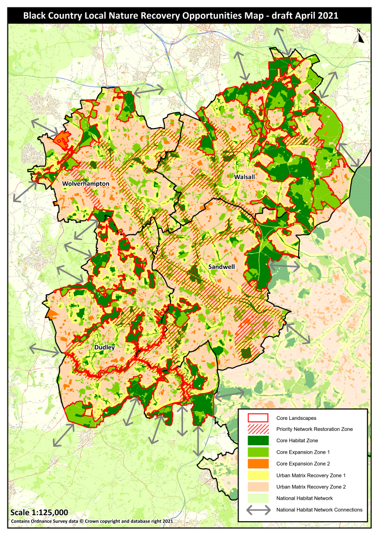
Black Country Local Nature Recovery Opportunity Map (draft April 2021)
- A requirement of the Environment Bill is a Local Habitat Map that identifies the existing distribution of different habitat types and the location of areas already important for biodiversity, overlaid by locations considered suitable for delivering the outcomes and measures identified in the Statement of Biodiversity Priorities.
- The draft Black Country Local Nature Recovery Opportunity Map has been produced by the Wildlife Trust for Birmingham and the Black Country and the Local Environmental Records Centre (EcoRecord) through analysis of local and national data sets including designated sites, priority habitats, species distribution, land use and ecological connectivity. The map comprises a number of components that depict the areas of current high ecological value, ecological connectivity between these areas, and prioritises opportunities for investment in nature's recovery on a landscape scale.
- Core Landscapes are large areas of land comprised of multiple land use parcels that are ecologically coherent, often sharing similar geology, soil types, habitats, landscape character and land use history. Core Landscapes typically support the highest abundance and diversity of semi-natural and Priority Habitats. They provide significant opportunity and are a priority for investment in ecological recovery (e.g. habitat restoration and creation).
- Priority Network Restoration Zones are areas where investment in ecological recovery outside of Core Landscapes has been prioritised. They have been selected on the basis of being those areas that contain the highest density of Core Habitat and Core Expansion land use parcels which collectively link Core Landscapes. Their purpose is to support the creation of a coherent ecological network across the Black Country landscape.
- The Core Habitat Zone is comprised of land use parcels that contain the most ecologically valuable habitats, and includes all areas with a high ecological value, all sites with a nature conservation designation, and priority habitat areas identified in Natural England's Combined Habitat Network data set. The Core Habitat Zone is a priority for protection and restoration.
- Core Expansion Zone 1 comprises land use parcels that are of lower ecological value than those in the Core Habitat Zone but, due to inherent value or location, have the most potential to contribute to a coherent ecologic network. These sites are a priority for investment in the restoration and creation of new habitats.
- Core Expansion Zone 2 sites provide an opportunity for the restoration and creation of new habitats but investment in these areas is a lower priority than in Zone 1.
- Urban Matrix Recovery Zone 1 comprises all features of the built environment within c. 150 metres of the Core Habitat Zone, and may include residential and commercial properties, gardens, road verges, street trees and minor watercourses. The protection, enhancement and creation of green infrastructure within these areas is a priority.
- Urban Matrix Recovery Zone 2 comprises all features of the built environment outside of Zone 1. These areas provide an opportunity for the protection, enhancement and creation of green infrastructure but investment in these areas is a lower priority than in Zone 1.
- National Habitat Network is Natural England's Combined Habitat Networks data set.
Need help completing this? Click here for our simple user guide.