
Draft Plan Consultation: Additional Housing Sites in Walsall (Regulation 18)
Strategic Allocations
Two of the new sites that form part of this consultation are being classed as strategic allocation, these are:
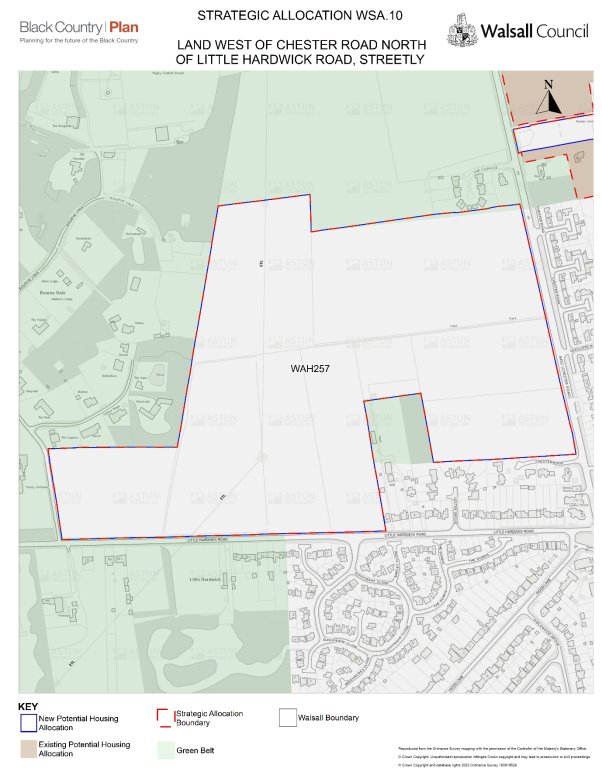
- WAH 257 – Land West of Chester Road North of Little Hardwick Road, Streetly which is a new strategic allocation WSA10 - Land West of Chester Road North of Little Hardwick Road, Streetly
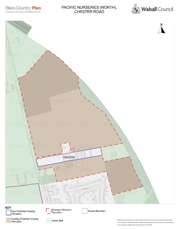
- WAH 259 – Pacific Nurseries, which is being added to Policy WSA9 – Land to the east of Chester Road, north of Pacific Nurseries, Hardwick which was consulted on last year as part of the main Reg 18 consultation
The following strategic allocations are large sites that are significant in size and that have specific development considerations. Decisions on planning applications for these sites should be made in accordance with the specific policy requirements listed in this document.
For each site where the allocation includes housing, an indicative site capacity is provided. The precise number of homes to be developed will be determined through the planning application process.
Streetly
Policy WSA9 – Land to the east of Chester Road, Pacific Nurseries, Hardwick
General introduction
Land to the east of Chester Road (WAH230), north of Pacific Nurseries (WAH246), Pacific Nurseries (WAH254) and Pacific Nurseries (North) (WAH277) are a cluster of four sites, currently used for a mix of agriculture, horse grazing and a garden centre. To the east is a railway line with a golf course beyond it; to the south lies the urban edge of Streetly; and to the west are agricultural fields. Within the area there is a bungalow which is not part of the development allocations
The developable site area is 14.19ha.
The estimated capacity of the site is 496 houses.
Mixed tenure housing is suitable with higher densities of at least 35dph and affordable housing provision.
Design principles:
- Deliver appropriate local facilities to support the new residents and to enhance the sustainability of the existing area, including a new primary school and local health centre.
- Investigation and detailed proposals for remediation of contaminated land.
- A transport strategy that ensures the transport impacts of the development are appropriately managed and mitigated.
- Enhanced provision for pedestrians and cyclists, including enhanced connectivity with the local centre.
- A site-wide Sustainable Drainage Strategy, to ensure that drainage requirements can be met on site and that is designed to deliver landscape, biodiversity and amenity benefits.
- A strategy for landscape and habitat creation which provides enhancement, retention and mitigation for established trees, to ensure there is no significant adverse impact on visual amenity and character nor on protected animal species.
- The site is in a Mineral Safeguarding Area (MSA), which means that prior extraction of sand and gravel will take place where it is practical and environmentally feasible to do so.
Policy WSA10 - Land West of Chester Road North of Little Hardwick Road, Streetly
General introduction
Land West of Chester Road North of Little Hardwick Road, Streetly (WAH275) are existing fields predominantly used for agriculture. To the West is Bourne Vale a low density residential area with a woodland setting, to the South is Little Hardwick Road a residential street which meets the crossroads to Chester Road with a mix of uses including restaurants, retail and a public house. Chester Road is to the East which in this locality is residential and to the North is The Coppice a residential estate on the site of Water Works Farm with fields beyond.
The developable site area is 25.98ha.
The estimated capacity of the site is 655 houses.
Mixed tenure housing is suitable with higher densities of at least 35dph and affordable housing provision.
Design principles
- Deliver appropriate local facilities to support the new residents and to enhance the sustainability of the existing area, including a new primary school and local health centre.
- Investigation and detailed proposals for remediation of contaminated land.
- A transport strategy that ensures the transport impacts of the development are appropriately managed and mitigated.
- Enhanced provision for pedestrians and cyclists, including enhanced connectivity with the local centre.
- A site-wide Sustainable Drainage Strategy, to ensure that drainage requirements can be met on site and that is designed to deliver landscape, biodiversity and amenity benefits.
- A strategy for landscape and habitat creation which provides enhancement, retention and mitigation for established trees and SLINCS, to ensure there is no significant adverse impact on visual amenity and character nor on protected animal species.
- The site is in a Mineral Safeguarding Area (MSA), which means that prior extraction of sand and gravel will take place where it is practical and environmentally feasible to do so.